Georgina Island
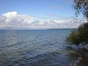
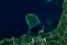
Georgina Island is located in southern Ontario, Canada about an hour north from Toronto. It is the largest island within Lake Simcoe.[1] The island is a Native reserve occupied by the Ojibwa people. It is also within the Town of Georgina and in the Regional Municipality of York.
Before the completion of the Trent–Severn Waterway, the water level on Lake Simcoe was low enough to enable residents to cross in wagons or walk in ankle-deep water to the mainland, at Virginia Beach, Ontario. After the Trent Severn Waterway was completed, the water level increased enough to drown traditional farmlands and to require a boat for crossing to the mainland.[2][3]
Pope John Paul II stayed on neighbouring Strawberry Island for four days just before World Youth Day 2002 in Toronto.[4]
The island is reached by a ferry in summer and an airboat in winter. On the coldest days of winter Lake Simcoe is cold enough for an ice road to be built allowing light vehicles to drive across the frozen lake. The Women's Support Network of York Region has worked with the First Nations of Georgina Island.[5]
Settlement

The Ojibwa residing along the Lake Simcoe region were of two groups. Led by William Yellowhead and Joseph Snake they occupied an area in the southernmost area of Simcoe County. A third group led by John Aisance occupied an area of Kempenfelt Bay, with the creation of the Coldwater and Narrows Reserve, located between Lake Couchiching, and the Severn River. Yellowhead and Snake primarily settled at the Narrows, while Aisance and his people settled at Coldwater. During the American War of Independence in 1776, Europeans began to strategically engage in relationship with the Native people for purposes of defence of British North America. The role of the colonial government had a significant impact on the people, enforcing a policy to enrol the people and grow dependent on the crown. The influence of this policy resulted in repeated promises of protection, food, clothing, lodgings and general welfare of the people. The transformation from a strong and independent people to one of complete dependence for the most part resulted. The area between Lake Ontario, Georgian Bay and Lake Simcoe represented a region of prime military vulnerability and defence for Upper Canada.[6] This region was not only occupied by the Lake Simcoe Indians, but also the people under the leadership of Joseph Brant of the Six Nations. Six Nations lies in the town of Ohsweken, Ontario.[7]
References
| Wikimedia Commons has media related to Georgina Island. |
- ↑ http://atlas.nrcan.gc.ca/site/english/learningresources/facts/lakes.html#ontario
- ↑ "Georgina Island The Jewel of the Lake" (PDF). http://georginamaps.ca. The Alliance for a Better Georgina. 2007. Retrieved 18 December 2014. External link in
|website=(help) - ↑ "Lake Simcoe Water Levels" (PDF). http://www.lsrca.on.ca. Lake Simcoe Region Conservation Authority. August 2013. Retrieved 18 December 2014. External link in
|website=(help) - ↑ John Paul to rest as cross makes way through Toronto
- ↑ "Council Meeting Minutes". Aurora. September 28, 2010. p. 12. Retrieved November 29, 2013.
- ↑ http://www.georginaisland.com
- ↑ http://www.sixnations.ca/
Coordinates: 44°22′29″N 79°17′37″W / 44.3747°N 79.2937°W