Georgia State Route 260
| ||||
|---|---|---|---|---|
| Glenwood Avenue SE | ||||
 | ||||
| Route information | ||||
| Maintained by GDOT | ||||
| Length: | 1.2 mi[1] (1.9 km) | |||
| Existed: | 1949[2][3] – present | |||
| Major junctions | ||||
| West end: |
| |||
| East end: |
| |||
| Location | ||||
| Counties: | DeKalb | |||
| Highway system | ||||
| ||||

State Route 260 (SR 260) is a very short west-east state highway located in the northern part of the U.S. state of Georgia. Its route is entirely within DeKalb County.
Route description
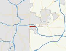
SR 260 begins at an intersection with US 23/SR 42 (Moreland Avenue SE) in Atlanta. The route makes a beeline to the east to meet its eastern terminus, an interchange with I-20 just east of Atlanta.[1]
The route is a mostly urban route, passing mostly businesses, churches, and schools. At its eastern terminus is DeKalb Memorial Park.[1]
No section of SR 260 is part of the National Highway System, a system of routes determined to be the most important for the nation's economy, mobility and defense.[4]
History
SR 260 was established in 1949 on a routing that had the same western terminus at US 23/SR 42, but went further to the east, to an intersection with SR 12. At that time, the entire route was paved.[2][3]
Major intersections
The entire route is in DeKalb County.
| Location | mi[1] | km | Destinations | Notes | |
|---|---|---|---|---|---|
| Atlanta | 0.0 | 0.0 | Western terminus | ||
| | 1.2 | 1.9 | Eastern terminus; I-20 exit 61B | ||
| 1.000 mi = 1.609 km; 1.000 km = 0.621 mi | |||||
See also
-
.svg.png) Georgia (U.S. state) portal
Georgia (U.S. state) portal -
 Atlanta portal
 -
 U.S. Roads portal
References
- 1 2 3 4 Google (February 20, 2013). "Route of SR 260" (Map). Google Maps. Google. Retrieved February 20, 2013.
- 1 2 Georgia State Highway System (PDF) (Map). Cartography by GSHD. Georgia State Highway Department. February 28, 1948. Retrieved February 20, 2013.
- 1 2 Georgia State Highway System (PDF) (Map). Cartography by GSHD. Georgia State Highway Department. April 1, 1949. Retrieved February 20, 2013.
- ↑ "National Highway System: Georgia" (PDF). United States Department of Transportation. May 8, 2009. Retrieved February 20, 2013.