Georgia State Route 18
| ||||
|---|---|---|---|---|
 | ||||
| Route information | ||||
| Maintained by GDOT | ||||
| Length: | 148.0 mi[1] (238.2 km) | |||
| Major junctions | ||||
| West end: |
| |||
|
| ||||
| East end: |
| |||
| Location | ||||
| Counties: | Troup, Harris, Meriwether, Pike, Lamar, Monroe, Jones, Wilkinson, Twiggs | |||
| Highway system | ||||
| ||||

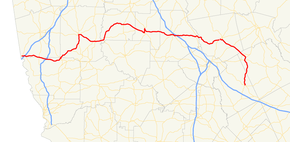
State Route 18 (SR 18) is a 148-mile-long (238 km) state highway that runs west-to-east through portions of Troup, Harris, Meriwether, Pike, Lamar, Monroe, Jones, Wilkinson, and Twiggs counties in the western and central parts of the U.S. state of Georgia. The route connects West Point, just east of Alabama state line, with Jeffersonville, via Barnesville.
Route description
The route runs east from its western terminus in West Point in Troup County, crosses I-85 just east of West Point, and dips slightly southeasterly into northern Harris County, where is crosses I-185 and continues to Pine Mountain on the county line with Meriwether County. Turning northeast, SR 18 runs to Greenville in central Meriwether County, and is co-signed with US 27 from their intersection south of Greenville into downtown Greenville, where SR 18 turns southeast, is co-signed with SR 109, and runs to Woodbury.
Turning east and crossing into Pike County, the route again turns northeast and runs through Molena, where its concurrence with SR 109 ends, into Concord, where it curves east and runs to Zebulon. Curving once again to the southeast, SR 18 crosses into Lamar County and runs to and around Barnesville, where it begins its overlap with US 41, before heading into Forsyth in Monroe County, ending the overlap with US 41, and where it crosses I-75 shortly after leaving Forsyth. The route continues east into Jones County and runs into Gray, where it is briefly co-signed with US 129, SR 11, and SR 22, and where it turns southeast once more in the direction of Gordon in Wilkinson County.
In Gordon, the route turns south and southeast, crosses into Twiggs County, and reaches its eastern terminus in Jeffersonville.
SR 18 is not part of the National Highway System, a system of roadways important to the nation's economy, defense, and mobility.[2]
Major intersections
| County | Location | mi | km | Destinations | Notes |
|---|---|---|---|---|---|
| Troup | West Point | Western terminus | |||
| I-85; exit 2 | |||||
| Northern terminus of SR 103 | |||||
| Troup–Harris county line | | ||||
| Harris | | I-185; exit 34 | |||
| | Western terminus of SR 354 | ||||
| Pine Mountain | Southern terminus of US 27/SR 1 concurrency | ||||
| Northern terminus of US 27/SR 1 concurrency | |||||
| Meriwether | | Western terminus of SR 194 | |||
| | Southern end of US 27 Alt./SR 41 concurrency | ||||
| Greenville | Northern end of US 27 Alt./SR 41 concurrency, eastern end of SR 109 concurrency | ||||
| Western terminus of SR 109 Spur | |||||
| Woodbury | |||||
| Western end of SR 74 concurrency | |||||
| Pike | | Eastern end of SR 74 concurrency | |||
| Molena | Eastern end of SR 109 concurrency | ||||
| Zebulon | One way pair | ||||
| Lamar | | Eastern terminus of SR 109 | |||
| Barnesville | Western end of US 41/SR 7/SR 36 concurrency | ||||
| Eastern end of SR 36 concurrency | |||||
| | Eastern end of SR 7 concurrency | ||||
| Monroe | Forsyth | Western end of SR 83 concurrency | |||
| Eastern end of SR 83 concurrency | |||||
| Northern terminus of SR 19, eastern end of US 41 concurrency | |||||
| I-75; exit 185 | |||||
| | |||||
| Jones | Gray | Western end of US 129/SR 11/SR 22 concurrency | |||
| Eastern end of US 129/SR 11/SR 22 concurrency | |||||
| Southern terminus of SR 44 | |||||
| | |||||
| Wilkinson | Gordon | Southern terminus of SR 243 | |||
| Western terminus of SR 18 Spur | |||||
| | |||||
| Twiggs | Jeffersonville | Eastern terminus | |||
1.000 mi = 1.609 km; 1.000 km = 0.621 mi
| |||||
Gordon spur
| |
|---|---|
| Location: | Gordon |
See also
-
.svg.png) Georgia (U.S. state) portal
Georgia (U.S. state) portal -
 U.S. Roads portal
References
- ↑ Google (August 23, 2013). "Route of SR 18" (Map). Google Maps. Google. Retrieved August 23, 2013.
- ↑ "National Highway System: Georgia" (PDF). United States Department of Transportation. October 1, 2012. Retrieved September 5, 2013.
External links
-
 Media related to Georgia State Route 18 at Wikimedia Commons
 - Georgia Roads (Routes 1 - 20)