Georgia State Route 125
| ||||
|---|---|---|---|---|
 | ||||
| Route information | ||||
| Maintained by GDOT | ||||
| Length: | 74.4 mi[1] (119.7 km) | |||
| Major junctions | ||||
| South end: |
| |||
|
| ||||
| North end: |
| |||
| Location | ||||
| Counties: | Lowndes, Lanier, Berrien, Tift, Irwin, Ben Hill | |||
| Highway system | ||||
| ||||

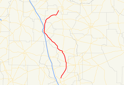
State Route 125 (SR 125) is a 74.4-mile-long (119.7 km) state highway that runs south-to-north in an S-shape through portions of Lowndes, Lanier, Berrien, Tift, Irwin, and Ben Hill counties in the southern part of the U.S. state of Georgia. It connects the Valdosta and Fitzgerald areas.
Route description
SR 125 begins at an intersection with US 41 Business/SR 7 Business (North Ashley Street), in the central part of Valdosta, in Lowndes County. It heads north-northeast to meet US 41/SR 7 (Inner Perimeter Road), just before leaving the city. The route runs north-northeast, past Freedom Park and passes through Moody Air Force Base and intersects SR 122 at the meeting point of Lowndes, Berrien, and Lanier counties. It travels to the north along the Berrien–Lanier county line and then jogs slightly to the northeast, entering Lanier County proper. In Berrien County, it curves to the north-northwest before entering Ray City. Here, it meets US 129/SR 11/SR 37 (Main Street). At this intersection, US 129/SR 11 begin a concurrency. The three highways head north-northwest to Nashville. In town, SR 76 (Adel Highway) joins the concurrency through Nashville. In the central part of town, the four concurrent routes intersect SR 168 (East McPherson Avenue). Just after that SR 76 departs to the east on East Marion Avenue, while SR 125 departs to the west on West Marion Avenue. It heads northwest through rural areas of the county and enters Tift County. In Tift County, it intersects US 41/SR 7 next to the Henry Tift Myers Airport, just southeast of Unionville. US 41/SR 7/SR 125 head concurrent to the north. In Tifton, the highway meets US 82/US 319/SR 35/SR 520 (East 5th Street). Farther into town, SR 125 splits off to the northeast and enters Irwin County. It runs northeast until it joins SR 32 (Sycamore Highway). They run concurrent to the northeast, through Irwinville, and to the east-southeast until SR 32 (Mystic Highway) splits off to the southeast. SR 125 curves to the northeast and continues in that direction until it meets its northern terminus, an intersection with SR 107 (Benjamin H. Hill Drive West), at the southwestern edge of Fitzgerald.[1]
The only part of SR 125 that is part of the National Highway System, a system of roadways important to the nation's economy, defense, and mobility, is the section from the US 82/US 319/SR 35/SR 520 intersection in Tifton north to Fitzgerald.[2]
Major intersections
| County | Location | mi[1] | km | Destinations | Notes | |||
|---|---|---|---|---|---|---|---|---|
| Lowndes | Valdosta | 0.0 | 0.0 | Southern terminus | ||||
| 1.8 | 2.9 | |||||||
| Lowndes–Berrien– Lanier county tripoint | | 12.9 | 20.8 | |||||
| Lanier |
No major junctions | |||||||
| Berrien | Ray City | 16.3 | 26.2 | Southern end of US 129/SR 11 concurrency | ||||
| Nashville | 25.7 | 41.4 | Southern end of SR 76 concurrency | |||||
| 26.2 | 42.2 | Western terminus of SR 168 | ||||||
| 26.2 | 42.2 | Northern end of SR 76 concurrency | ||||||
| 26.2 | 42.2 | Northern end of US 129/SR 11 concurrency | ||||||
| Tift | | 48.3 | 77.7 | Southern end of US 41/SR 7 concurrency | ||||
| Tifton | 50.2 | 80.8 | ||||||
| 51.2 | 82.4 | Northern end of US 41/SR 7 concurrency | ||||||
| Irwin | | 64.8 | 104.3 | Southern end of SR 32 concurrency | ||||
| | 69.3 | 111.5 | Northern end of SR 32 concurrency | |||||
| Ben Hill | Fitzgerald | 74.4 | 119.7 | Northern terminus | ||||
1.000 mi = 1.609 km; 1.000 km = 0.621 mi
| ||||||||
See also
-
.svg.png) Georgia (U.S. state) portal
Georgia (U.S. state) portal -
 U.S. Roads portal
References
- 1 2 3 Google (July 7, 2013). "Route of SR 125" (Map). Google Maps. Google. Retrieved July 7, 2013.
- ↑ "National Highway System: Georgia" (PDF). United States Department of Transportation. October 1, 2012. Retrieved July 7, 2013.
External links
-
 Media related to Georgia State Route 125 at Wikimedia Commons
 - Georgia Roads (Routes 121 - 140)