George M. Bryan Airport
| George M. Bryan Airport (former Starkville AF Aux. Field) | |||||||||||
|---|---|---|---|---|---|---|---|---|---|---|---|
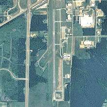 USGS 2006 orthophoto | |||||||||||
| IATA: none – ICAO: KSTF – FAA LID: STF | |||||||||||
| Summary | |||||||||||
| Airport type | Public | ||||||||||
| Owner | City of Starkville | ||||||||||
| Serves | Starkville, Mississippi | ||||||||||
| Elevation AMSL | 333 ft / 101 m | ||||||||||
| Coordinates | 33°25′59″N 088°50′55″W / 33.43306°N 88.84861°WCoordinates: 33°25′59″N 088°50′55″W / 33.43306°N 88.84861°W | ||||||||||
| Map | |||||||||||
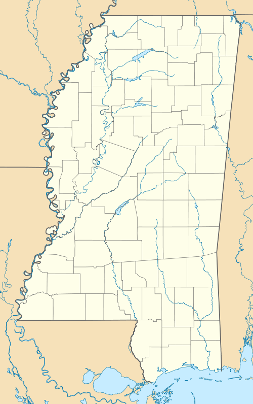 STF Location of airport in Mississippi | |||||||||||
| Runways | |||||||||||
| |||||||||||
| Statistics (2012) | |||||||||||
| |||||||||||
George M. Bryan Airport[1][2] (ICAO: KSTF, FAA LID: STF) is a public use airport in Oktibbeha County, Mississippi, United States.[1] It is owned by the City of Starkville and located three nautical miles (6 km) southwest of its central business district.[1] This airport is included in the National Plan of Integrated Airport Systems for 2011–2015, which categorized it as a general aviation facility.[3]
Also known as Starkville / Oktibbeha County Airport or George M. Bryan Field,[4] the airport was named in honor of World War II veteran and Starkville native George Martin Bryan.[5]
Although many U.S. airports use the same three-letter location identifier for the FAA and IATA, this airport is assigned STF by the FAA[1] but has no designation from the IATA[6] (which assigned STF to Stephens Island in Queensland, Australia).[7]
History
Opened in 1934 as Starkville Municipal Airport. During World War II the airport was taken over abruptly by the government to be used as a glider training base (Starkville AF Auxiliary Field). Plans for the AAF Basic Training Detachment were for 150 students using the TG-5 gliders. The gliders were towed by the BT-13 Vultee "Vibrator". Students lived in the dormitories at Mississippi State College, where they also used its classrooms and dining facilities. [8]
Facilities and aircraft
George M. Bryan Airport covers an area of 635 acres (257 ha) at an elevation of 333 feet (101 m) above mean sea level. It has one runway designated 18/36 with an asphalt and concrete surface measuring 5,550 by 150 feet (1,692 x 46 m).[1]
For the 12-month period ending January 19, 2012, the airport had 22,520 aircraft operations, an average of 61 per day: 98% general aviation and 2% military. At that time there were 40 aircraft based at this airport: 72.5% single-engine, 17.5% glider, 5% jet, 2.5% multi-engine, and 2.5% helicopter.[1]
See also
References
- 1 2 3 4 5 6 7 FAA Airport Master Record for STF (Form 5010 PDF). Federal Aviation Administration. Effective November 15, 2012.
- ↑ "George M. Bryan Airport". Oktibbeha County. Retrieved August 14, 2013.
- ↑ "2011–2015 NPIAS Report, Appendix A" (PDF, 2.03 MB). National Plan of Integrated Airport Systems. Federal Aviation Administration. October 4, 2010. External link in
|work=(help) - ↑ "Starkville / Oktibbeha County Airport". City of Starkville. Retrieved August 14, 2013.
- ↑ "George M. Bryan Field". Raspet Flight Research Laboratory.
- ↑ "George M. Bryan Airport (IATA: none, ICAO: KSTF, FAA: STF)". Great Circle Mapper. Retrieved August 14, 2013.
- ↑ "IATA Airport Code Search (STF: Stephens Island)". International Air Transport Association. Retrieved August 14, 2013.
- ↑
 This article incorporates public domain material from the Air Force Historical Research Agency website http://www.afhra.af.mil/.
External links
- George M. Bryan Airport at Oktibbeha County website
- Starkville / Oktibbeha County Airport at City of Starkville website
- Aerial image as of March 1996 from USGS The National Map
- FAA Terminal Procedures for STF, effective November 10, 2016
- Resources for this airport:
- FAA airport information for STF
- AirNav airport information for KSTF
- FlightAware airport information and live flight tracker
- NOAA/NWS latest weather observations
- SkyVector aeronautical chart, Terminal Procedures