Geological compass


There are a number of different (specialised) magnetic compasses used by geologists to measure orientation of geological structures, as they map in the field, to analyse (and document) the geometry of bedding planes, joints, and/or metamorphic foliations and lineations.[1][2] In this aspect the most common device used to date is the analogue compass.
Classic geological compasses
Classic geological compasses that are of practical use combine two functions, direction finding and navigation (especially in remote areas), and the ability to measure strike and dip of bedding surfaces and/or metamorphic foliation planes. Structural geologists (i.e. those concerned with geometry and the pattern of relative movement) also have a need to measure the plunge and plunge direction of lineations.
Compasses in common use include the Brunton compass and the Silva compass.
Modern geological compasses
-
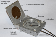
Setup of a modern geological compass after Prof. Clar (Freiberger), total view
-
_en.svg.png)
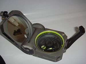
top view
-
_en.svg.png)
bottom side
The concept of modern geological compass was developed by Eberhard Clar of the University of Vienna during his work as structural geologist. He published it in 1954.[3] An advantage of his concept is that strike and dip is measured in one step, using the vertical circle for dip angle and the compass for the strike direction. The first implementation was done by the VEB Freiberger Präzisionsmechanik in Freiberg, Germany. The details of the design were made in a close cooperation with the Freiberg University of Mining and Technology.[4]
-
Breithaupt geological compass COCLA with damping of the oscillations of the magnetic needle
-
Brunton Pocket Transit, it combines the features of classic and modern geological compasses
-

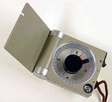
Freiberg geological compass of FPM
-

Chinese geological compass
-

Russian geological compass
Usage

At first sight it appears confusing to the novice user, for the numbers on the compass dial ascend in an anticlockwise direction. This is because the compass is used to determine dip and dip-direction of surfaces (foliations), and plunge and plunge-direction of lines (lineations). To use the compass one aligns the lid of the compass with the orientation of the surface to be measured (to obtain dip and dip direction), or the edge of the lid of the compass with the orientation of the line (to obtain plunge and plunge direction). The compass must be twisted so that the base of the compass becomes horizontal, as accomplished using the spirit level incorporated in it. The needle of the compass is then freed by using the side button, and allowed to spin until the damping action slows its movement, and then stabilises. The side button is released and the needle is then firmly held in place, allowing the user thereafter to conveniently read the orientation measured. One first reads the scale that shows the angle subtended by the lid of the compass, and then depending on the colour shown (red or black) the end of the compass needle with the corresponding colour. Data are then recorded as (for example) 25°->333° (dip and dip-direction) or (plunge and plunge-direction).
This compass has the most use by structural geologists, measuring foliation and lineation in metamorphic rocks, or faults and joints in mining areas.
Digital compasses
With the advent of the smartphone, geological compass programs based on the 3-axis teslameter and the 3-axis accelerometer have also begun to appear. These compass programs use vector algebra to compute plane and lineation orientations from the accelerometer and magnetometer data, and permit rapid collection of many measurements. However, some problems are potentially present. Measurements made by smartphone geological compasses can potentially be susceptible to noise, mainly due to vibration or rapid hand movement. Users of a smartphone compass should carefully calibrate their devices and run several tests against traditional magnetic compasses in order to understand the limitations of their chosen program.
There are several different digital geological compasses now available, including the listerCompass . This is based on software that bypasses the inherent inaccuracy of the 'Heading' function by recording data from the magnetometers and to the accelerometers, and then computing the orientation of the iPhone using vector algebra. The accelerometers record vibration, so the iPhone needs be held still. Since very many measurements can be made in a few seconds, statistical analysis can be applied. High variance implies scattered data, so measurement should be continued until error diminishes to an acceptable level.
It is important to consider such aspects in using a geological compass, for traditional compasses rely on inertia to remove error caused by operator movement. With traditional compasses there is no record of error caused by poor damping or operator movement. This limitation is removed by use of a digital compass, though these may be more error prone because of the sensitivity of the accelerometer, which programs use to determine vertical and horizontal. Therefore, professional use of a digital geological compass requires the recoding of variance in individual measurements.
In addition, since there is no guarantee given by individual manufacturers, it should not be assumed that the magnetometer axes, and the accelerometer axes, have been accurately aligned to the orientation of the iPhone. Professional digital compass software therefore requires a calibration procedure. As noted above, this can be attempted by comparing data from traditional compasses and a digital compass, for example by slowly rotating both compasses together on a fixed horizontal or inclined surface.
There is no data that suggests digital compasses on the iPhone are subject to any measurable form of magnetic disturbance.
References
- ↑ The Mapping of Geological Structures (Geological Society of London Handbook Series) [Paperback] K. R. McClay
- ↑ Statistics of Earth Science Data: Their Distribution in Time, Space and Orientation [Paperback] Graham J. Borradaile (Author)
- ↑ Clar, E.: A dual-circle geologist’s and miner’s compass for the measurement of areal and linear geological elements Separate print from the negotiations of the Federal Institute of Geology Vienna, 1954, vol. 4
- ↑ http://www.fpm.de/downloads/GeologistCompass_eng.pdf
- Marjoribanks, Roger W. (1997). Geological Methods in Mineral Exploration and Mining. Springer. p. 105. Retrieved 27 June 2012.
External links
- Breithaupt Precision Instruments Geological Compass
- Freiberg Precision Instruments (FPM) Geological Compass
- Brunton Geological Compass