Geography of Odisha


Odisha is a state in the Republic of India. It is situated in the eastern part of the country. It is surrounded by West Bengal to the north-east and in the east, Jharkhand to the north, Chhattisgarh to the west and north-west and Andhra Pradesh to the south. The state has an area of 155,707 km2 and extends for 800 kilometres from north to south and 500 kilometres from east to west. Its coastline is 480 kilometres long. The state is divided into 30 districts which are further subdivided into 314 blocks.
Overview
Odisha's topography comprises fertile plains along the coast and forested highlands towards the interior. The Odia people are generally of Indo-Aryan stock. The state is mostly famous for lord Jagannath temple which is situated in puri.(19.8048° N, 85.8180° E).
The Chota Nagpur plateau occupies the western and northern portions of the state, while along the coast are fertile alluvial plains and the valleys of the Mahanadi, Brahmani, and Baitarani rivers, which empty into the Bay of Bengal. These alluvial plains are home to intensive rice cultivation. A major nesting ground for the Olive Ridley sea turtles can be found in the beaches of Odisha; in Devi, Gahirmatha and Rushikulya are known nesting sites for the L. olivacea Indian Ocean population. In 2007, around 130,000 turtles nested on the beaches of Gahirmatha.
Although much of Odisha's forest cover has been denuded lately, one of the greatest attractions of Odisha is its still vast expanses of unspoiled natural landscape that offer a protected yet natural habitat to the state’s incredible wildlife. There are many wildlife sanctuaries in Odisha. The Simlipal National Park Tiger Reserve is a huge expanse of lush green forest with waterfalls, inhabited by tigers, elephants, and other wildlife. The Bhitarkanika Wildlife Sanctuary has been protecting estuarine crocodiles since 1975.
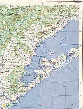
Chilka Lake, a brackish water coastal lake on the Bay of Bengal, south of the mouth of the Mahanadi River, is the largest coastal lake in India. It is protected by the Chilka Lake Bird Sanctuary, which harbors over 150 migratory and resident species of birds.
The highest mountain peak in the state is Deomali (1672 m), which is situated in Koraput district in southern Odisha. It is also one of the tallest peaks of the Eastern Ghats. Deomali is part of the Chandragiri-Pottangi mountain subsystem.
Location
The state of Odisha extends from 17.49N latitude to 22.34N latitude and from 81.27E longitude to 87.29E longitude.
Physical divisions
Physiography
On the basis of homogeneity, continuity and physiographical characteristics, Odisha has been divided into five major regions:
- The coastal plains in the east
- The middle mountainous and highlands region
- The central plateaus
- The western rolling uplands, and
- The major flood plains
Odisha Coastal Plains
The Odisha Coastal Plains or Utkal Plains are the depositional landforms of recent origin and geologically belong to the Post-Tertiary Period. The 75 metre contourline delimits their western boundary and differentiates them from the Middle Mountainous Region. This region stretches from the West Bengal border, i.e. from the River Subarnarekha in the north to the River Rushikulya in the south.
This region is the combination of several deltas of varied sizes and shapes formed by the major rivers of Odisha, such as the Subarnarekha, the Budhabalanga, the Baitarani, the Brahmani, the Mahanadi, and the Rushikulya. Therefore, the coastal plain of Odisha is called the "Hexadeltaic region" or the "Gift of Six Rivers". It stretches along the coast of the Bay of Bengal having the maximum width in the Middle Coastal Plain (the Mahanadi Delta), narrow in the Northern Coastal Plain (Balasore Plain) and narrowest in the Southern Coastal Plain (Ganjam Plain). The North Coastal Plain comprises the deltas of the Subarnarekha and the Budhabalanga rivers and bears evidences of marine transgressions. The Middle Coastal Plain comprises the compound deltas of the Baitarani, Brahmani and Mahanadi rivers and bears evidences of past 'back bays' and present lakes. The South Coastal Plain comprises the laccustrine plain of Chilika lake and the smaller delta of the Rushikulya River.
Middle Mountainous and Highlands Region
The region covers about three-fourth of the entire State. Geologically it is a part of the Indian Peninsula which was a part of the ancient landmass of Gondwanaland. The major rivers of Odisha with their tributaries have cut deep and narrow valleys. This region mostly comprises the hills and mountains of the Eastern Ghats which rise abruptly and steeply in the east and slope gently to a dissected plateau in the west running from north-west (Mayurbhanj) to south-west (Malkangiri). The Odisha highlands are also known as the Garhjat Hills. This region is well marked by a number of interfluves or watersheds. The Eastern Ghats is interrupted by a number of broad and narrow river valleys and flood plains. The average height of this region is about 900 metres above the mean seal level. The highest peak is Deomali.
Central Plateaus
The plateaus are mostly eroded plateaus forming the western slopes of the Eastern Ghats with elevation varying from 305–610 metres. There are two broad plateaus in Odisha : (i) the Panposh – Keonjhar -Pallahara plateau comprises the Upper Baitarani catchment basin, and (ii) the Nabrangpur – Jeypore plateau comprises the Sabari basin.
Western Rolling Uplands
These are lower in elevation than the plateaus having heights varying from 153 metres to 305 metres.[1]
Forests

Almost one-third of Odisha is covered by forests which make up about 37.34% of the total land area of the state. These forests cover most of southern and western Odisha. The eastern plains adjacent to the coast are covered by farmlands. The forest cover of Odisha extends over an area of 58,136.869 square kilometres out of which reserve forests make up an area of 26,329.12 square kilometres (10,165.73 square miles), demarcated protected forests make up 11,687.079 square kilometres (4,512.406 square miles)mi) and undemarcated protected forests make up 3,638.78 square kilometres (1,404.94 square miles)mi). Other types of forests make up 16,261.34 square kilometres (6,278.54 square miles)mi) while unclassed forests make up 20.55 square kilometres (7.93 square miles)mi) of the total forest cover. The State Government of Odisha also classifies forests based on their density. About 538 square kilometres (208 square miles)mi) of land are classified as very dense forests with a canopy density of over 70 percent, 27,656 square kilometres (10,678 square miles)mi) of forests are classified as moderately dense cover with a canopy density of 40 to 70 percent and 20,180 square kilometres (7,790 square miles)mi) of land are classified as open forest with a canopy density of 10 to 40 percent.
Rivers

There are four groups of rivers which flow through Odisha into the Bay of Bengal (Table-2). They are:
(i) Rivers that have a source outside the State (the Subarnarekha, the Brahmani the IB and the Mahanadi).
(ii) Rivers having a source inside the State (the Budhabalanga, the Baitarani, the Salandi, and the Rushikulya).
(iii) Rivers having a source inside the Odisha, but flow through other states (the Bahuda, the Vamsadhara River, and the Nagavali River).
(iv) Rivers having a source inside Odisha, but tributary to rivers which flow through other states (the Machkund, the Sileru River, the Kolab, and the Indravati River).
- River Mahanadi: It is the major river of Odisha and the sixth largest river in India. It originates from the sihawa hills of the Bastar Plateau in Raipur district of [Chhattishgarh]. It is about 857 km long (494 km in Odisha) and its catchment area spreads over 141,600 km2. (65,580 km².) in Odisha. The river carries on an average about 92,600 million m of water.
- River Kathajodi: Around Naraj Bridge which is approx. 10 km from Cuttack City there are following villages:- Naraja Marthapur (Local Railway Station), Godi Sahi, Sandhapur, Bidyadharapur, Nua Sahi & Ratagarh. All these villages are rich in ancient heritage. Ratagarh, there is an ancient Shiva Temple of Chola Dynasty. It is approximately 15 km from the City of Bhubaneswar and approximately 6 km from Nandan Kanan, the Zoological Park. A canal arises from the Main Mahanadi river at Naraj Bridge is running besides which is the main source of water system. In Ratagarh there are 3-4 small hills which connects to the Chandaka-Damapada elephant reservoir. The main cultivation of the people of these villages are paddy besides vegetales also. The railway line running between the above villages connects Bhubaneswar with Talcher, the thermal power station, Sambalpur, Athagarh and then run into the states of Madhya Pradesh.
- The Brahmani: It is the second largest river in Odisha. It originates as two major rivers like the Sankh and the Koel from the Chota Nagpur Plateau of Bihar and both join at Veda Vyasa near Rourkela of Sundargarh district of Odisha forming the major River Brahmani. It flows through the Eastern Ghats in Sundargarh, Deogarh, Kendujhar, Dhenkanal, Bhadrak and Jajpur districts into the Coastal Plains and enters into the Bay of Bengal along with a combined mouth with the Baitarani known as the Dhamara. The Brahmani is 799 km long (541 km In Odisha) and its catchment area spreads over 39,033 km2 in Odisha).
- The Baitarani: It originates from the Gonasika hills of the Kendujhar district. It is 365 km long and its catchment area spread over 12,790 km2. It entres into the Bay of Bengal after joining of the Brahmani at Dhamara mouth near Chandbali, Bhadrak.
- The Subarnarekha: It originates from the Chhotanagpur plateau of Bihar. It is 433 km (70 km in Odisha) and has a catchment area of 19,500 km (3,200 km in Odisha) with a mean annual flow of 7,900 million.
- The Budhabalanga: It originates from the easterns slopes of the Similipal massif. It is about 175 km long having a total catchment area of 4840 km2 with an annual flow of 2177 million. It is major tributaries are the Sone, the Gangadhar, the Catra etc.
- The Rushikulya: It originates from the Rushimala hills of the Eastern Ghats in Kandhamal district. It is 165 km long with 8900 km2 of catchment areas. Its tributaries are the Baghua the Dhanei Badanadi etc. It has no delta at its mouth.
- The Bahuda: It originates from the Ramgiri hills of the Eastern Ghats in Gajapati districts and joins the Bay of Bengal in Andhra Pradesh. Its length 73 km having a catchment area of 1250 km2.
- The Vanshadhara: It originates from the Flanks of the Durgakangar hills (Lingaraj hills) of the Eastern Ghats in Kalahandi districts. It is 230 km long out of which only 150 km in Odisha. It entres into the Bay of Bengal at Kalingapatnam in Andhra Pradesh. It has a catchment area of 11500 km2.
- The Nagavali: It originates from the Bijipur Hills of the Eastern Ghats near Lanji Garah. It is 210 km long out of which 100 km is in Odisha. It has a total catchment area of about 9410 km2.
- The Salandi: It originates from the Meghasani Hills of the Similipal Massif in Keonjhar district. It is 144 km long with a catchment areas of 1793 km2.
- The Indravati: It originates from the Eastern Ghats in Kalahandi districts. It is 530 km long with a catchment area of 41700 km2 as a tributary it flows into the Godavari river.
- The Kolab: It originates from the Sinkaran hills of the Eastern Ghats in Koraput districts. It has catchment areas of 20400 km2.
- Tel River: It is one of the largest river of Odisha originating in Nabaramgpur district and touching Chhattisgarh, Kalahandi, Balangir, Sonepur districts of Odisha and finally falling in Mahanadi.
Springs
There are a number of Mountain springs and hotspring in Odisha. The Badaghagara and Sanaghagara in Keonjhar district, Saptasajya in Denkanal district, Chandikhole in Jajpur district, Barunei in Khorda district, Taptapani, Narayani and Nirmalajhar in Ganjam district, the Patalaganga in Kalahandi district, Nursinghanath in Bargarh district and Harisankar of Balangir district of odisha.
Waterfalls
Most of the rivers, either at the point of origin or over the mountainous bed, have waterfalls. The Harishankar and Nhrusinhanath waterfalls in the Gandhamardan hills in Bolangir and Bargarh districts, the Barehipani and Joranda (Similipal) in Mayurbhanja districts, Sanaghagara and Badaghagara in Keonjhar district, Pradhanpat in Deogarh district, khandadhar (Banei) in Sundargarh district, Koilighugar in Jharsuguda district, Phurlijharan, Khandabaladhar, and Rabandhara in Kalahandi district, Kentamari and Putudi in Boudh and Phulbani district Duduma in Malkangiri district and Bogra in Koraput district are some of the major waterfalls of Odisha. Chota Ghagra and Bada Ghagra in the Keonjhar district, Bhim Kund and Deb Kund in Mayurbhanj district are the major water falls. There are many more water falls in Dhenkanal district.
Lakes
- The Chilika Lake is brackish water lagoon located in the southern part of the Odisha coastal plane.It is the India's largest coastal lagoon. It areas varies 780 km2 and 144 km2; during the two monsoon months it is 71 km long and 32 km wide. It salinity decreases to a minimum during the monsoon. However, in winter, due to the overflow of the tidal water through the narrow opening from the Bay of Bengal, it is maximum. It is famous for large number of Migratory birds during winter.
- Anshupa is a sweet water lake (Horse Paw Shaped) located in Athagarh of Cuttack district. It is 3 km long and 1.5 km wide. Sara is another sweet water lake located near Puri. It is 5 km long and 3 km wide.
- Kanjia lake is another sweet water lake with about 134 acres (0.54 km2) of area located in Nandankanan of Cuttack district near Bhubaneswar.[2]
- Tampara is another sweet water lake located alongside the town of Chatrapur. It is 4 km long and 0.5 km wide. It is feed by the back water of Rushikulya river in monsoon season, and the water remains over the year suitable for Boating, Kayak, Sailing and many other advanture activity. Its currently maintained by Odisha Tourism.
- Hirakud Dam: Artificial Lake in Sambalpur and Jharsuguda largest artificial lake in Asia.
- Indravati Dam: Artificial Lake in Kalahandi and Nabarangpur.
- Kolab Dam: Artificial Lake in Koraput. And khandadhar at Rourkela.
Cities
The capital of Odisha is Bhubaneswar. It is famed for its magnificent temples, numbering around a thousand. Cuttack, which is the former capital of Odisha is 29 km from Bhubaneswar. With the rapid expansion of two cities and better road connectivity, the two cities are now almost conjoined and considered as twin cities. Berhampur is the third largest city of Odisha and the major trade center of state. Berhampur is also the first municipality of state declared during the British era. The city of Puri is nearby to Bhubaneswar, at a distance of around 60 kilometers on the coast of the Bay of Bengal. Puri is a holy city and the site of the annual festival of the deity Jagannath. It is one of the four Dhams (holy places) of Hinduism. The world-famous "car festival" (rath yatra) is celebrated in Puri. Sambalpur is the fourth largest city of Odisha and the heart of Western Odisha's Art, Literature and folk. Sambalpur is famous for Sambalpuri Saree, its folk dance and song and the Hirakud Dam.Jeypore is the largest town after Brahmapur of south Odisha and the Sub-Division of Koraput district of Odisha, India. Along with Bhubaneswar, Cuttack, Sambalpur, Rourkela, Balasore, Puri and Brahmapur, Jeypore is one of the prominent places of Odisha.Jeypore is an ancient town with a niche in the history of Odisha. Jeypore pronounced in Odia as Joypur, literally means "the city of victory". Nature has bestowed Jeypore generously with waterfalls and dense green forests.
References
- ↑ "topology". Orissa.gov.in. Archived from the original on 2010-12-08. Retrieved 2010-07-18.
- ↑ "topology". Orissa.gov.in. Retrieved 2011-10-29.
- "Topography". Orissa Portal. Government of Orissa.
| Governance |
|  |
|---|---|---|
| Topics | ||
| GI Products | ||
| Districts | ||
| Cities | ||