Geography of Kyrgyzstan
Kyrgyzstan is a landlocked nation in Central Asia, west of the People's Republic of China. Less than a seventh the size of Mongolia, at 199,951 square kilometers,[1] Kyrgyzstan is one of the smaller Central Asian states. The national territory extends about 900 kilometers from east to west and 410 kilometers from north to south.
Kyrgyzstan is bordered on the east and southeast by China, on the north by Kazakhstan, on the west by Uzbekistan and on the south by Tajikistan. The borders with Uzbekistan and Tajikistan in the Ferghana valley are rather difficult. One consequence of the Stalinist division of Central Asia into five republics is that many ethnic Kyrgyz do not live in Kyrgyzstan. Three enclaves, legally part of the territory of Kyrgyzstan but geographically removed by several kilometers, have been established, two in Uzbekistan and one in Tajikistan.
The terrain of Kyrgyzstan is dominated by the Tian Shan and Pamir mountain systems, which together occupy about 65% of the national territory. The Alay range portion of the Tian Shan system dominates the southwestern crescent of the country, and, to the east, the main Tian Shan range runs along the boundary between southern Kyrgyzstan and China before extending farther east into China's Xinjiang Uygur Autonomous Region. Kyrgyzstan's average elevation is 2,750 meters, ranging from 7,439 meters at Peak Jengish Chokusu to 394 meters in the Fergana Valley near Osh. Almost 90% of the country lies more than 1,500 meters above sea level.[2]
Topography and drainage


The mountains of Kyrgyzstan are geologically young, so that the physical terrain is marked by sharply uplifted peaks separated by deep valleys. There is also considerable glaciation with the largest glacier being the Engilchek Glacier.[2] Kyrgyzstan's 6,500 distinct glaciers are estimated to hold about 650 cubic kilometers of water and cover 8,048 square kilometers (5,000 square miles) or 4.2% of Kyrgyzstan.[2] Only around the Chuy, Talas, and Fergana valleys is there relatively flat land suitable for large-scale agriculture.
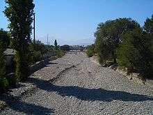
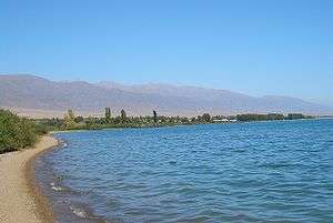
Because the high peaks function as moisture catchers, Kyrgyzstan is relatively well watered by the streams that descend from them. None of the rivers of Kyrgyzstan are navigable, however. The majority are small, rapid, runoff streams. Most of Kyrgyzstan's rivers are tributaries of the Syrdariya, which has its headwaters in the western Tian Shan along the Chinese border. Another large runoff system forms the Chui River, which arises in northern Kyrgyzstan, then flows northwest and disappears into the deserts of southern Kazakhstan. Ysyk-Köl is the second largest body of water in Central Asia, after the Aral Sea, but the saline lake has been shrinking steadily, and its mineral content has been rising gradually. Kyrgyzstan has a total of about 2,000 lakes with a total surface area of 7,000 km², mostly located at altitudes of 3,000 to 4,000 meters. Only the largest three, however, occupy more than 100 km² each. The second- and third-largest lakes, Songköl and Chatyr-Köl (the latter of which also is saline), are located in the Naryn River Basin.
Natural disasters have been frequent and varied. Overgrazing and deforestation of steep mountain slopes have increased the occurrence of mudslides and avalanches, which occasionally have swallowed entire villages. In August 1992, a severe earthquake left several thousand people homeless in the southwestern city of Jalal-Abad.
Climate

The country's climate is influenced chiefly by the mountains, Kyrgyzstan's position near the middle of the Eurasian landmass, and the absence of any body of water large enough to influence weather patterns. Those factors create a distinctly continental climate that has significant local variations. Although the mountains tend to collect clouds and block sunlight (reducing some narrow valleys at certain times of year to no more than three or four hours of sunlight per day), the country is generally sunny, receiving as much as 2,900 hours of sunlight per year in some areas. The same conditions also affect temperatures, which can vary significantly from place to place. In January the warmest average temperature (−4 °C or 25 °F) occurs around the southern city of Osh, and around Ysyk-Köl. The latter, which has a volume of 1,738 cubic kilometers (417 cu mi), does not freeze in winter. Indeed, its name means "hot lake" in Kyrgyz. The coldest temperatures are in mountain valleys. There, readings can fall to −30 °C (−22 °F) or lower; the record is −53.6 °C (−64.5 °F). The average temperature for July similarly varies from 27 °C (80.6 °F) in the Fergana Valley, where the record high is 44 °C (111 °F), to a low of −10 °C (14 °F) on the highest mountain peaks. Precipitation varies from 2,000 millimeters (78.7 in) per year in the mountains above the Fergana Valley to less than 100 millimeters (3.9 in) per year on the west bank of Ysyk-Köl.
Environmental issues
Kyrgyzstan has been spared many of the enormous environmental problems faced by its Central Asian neighbors, primarily because its designated roles in the Soviet system involved neither heavy industry nor large-scale cotton production. Also, the economic downturn of the early 1990s reduced some of the more serious effects of industrial and agricultural policy. Nevertheless, Kyrgyzstan has serious problems because of inefficient use and pollution of water resources, land degradation, and improper agricultural practices.
Natural hazards: prone to earthquakes, major flooding during the snow melt.
Water resources
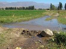
Although Kyrgyzstan has abundant water running through it, its water supply is determined by a post-Soviet sharing agreement among the five Central Asian republics. As in the Soviet era, Kyrgyzstan has the right to 25% of the water that originates in its territory, but the new agreement allows Turkmenistan and Uzbekistan unlimited use of the water that flows into them from Kyrgyzstan, with no compensation for the nation at the source. Kyrgyzstan uses the entire amount to which the agreement entitles it, but utilization is skewed heavily in favor of agricultural irrigation. During the Soviet era, Kyrgyzstan and Tajikistan shared their abundant water resources with Uzbekistan, Kazakhstan, and Turkmenistan during summer, and these three nations shared oil and gas with Kyrgyzstan and Tajikistan in winter. According to the International Crisis Group, the skewed system that is currently in place could cause irreversible regional destabilization, and needs to be dealt with by international actors to avoid a crisis in Central Asia.[3] In 1994 agriculture accounted for about 88% of total water consumption, compared with 8% by industry and 4% by municipal water distribution systems. According to World Bank experts, Kyrgyzstan has an adequate supply of high-quality water for future use, provided the resource is prudently managed.
Irrigation is extremely wasteful of water because the distribution infrastructure is old and poorly maintained. In 1993 only an estimated 5% of required maintenance expenditures was allocated. Overall, an estimated 70% of the nation's water supply network is in need of repair or replacement. The quality of drinking water from this aging system is poorly monitored—the water management staff has been cut drastically because of inadequate funds. Further, there is no money to buy new water disinfection equipment when it is needed. Some aquifers near industrial and mining centers have been contaminated by heavy metals, oils, and sanitary wastes. In addition, many localities rely on surface sources, making users vulnerable to agricultural runoff and livestock waste, which seep gradually downward from the surface. The areas of lowest water quality are the heavily populated regions of the Chui Valley and Osh and Jalal-Abad Regions, and areas along the rivers flowing into Ysyk-Köl.
In towns, wastewater collection provides about 70% of the water supply. Although towns have biological treatment equipment, as much as 50% of such equipment is rated as ineffective. The major sources of toxic waste in the water supply are the mercury mining combine at Haidarkan; the antimony mine at Kadamzai; the Kadzyi Sai uranium mine, which ceased extraction in 1967 but which continues to leach toxic materials into nearby Ysyk Köl; the Kara-Balta Uranium Recovery Plant; the Min Kush deposit of mine tailings; and the Kyrgyz Mining and Metallurgy Plant at Orlovka.
Land management
The most important problems in land use are soil erosion and salinization in improperly irrigated farmland. An estimated 60% of Kyrgyzstan's land is affected by topsoil loss, and 6% by salinization, both problems with more serious long-term than short-term effects. In 1994 the size of livestock herds averaged twice the carrying capacity of pasturage land, continuing the serious overgrazing problem and consequent soil erosion that began when the herds were at their peak in the late 1980s. Uncertain land tenure and overall financial insecurity have caused many private farmers to concentrate their capital in the traditional form—livestock—thus subjecting new land to the overgrazing problem.
The inherent land shortage in Kyrgyzstan is exacerbated by the flooding of agricultural areas for hydroelectric projects. The creation of Toktogul Reservoir on the Naryn River, for example, involved the flooding of 130 km² of fertile land. Such projects have the additional effect of constricting downstream water supply; Toktogul deprives the lower reaches of the Syr Darya in Uzbekistan and the Aral Sea Basin of substantial amounts of water. Because the Naryn Basin, where many hydroelectric projects are located, is very active seismically, flooding is also a danger should a dam be broken by an earthquake. Several plants are now in operation in zones where Richter Scale readings may reach eleven.
Environment - current issues: Nuclear waste, left behind by the Soviet Union in many open-air pits in hazardous locations. Water pollution; many people get their water directly from contaminated streams and wells; as a result, water-borne diseases are prevalent; increasing soil salinity from faulty irrigation practices. Illegal hunting of very rare species such as the snow leopard and the Marco Polo sheep.
Environment - international agreements:
party to: Air Pollution, Biodiversity, Desertification, Hazardous Wastes, Ozone Layer Protection, Wetlands
signed, but not ratified: none of the selected agreements
The Aral Sea
In response to the internationally recognized environmental crisis of the rapid desiccation of the Aral Sea, the five states sharing the Aral Sea Basin (Kazakhstan, Kyrgyzstan, Tajikistan, Turkmenistan, and Uzbekistan) are developing a strategy to end the crisis. The World Bank and agencies of the United Nations (UN) have developed an Aral Sea Program, the first stage of which is funded by the five countries and external donors. That stage has seven areas of focus, one of which—land and water management in the upper watersheds—is of primary concern to Kyrgyzstan. Among the conditions detrimental to the Aral Sea's environment are erosion from deforestation and overgrazing, contamination from poorly managed irrigation systems, and uncontrolled waste from mining and municipal effluents. Kyrgyzstan's National Environmental Action Plan (NEAP) has addressed these problems as part of its first-phase priorities in cooperation with the Aral Sea Program.
Environmental policy making

The NEAP, adopted in 1994, is the basic blueprint for environmental protection. The plan focuses on solving a small number of critical problems, collecting reliable information to aid in that process, and integrating environmental measures with economic and social development strategy. The initial planning period is to end in 1997. The main targets of that phase are inefficient water resource management, land degradation, overexploitation of forest reserves, loss of biodiversity, and pollution from inefficient mining and refining practices.
Because of severe budget constraints, most of the funds for NEAP operations come from international sources, including official institutions such as the World Bank and the Asian Development Bank and numerous international nongovernmental organizations. Implementation is guided by a committee of state ministers and by a NEAP Expert Working Group, both established in 1994 by executive order. A NEAP office in Bishkek was set up with funds from Switzerland.
The main environmental protection agency of the Kyrgyzstan government is the State Committee on Environmental Protection, still known by its Soviet-era acronym, Goskompriroda. Established by the old regime in 1988, the agency's post-Soviet responsibilities have been described in a series of decrees beginning in 1991. In 1994 the state committee had a central office in Bishkek, one branch in each of the seven regions, and a total staff of about 150 persons. Because of poorly defined lines of responsibility, administrative conflicts often occur between local and national authorities of Goskompriroda and between Goskompriroda and a second national agency, the Hydrometeorological Administration (Gidromet), which is the main monitoring agency for air, water, and soil quality. In general, the vertical hierarchy structure, a relic of Soviet times, has led to poor coordination and duplication of effort among environmental protection agencies.
Specially protected areas
A number of protected nature areas have been designated by the government of the republic. As of the end of 2004, they included:[4]
- 8 state nature reserves (zapovedniks), with the total area of 2,880 km²;
- 9 state nature national parks (2,760 km²);
- 10 forest, 23 floral, 18 geological, and 2 general-purpose protected areas (zakazniks), as well as 14 game reserves, with the total area of 3,250 km²;
- Lake Issyk Kul (so designated since 1998) and Sary-Chelek biosphere reserve (since 1978), together occupying the area of 282 km².[5]
Area and boundaries
Area:
total: 198,951 km²
land: 191,801 km²
water: 8,150 km²
Land boundaries:
total: 5,473 km
border countries: the People's Republic of China 1,063 km, Kazakhstan 1,212 km, Tajikistan 984 km, Uzbekistan 1,314 km
Coastline: 0 km (landlocked)
Maritime claims: none (landlocked)
Elevation extremes:
lowest point: Kara-Darya 132 m
highest point: Peak Jengish Chokusu 7,439 m
Resources and land use

Terrain:' peaks of Tien Shan and associated valleys and basins encompass entire nation
Natural resources: abundant hydropower; significant deposits of gold and rare earth metals; locally exploitable coal, petroleum, and natural gas; other deposits of nepheline, mercury, bismuth, lead, and zinc.
Land use:
arable land: 6.7%
permanent crops: 0.4%
permanent pasture: 48.3%
forest: 5.1%
other: 93.24% (2011)
note:
Kyrgyzstan has the world's largest natural growth walnut forest, Arslanbob, located in Jalal-Abad Region with an enormous variety of different genetic characteristics. It is believed that most of the world's walnut varieties derive from the original species still found here.
Irrigated land: 10,210 km² (2005)
Total renewable water resources: 23.62 km3 (2011)
References
| Wikimedia Commons has media related to Geography of Kyrgyzstan. |
- ↑ "The World Factbook: Kyrgyzstan" United States Central Intelligence Agency. Retrieved 12 January 2010
- 1 2 3 Kyrgyzstan Travel Map. Bishkek: Rarity Firm, LTD.
- ↑ International Crisis Group. "Water Pressures in Central Asia", CrisisGroup.org. 11 September 2014. Retrieved 7 October 2014.
- ↑ Особо охраняемые природные территории Кыргызской Республики (по состоянию на конец 2004 года) (Protected areas of the Kyrgyz Republic (as of the end of 2004)) (Russian)
- ↑ Biosphere Reserves in Kyrgyztan (sic)
 This article incorporates public domain material from the Library of Congress Country Studies website http://lcweb2.loc.gov/frd/cs/.
- This article incorporates public domain material from the CIA World Factbook website https://www.cia.gov/library/publications/the-world-factbook/index.html.