Geography of Gough Island

Geography of the Gough Island (also Gonçalo Álvares or mistakenly Diego Alvarez), consists of the remote, rugged terrain of the isolated island, which is situated between the tip of South Africa and South America.
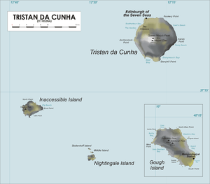
Gough Island is about 400 km (250 mi) southeast of the other islands in the Tristan da Cunha group, 2,700 km (1,700 mi) from Cape Town, and over 3,200 km (2,000 mi) east of the nearest point of South America. The island is roughly rectangular with a length of 13 km (8.1 mi) and a width of 7 kilometres (4.3 mi). It has an area of 91 km2 (35 sq mi) and rises to heights of over 900 m (3,000 ft) above sea level.[1][2][3]
A meteorological station, manned by seven members of the South African National Antarctic programme (SANAP), has operated at Glen since 1963.
Physical geography

One of the remotest islands in the world, Gough Island is in the South Atlantic Ocean. While the central part of the island is a plateau, the western part has a highland with the highest peaks and cliffs rising to 1,500 ft (460 m). Glens cut deep into the inland from the northern and eastern sides.[2] Geological formations on the island are of volcanic origin.[2]
Topographic features include its highest peak, Edinburgh Peak (2,986 ft (910 m)), as well as Hags Tooth, Mount Rowett, Sea Elephant Bay, Quest Bay, and Hawkins Bay.[1][2]
Surrounding Gough are small satellite islands and rocks, such as Southwest Island, Saddle Island (to the South), Tristiana Rock, Isolda Rock (West), Round Island, Cone Island, Lot's Wife, Church Rock (North), Penguin Island (Northeast), and The Admirals (East).[1]
The average temperature is 12 °C (54 °F) while the average rainfall is 3,000 millimetres (120 in). Snow occurs in the highlands.[4]
Ecological significance
Gough Island was inscribed by UNESCO as a World Heritage Site in 1995,[2] for its "marine ecosystems in the cool temperate zone."[3] The island "has been described as the most important seabird island in the world".[5]
Human geography
The Portuguese discovered Gough Island in 1505 but landed on the island only in 1675. It was rediscovered in 1732 by naval captain Charles Gough.[6] The explorers were followed by sealers who exploited seals till the early 19th century.[2][3] There was a brief period of human occupation for two years from 1936-38 when farming was done to hunt for birds, their eggs, and to extract driftwood, guano and apples.[3]
Since then, naval and scientific expeditions have also made brief visits to the island. The island was annexed by the United Kingdom in 1938. Its present status is as a territory of the Dependency of Tristan da Cunha under the Crown Colony of St Helena.[2]
References
- 1 2 3 "Gough Island". Sanap.ac.za. Retrieved 26 August 2013.
- 1 2 3 4 5 6 7 "Gough Island Scientific Survey, 1955-56". Scott Polar Research Institute University of Cambridge. Retrieved 25 August 2013.
- 1 2 3 4 "Gough and Inaccessible Islands". UNESCO Organization. Retrieved 26 August 2013.
- ↑ Gillespie & Clague 2009, p. 930.
- ↑ Riffenburgh 2007, p. 471.
- ↑ Smallman 2003, p. 153.
- Bibliography
- Gillespie, Rosemary G.; Clague, D. A. (2009). Encyclopedia of Islands. University of California Press. ISBN 978-0-520-25649-1.
- Riffenburgh, Beau (January 2007). Encyclopedia of the Antarctic. Routledge. ISBN 978-0-415-97024-2.
- Smallman, David L. (2003). Quincentenary: A Story of St Helena, 1502-2002. Hypatia Publications. ISBN 978-1-872229-47-8.
Coordinates: 40°19′05″S 9°56′07″W / 40.3181°S 9.9353°W