Geneston
| Geneston | ||
|---|---|---|
|
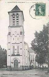
The church in Geneston, in the early 20th century | ||
| ||
 Geneston | ||
|
Location within Pays de la Loire region  Geneston | ||
| Coordinates: 47°03′23″N 1°30′41″W / 47.0564°N 1.5114°WCoordinates: 47°03′23″N 1°30′41″W / 47.0564°N 1.5114°W | ||
| Country | France | |
| Region | Pays de la Loire | |
| Department | Loire-Atlantique | |
| Arrondissement | Nantes | |
| Canton | Aigrefeuille-sur-Maine | |
| Intercommunality | Grand Lieu | |
| Government | ||
| • Mayor (2008–2014) | Gérard Gouraud | |
| Area1 | 8.04 km2 (3.10 sq mi) | |
| Population (2006)2 | 3,233 | |
| • Density | 400/km2 (1,000/sq mi) | |
| Time zone | CET (UTC+1) | |
| • Summer (DST) | CEST (UTC+2) | |
| INSEE/Postal code | 44223 / 44140 | |
| Elevation | 14–39 m (46–128 ft) | |
|
1 French Land Register data, which excludes lakes, ponds, glaciers > 1 km² (0.386 sq mi or 247 acres) and river estuaries. 2 Population without double counting: residents of multiple communes (e.g., students and military personnel) only counted once. | ||
.svg.png)
Geneston is a commune in the Loire-Atlantique department in western France.
Notable citizens
- Philibert Delorme (1510–1570), king's architect during the reign of François Ier and Henri II. On official papers, he was called "Abbé de Geneston" (Priest of Geneston).
- Mgr Rogatien Martin (1849–1912), born in Geneston. He was a religious in the Marquesas Islands.
- Jean-Baptiste Legeay (1897–1943), member of the monastic order Brother of Ploërmel, born in Geneston, resistant during the Second World War and killed in Cologne, Germany
See also
| Wikimedia Commons has media related to Geneston. |
This article is issued from Wikipedia - version of the 2/5/2015. The text is available under the Creative Commons Attribution/Share Alike but additional terms may apply for the media files.