Gartell Light Railway
 | |
| Locale | England |
|---|---|
| Dates of operation | 1990–Present |
| Track gauge | 2 ft (610 mm) |
| Length | 3⁄4 mile (1.2 km) |
| Headquarters | Templecombe |
| Gartell Light Railway | ||||||||||||||||||||||||||||||||||||||||||||||||||||||||||||||||||
|---|---|---|---|---|---|---|---|---|---|---|---|---|---|---|---|---|---|---|---|---|---|---|---|---|---|---|---|---|---|---|---|---|---|---|---|---|---|---|---|---|---|---|---|---|---|---|---|---|---|---|---|---|---|---|---|---|---|---|---|---|---|---|---|---|---|---|
Legend | ||||||||||||||||||||||||||||||||||||||||||||||||||||||||||||||||||
| ||||||||||||||||||||||||||||||||||||||||||||||||||||||||||||||||||
The Gartell Light Railway is a privately run narrow gauge edutainment railway located at Yenston in the Blackmore Vale, south of Templecombe, in Somerset, England. It operates a 2 ft (610 mm) narrow gauge railway running for 3⁄4 mile (1.2 km), partly along the track of the old Somerset and Dorset Joint Railway.[1] The railway has 4 stations - Common Lane, Pinesway Junction, Park Lane and Tower View.
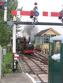
The railway is controlled using a comprehensive signalling system operated from two signalboxes - Common lane and Pinesway Junction. Both signalboxes control a mix of semaphore and colour light signals with mechanically operated points.[2]
The railway is open to the public on selected dates through the year when it normally operates an intensive 3 train operation with departures from Common Lane station every 20 minutes through the day between 10:30 and 16:30.
The route of the GLR
- Park Lane
- Pinesway Junction
- Tower View
Locomotives
| Number | Name | Builder | Type | Date | Works number | Notes |
|---|---|---|---|---|---|---|
| 1 | AMANDA | Gartell Light Railway | Bo-BoDH | 2000 | Ex Southend Pier Railway, rebuilt on the railway | |
| 2 | ANDREW | Baguley-Drewry | 4wDH | 1973 | 3699 | Acquired in 2007 |
| 5 | ALISON | Alan Keef | 4wDH | 1993 | 10[3] | |
| 6 | Mr. G | North Dorset Locomotive Works | 0-4-2T | 1998 | 698[3] | Newly built for the line, based on the design of W.G. Bagnall locomotive Polar Bear |
| 9 | Jean | Alan White | 0-4-0T+T | 2008 | [4] |
See also
References
- ↑ "Gartell Light Railway". Steam Heritage. Retrieved 15 September 2016.
- ↑ "Gartell Light Railway". Steam Railway Lines. Retrieved 15 September 2016.
- 1 2 Industrial Railway Society (2007). Industrial Locomotives (14EL). Industrial Railway Society. ISBN 0-901906-39-5.
- ↑ Gartell Light Railway (2008). Official Guide 2008. Gartell Light Railway.
- Thomas, Cliff (2002). The Narrow Gauge in Britain & Ireland. Atlantic Publishers. ISBN 1-902827-05-8.
External links
| Wikimedia Commons has media related to Gartell Light Railway. |
Coordinates: 50°59′41″N 2°24′10″W / 50.994838°N 2.402868°W