Garratt Lane
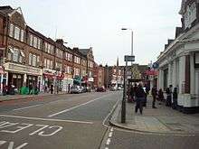
Garratt Lane is a long street (numbered to 1085) in the London Borough of Wandsworth, part of the A217 road. It connects Wandsworth High Street to Tooting Broadway and is approximately four kilometres long. It passes through Earlsfield and Summerstown, before their late 19th century development, fields of Wandsworth.
Description
Garratt Lane has mixed usage along its length. In the north it contains newly developed stores including a large single-storey shopping mall with parking above. The stretch between Allfarthing Lane and Burntwood Lane is mainly diverse shophouses including a few professional services. The southern portion is mainly residential, although around Summertown there are a few light industries and the Wimbledon Stadium.
The southernmost part of Garratt Lane is unusual in that two parallel streets exchanged names. The original Garratt Lane was a narrower street than Garratt Terrace, which was the main connection to Tooting Broadway. Many people mistakenly called it Garratt Lane, so it was agreed to exchange the names.
Garrat Elections

Most large public houses have survived along Garratt Lane, including The Old Sergeant and the Leather Bottle, both of which date to the 18th century. The latter figured in the mock Garrat Elections of the late 18th century, which were featured in the play The Mayor of Garratt by Samuel Foote.[1]
Transportation
Garratt Lane is one of three major north-south routes in south-west Inner London, i.e. between the Lambeth/Southwark south bank areas and the gradual widening and receiving of local roads to the arterial A3, west of Wandsworth. The Lane follows a bank of the River Wandle so has quite a consistent rise as with the parallel A218 on the higher, western bank. Industries grew up in the 18th and 19th centuries along this east bank, which led to its prominence. A 1786 map[2] shows and names Garratt Lane running approximately on its present route. This map also shows two lanes that intersect named: Half Farthing (now Allfarthing) and Burnt Wood (now one word). The sub-settlement on its length was Garratt Green, Wandsworth.
In 1803 the first commercial railway in Britain was opened along much of the northern section. This was the Surrey Iron Railway which connected the Thames at Wandsworth with these industries, and those in Merton and Croydon. No sign remains of the railway which was horse-drawn.
Public transport in the form of horse buses was placed on the street in the latter part of the 19th century, and in 1903 the London County Council (LCC) extended and electrified the tramways. The trams started at the Thames near Westminster and went west and southwest on three route, one through Clapham Junction to Wandsworth, another through Brixton to Streatham, and one through Balham to Wimbledon. The routes through Garratt Lane connected all three with the focal point being Tooting.
When the London Passenger Transport Board was formed in 1933 to control all of London's transport, route 12 (from Tooting to London Bridge via Wandsworth & Battersea) and route 30 (from Tooting to Shepherds Bush via Putney) ran the length of Garratt Lane. These routes were transformed to trolleybus (612 and 630) routes in 1937. Again the mode of transport changed in 1960s, with buses (No 44 & 220 (later replaced by the 270) respectively) replacing the trolleybuses. This pattern of change occurred throughout London although now there is a tendency towards tramway (or street railways) existing in Croydon and proposed elsewhere.
The railway crosses Garratt Lane at Earlsfield Station and the nearest Underground station is Tooting Broadway just opposite the south end of Garratt Lane.
Buildings listed by the Borough
There are four listed properties on Garratt Lane:
- The Old Court House near Wandsworth High Street is set back from Garratt Lane by a small public garden. It held the Wandsworth Museum until 2008, when it was converted into a public library.
- St Andrews Church is in Earlsfield and is the Church of England parish church
- The Leather Bottle Public House, at Summers Green, has historic connections. It is documented as being in existence in 1745, but is probably older. Its appearance has changed little over the last 150 years. One of the engravings by Valentine Green, shows election of a Mayor of Garratt (1781) in front of the Leather Bottle.
- St Clement Danes Almshouses is also known as Diprose Lodge. It is within a walled estate in Earlsfield. The Almshouses are now owned and operated by the Borough of Merton.
References
- ↑ The Mayor of Garratt Google books. Retrieved 2014-11-12
- ↑ Carey's map of The Environs of London sheet 34
- "A History of London Transport" (2 volumes) by T G Barker and M Robbins - published by George Allen and Unwin 1963
- "The Times London Historic Atlas" edited by Hugh Clout - Published by The Times of London ISBN 0-7230-0342-4
- "The Streets of London" by S Fairfield - published by Papermac ISBN 0-333-28649-9
- "London Transport Tramways Handbook" by D W Willoughby & E K Oakley - published by the authors ISBN 0-903479-00-1
Coordinates: 51°26′21″N 0°11′12″W / 51.4392°N 0.1868°W