Garmond, Aberdeenshire
Coordinates: 57°33′42″N 2°19′36″W / 57.56167°N 2.32667°W Garmond (Scottish Gaelic: Garbh Mhon(adh)) is a linear village in Monquhitter Parish which is located in Aberdeenshire, Scotland.[1][2] It was founded c.1760. Like the neighbouring villages of Cuminestown and New Byth, the residential part is located on the crest of a hill, the valley below being largely given over to farmland.
"The Garmond" is 1 mile North of Cuminestown and 7 miles East of Turriff.
References
- ↑ Ordnance Survey: Landranger map sheet 29 Banff & Huntly (Portsoy & Turriff) (Map). Ordnance Survey. 2014. ISBN 9780319231043.
- ↑ "Ordnance Survey: 1:50,000 Scale Gazetteer" (csv (download)). www.ordnancesurvey.co.uk. Ordnance Survey. 1 January 2016. Retrieved 18 February 2016.
- The geographic coordinates are from the Ordnance Survey.
| Wikimedia Commons has media related to Garmond, Aberdeenshire. |
Settlements and places of interest in Formartine, Aberdeenshire | ||
|---|---|---|
| Primary settlements | 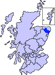 | |
| Other settlements | ||
| Places of interest | ||
Areas and primary settlements in Aberdeenshire (see also: Aberdeen City) | ||
|---|---|---|
| in Banff and Buchan |  | |
| in Buchan | ||
| in Formartine | ||
| in Garioch | ||
| in Kincardine and Mearns | ||
| in Marr | ||
This article is issued from Wikipedia - version of the 2/21/2016. The text is available under the Creative Commons Attribution/Share Alike but additional terms may apply for the media files.