Garibaldi Lake
| Garibaldi Lake | |
|---|---|
 Garibaldi Lake and the north face of Mount Garibaldi, looking south from Panorama Ridge at 6,900 ft (2,100 m). | |
| Location | British Columbia |
| Coordinates | 49°55′30″N 123°0′36″W / 49.92500°N 123.01000°WCoordinates: 49°55′30″N 123°0′36″W / 49.92500°N 123.01000°W |
| Primary inflows | Mimulus Creek, Sentinel Glacier, Sphinx Glacier |
| Primary outflows | Rubble Creek |
| Basin countries | Canada |
| Surface area | 9.94 km² (2460 acres) |
| Average depth | 119 m (390 ft) |
| Max. depth | 258.7 m (849 ft) |
| Surface elevation | 1,484 m (4,869 ft) |
| Islands | Battleship Islands |
| Settlements | No |
Garibaldi Lake is a turquoise-coloured alpine lake in British Columbia, Canada, located 37 km (23 mi) north of Squamish and 19 km (12 mi) south of Whistler. The lake lies within Garibaldi Provincial Park, which features mountains, glaciers, trails, forests, flowers, meadows, waterfalls. The park is a wildlife protected area.

Geology


Garibaldi Lake lies in a deep subalpine basin, with its surface at nearly 1,500 m (4,900 ft) above sea level and a depth exceeding 250 m (800 ft). It is almost entirely surrounded by mountains except at its northwestern tip, with volcanoes along the north, west, and south sides and non-volcanic peaks along the northeast and eastern shores. Lava flows from the volcanoes of Mount Price and Clinker Peak to the south blocked the ancestral valley, damming the waters of the lake behind the lava formation known as The Barrier. This lava dam is over 300 m (1,000 ft) in thickness and about 2 km (1.2 mi) wide where it impounds the lake. A series of lava outcrops along the northwestern shore of the lake form the numerous tiny Battleship Islands, several of which have been connected to the shore by simple man-made stone causeways.
The turquoise colour of the lake's water is due to glacial flour suspended in the meltwater from its two primary inflows, the large Sphinx Glacier to the east and the Sentinel Glacier to the south on the flanks of Mount Garibaldi. Throughout most of the year, outflow from Garibaldi Lake occurs only via seepage through cracks in the lava dam, with Rubble Creek appearing from springs at the base of The Barrier. During spring snowmelt, outflow is sufficient for surface drainage to occur via a shallow channel across the lava flow, into Lesser Garibaldi Lake and Barrier Lake about 1.6 km (1 mi) west of the main lake's shore.
Geohazards
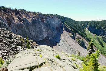
The unstable lava formation of The Barrier has in the past unleashed several debris flows in the area below the lake, most recently in 1855-56 forming a large boulder field which gives Rubble Creek its name. Concerns about the Barrier's instability due to volcanic, tectonic, or heavy rainfall activity prompted the provincial government to declare the area immediately below it unsafe for human habitation in 1981. This led to the evacuation of the nearby village of Garibaldi, British Columbia, and the relocation of residents to new recreational subdivisions away from the hazard zone. Should the Barrier completely collapse, Garibaldi Lake would be entirely released and downstream damage in the Cheakamus and Squamish Rivers would be considerable, including major damage to the town of Squamish and possibly an impact-wave on the waters of Howe Sound that would reach Vancouver Island.
Recreation
All recreational activities in the area are governed by the regulations of Garibaldi Provincial Park. Primary access to the lake is via the 9 km (5.5 mi) long Garibaldi Lake Trail, which gains approximately 920 m (3,020 ft) of elevation from the Rubble Creek Trailhead. There are campgrounds and day-use shelters on the west shore of Garibaldi Lake, and also farther northwest at Taylor Meadows. During the summer, access to the eastern end of the lake is severely limited, since no trails have been constructed along the steep and unstable slopes which plunge directly into the lake. During winter, the lake is typically frozen from late December to late April, allowing backcountry skiers and snowshoers to easily reach the far shore. A pair of small alpine huts are located in Sphinx Bay on the eastern shore and Sentinel Bay at the southeastern tip of the lake.

See also
References
- Mathews, W. H. (1956). "Physical limnology and sedimentation in a glacial lake [Garibaldi Lake]". Geological Society of America Bulletin. 67 (5): 537–552. Bibcode:1956GSAB...67..537M. doi:10.1130/0016-7606(1956)67[537:PLASIA]2.0.CO;2.
- Mathews, W. H. (August 1, 1952). "Ice-dammed lavas from Clinker Mountain, southwestern British Columbia". American Journal of Science. 250 (8): 553–565. doi:10.2475/ajs.250.8.553.
- Moore, D. P.; Mathews, W. H. (1978). "The Rubble Creek landslide, southwestern British Columbia". Canadian Journal of Earth Sciences. 15 (7): 1039–1052. Bibcode:1978CaJES..15.1039M. doi:10.1139/e78-112.
- Mathews, William H. (1975). Garibaldi Geology: A popular guide to the geology of the Garibaldi Lake area. Geological Association of Canada.
- Mathews, Bill; Monger, Jim (2005). Roadside Geology of Southern British Columbia. Mountain Press Publishing Company. ISBN 0-87842-503-9.
- Wood, Charles A.; Jürgen Kienle, eds. (1990). Volcanoes of North America. Cambridge University Press. ISBN 0-521-43811-X.
- Harris, Stephen L. (2005). Fire Mountains of the West: The Cascade and Mono Lake Volcanoes (3rd ed.). Mountain Press Publishing Company. ISBN 0-87842-511-X.
External links
| Wikimedia Commons has media related to Garibaldi Lake. |
- BC Parks: Garibaldi Provincial Park
- LiveTrails: Garibaldi Lake
- Outdoor Vancouver: Garibaldi Lake Hiking Trail