Gardiners Creek
| Gardiners Creek | |
|---|---|
 Gardiners Creek through Blackburn | |
| Country | Australia |
| Basin | |
| Basin size | Eastern suburbs of Melbourne |
| Physical characteristics | |
| Length | 30 km (19 mi) |
Gardiners Creek, originally known as Kooyongkoot Creek,[1] is a waterway in the eastern suburbs of Melbourne, and part of the Yarra River catchment.
In a few sparse locations remnant riparian bushland survives, however the majority of its length has been heavily urbanised, and the creek has been degraded in much the same way as other Melbourne eastern suburban waterways such as the Mullum Mullum Creek and Koonung Creek. The Gardiners Creek Trail follows the creek for most of its length.
Naming
The creek's original name was Kooyongkoot, from the Woiwurrung language of the indigenous Australian Wurundjeri-Baluk group,[1] which translates to 'haunt of the waterfowl'. The creek's current name was given in honour of early Melbourne land speculator and banker, John Gardiner, who settled near the junction of Kooyongkoot Creek and the Yarra River in 1836.[2]
Geography
Course
Gardiners Creek is over 30 km (19 mi) in length.
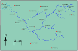
The creek originates in the suburb of Blackburn, where many small creeks and gullies converge around Blackburn Lake. It then flows southwest through Box Hill South, Burwood, and Ashwood. Approximately at its junction with Scotchmans Creek in Malvern East it turns northwest, then continues through Ashburton, Glen Iris, Malvern, and Kooyong, before finally flowing into the Yarra River in Hawthorn.[3]
Tributaries
- Unnamed watercourse through Blackburn/Forest Hill
- Unnamed watercourse through Wurundjeri Wetlands
- Damper Creek
- Unnamed watercourse through Ashwood/Mount Waverley
- Murrumbeena Creek
- Scotchmans Creek
- Hercules Creek
- Back Creek
Parklands
Upstream to downstream:[3]
- Blackburn Lake Sanctuary (Blackburn)
- Blackburn Creeklands Reserve (Blackburn)
- Furness Park (Blackburn)
- Kalang Park (Blackburn)
- Blacks Walk (Blackburn)
- R.H.L. Sparks Reserve (creek piped underground) (Box Hill)
- Wembley Park (Box Hill South)
- Box Hill Golf Club (Box Hill South)
- Gardiners Creek Reserve (Burwood)
- Local History Park (Burwood)
- Gardiners Reserve (Burwood)
- Ashwood Reserve (Ashwood)
- Markham Reserve (Ashburton)
- Malvern Valley Public Golf Course (Malvern East)
- Darling Park (Malvern East)
- Dorothy Laver Reserve (Glen Iris)
- Dorothy Laver Reserve West (Glen Iris)
- Glen Iris Wetlands (Glen Iris)
- Glen Iris Park (Glen Iris)
- Muswell Bend Park (Glen Iris)
- Glenburn Bend Park (Glen Iris)
- Nettleton Park Reserve (Glen Iris)
- Kyarra Park (separated since freeway construction) (Glen Iris)
- Howard Dawson Reserve (Glen Iris)
- Burke Road South Reserve (Glen Iris)
- Gardiner Park (separated since freeway construction) (Gardiner)
- Tooronga Park (separated since freeway construction) (Malvern)
- Patterson Reserve (Hawthorn)
- H.A. Smith Reserve (separated since freeway construction) (Hawthorn)
- Kooyong Park (Kooyong)
- Kooyong Stadium (Kooyong)
Transport
The Gardiners Creek Trail, a shared use cycling and pedestrian track, follows the general course of Gardiners Creek from Box Hill's boundary with Blackburn to the Yarra River, where a bridge over the river links it to the Main Yarra Trail.[3]
The Monash Freeway/CityLink follow the Gardiners Creek valley from Malvern East to the Yarra River.[3]
Crossings
Upstream to downstream:[3]
- Central Road
- Lake Road and Weir (Blackburn Lake)
- Jeffery Street
- Blackburn Road
- Main Street
- Blackburn Creeklands Footbridges
- Pakenham Street
- Middleborough Road
- Canterbury Road
- Station Street
- Burwood Highway
- Highbury Road
- High Street Road
- Warrigal Road
- Winton Road
- Darling Park Footbridge
- Dunlop Street
- Glen Iris Park Footbridge
- High Street
- Nettleton Park Footbridge
- Great Valley Road
- Burke Road
- Tooronga Road
- Toorak Road
- Monash Freeway/CityLink
- Glenferrie Road
See also
References
- 1 2 "Gardiners Creek: Aboriginal settlement". Official website. City of Boroondara. Retrieved 11 February 2011.
- ↑ "Gardiners Creek: John Gardiner". Official website. City of Boroondara. Retrieved 11 February 2011.
- 1 2 3 4 5 Melway: Greater Melbourne Street Directory 2007. Mt Waverley, Victoria: Melway Publishing Pty Ltd. 2006. ISBN 0-909439-24-9.
External links
- Melbourne Water page on Gardiners Creek
- Friends of Gardiners Creek
- Boroondara Council History of the Creek
- Blackburn Creeklands
Coordinates: 37°50′S 145°02′E / 37.833°S 145.033°E
Waterways of the Greater Melbourne catchment, Victoria, Australia | |
|---|---|
| Ocean inlets, harbours and bays | |
| Rivers | |
| Creeks |
|
| Lagoons and lakes | |
| Adjoining rivers and bays | |
| |
| Port Phillip sub-catchment |
|
|---|---|
| Western Port sub-catchment | |
| |