Garden Home–Whitford, Oregon
| Garden Home-Whitford, Oregon | |
|---|---|
| CDP | |
|
Recreation Center in Garden Home | |
 Location of Garden Home-Whitford, Oregon | |
| Coordinates: 45°27′50″N 122°45′32″W / 45.46389°N 122.75889°WCoordinates: 45°27′50″N 122°45′32″W / 45.46389°N 122.75889°W | |
| Country | United States |
| State | Oregon |
| County | Washington |
| Area | |
| • Total | 1.9 sq mi (4.9 km2) |
| • Land | 1.9 sq mi (4.9 km2) |
| • Water | 0.0 sq mi (0.0 km2) |
| Elevation | 259 ft (79 m) |
| Population (2010) | |
| • Total | 6,674 |
| • Density | 3,656.9/sq mi (1,411.9/km2) |
| Time zone | Pacific (PST) (UTC-8) |
| • Summer (DST) | PDT (UTC-7) |
| FIPS code | 41-27825[1] |

Garden Home-Whitford is a census-designated place (CDP)[2] consisting of the neighborhoods of Garden Home and the smaller Whitford area in Washington County, Oregon, United States. They are located in the southwest hills of Portland, near Beaverton. As of the 2000 census, the CDP population was 6,931.
History
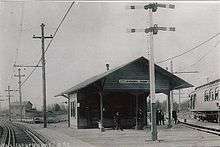
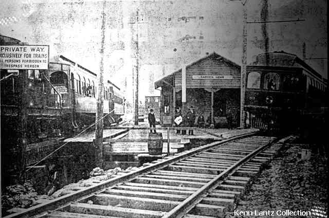
Garden Home post office was established in 1882.[4] Garden Home was an established community when the Oregon Electric Railway was built at the beginning of the 20th century, which named a depot on the line for the community.[5] Whitford was a station on the same line, located at the present-day intersection of Allen Road and Scholls Ferry Road (Oregon Route 210); the name was created by combining the names of W. A. White and A.C. Bedford, New York investors who were directors of the railway.
Whitford station closed when the railway stopped running around 1920, and unlike Garden Home, which became the name of a Portland suburb, Whitford exists today primarily as the name of a Beaverton middle school.
Geography
According to the United States Census Bureau, the CDP has a total area of 1.9 square miles (4.9 km2), none of which is covered with water.
Demographics
As of the census[1] of 2000, there were 6,931 people, 3,048 households, and 1,834 families residing in the CDP. The population density was 3,656.9 people per square mile (1,408.5/km²). There were 3,175 housing units at an average density of 1,675.2/sq mi (645.2/km²). The racial makeup of the CDP was 91.79% White, 3.17% Asian, 0.75% African American, 0.40% Native American, 0.16% Pacific Islander, 0.72% from other races, and 3.00% from two or more races. Hispanic or Latino of any race were 3.20% of the population.
There were 3,048 households out of which 26.3% had children under the age of 18 living with them, 47.8% were married couples living together, 9.3% had a female householder with no husband present, and 39.8% were non-families. 30.6% of all households were made up of individuals and 7.2% had someone living alone who was 65 years of age or older. The average household size was 2.26 and the average family size was 2.83.

The population in the CDP is spread out with 21.1% under the age of 18, 6.5% from 18 to 24, 31.6% from 25 to 44, 27.7% from 45 to 64, and 13.1% who were 65 years of age or older. The median age was 40 years. For every 100 females there were 92.1 males. For every 100 females age 18 and over, there were 89.5 males.
The median income for a household in the CDP was $52,321, and the median income for a family was $60,703. Males had a median income of $45,220 versus $35,000 for females. The per capita income for the CDP was $28,681. About 2.5% of families and 5.1% of the population were below the poverty line, including 4.5% of those under age 18 and 2.7% of those age 65 or over.
Government
Fire protection and EMS services are provided through Tualatin Valley Fire and Rescue.[6]
References
- 1 2 "American FactFinder". United States Census Bureau. Retrieved 2008-01-31.
- ↑ "Garden Home-Whitford". Geographic Names Information System. United States Geological Survey. Retrieved 2012-01-13.
- ↑ http://apps.beavertonoregon.gov/HistoricPhotos/photo_addinfo.aspx?id=245
- ↑ McArthur, Lewis A.; Lewis L. McArthur (2003) [1928]. Oregon Geographic Names (7th ed.). Portland, Oregon: Oregon Historical Society Press. p. 391. ISBN 0-87595-277-1.
- ↑ "PDX History – Oregon Electric Railway". December 6, 2008. Retrieved December 20, 2009.
- ↑ "About TVF&R". Tualatin Valley Fire & Rescue. Retrieved 13 March 2014.
External links
 Media related to Garden Home, Oregon at Wikimedia Commons
- Garden Home Recreation Center
- Garden Home Community Library
- Photos of Oregon Electric Railway, including a photo of the Garden Home depot
- History of Whitford from a Beaverton school website
- Garden Home History Project
Municipalities and communities of Washington County, Oregon, United States | ||
|---|---|---|
| Cities |  | |
| CDPs | ||
| Unincorporated communities |
| |
| Ghost towns | ||
| Footnotes | ‡This populated place also has portions in an adjacent county or counties | |