Garachico
| Garachico | |||
|---|---|---|---|
| Municipality | |||
| |||
 Municipal location in Tenerife | |||
 Garachico Location of the town in Tenerife | |||
| Coordinates: 28°22′20″N 16°45′50″W / 28.37222°N 16.76389°WCoordinates: 28°22′20″N 16°45′50″W / 28.37222°N 16.76389°W | |||
| Country |
| ||
| Autonomous community |
| ||
| Province |
| ||
| Island |
| ||
| Area[1] | |||
| • Total | 29.28 km2 (11.31 sq mi) | ||
| Elevation[1] | 10 m (30 ft) | ||
| Population (2009)[2] | |||
| • Total | 5,416 | ||
| • Density | 180/km2 (480/sq mi) | ||
| Climate | Csa | ||


Garachico is a municipality and town on the northern coast of Tenerife, about 52 km West of the capital Santa Cruz de Tenerife, 50 km from Tenerife North Airport and 67 km from Tenerife South Airport. The town itself nestles below a 500m+ (1500 ft) cliff. Garachico and the surrounding area is arguably the least spoilt coastal area of Tenerife, and is in sharp contrast to areas such as Playa de las Americas. It is still very Spanish in character, and a Spanish phrasebook is advisable for non-Spanish speaking visitors.
There is no beach worth mentioning; the coastline is essentially volcanic debris, but this does give the town its charm and a reason to visit it. Near the old port, there has been considerable recent effort to landscape the shoreline. Many paths have been laid as crazy paving, and some natural rock pools made into swimming pools. Rod and line fishing is also evident. However, outside of these rock pools, the Atlantic swell makes swimming inadvisable for all but the very brave. A municipal swimming pool has been built, next to the natural rock pools.
The town itself is low rise and a mixture of renovated and in need of renovation buildings, and includes several large courtyard style houses There are many hidden shops that appear to be private houses until they open their doors and display their wares. Most streets are cobbled and narrow, with cars parked on one side. Next to the main church there is a big open square, with a bar under the bandstand. An old monastery is adjacent to the main square and open to the public. The municipal authorities have clearly tried to show off their history and many buildings have English, Spanish and German noticeboards, explaining their history. On the front, an old water-mill houses a small museum, as does an old harbourside fort. There are many family run restaurants, with the best hidden away in the back streets.
The May 5, 1706 eruption originating from the northwest rift zone was a major event in the town's history. Prior to then, Garachico was an important port exporting Malmsey Wine and other local produce. However, a several-week-long eruption poured lava into the old bay and effectively destroyed the town's livelihood.
Garachico has always taken care of its environment and protected the most diverse cultural manifestations. For all these reasons, the Spanish government awarded the town the Gold Medal of Fine Arts, which was presented in 1980 by His Majesty the King.
Pictures
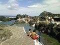 "piscinas"
 old buildings
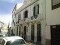 tiny street
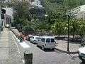 small park
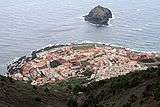 view
view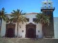 old buildings
 view
view street
References
- 1 2 "SUPERFICIE, PERÍMETRO Y ALTITUD DE LOS MUNICIPIOS DE CANARIAS." (in Spanish). Instituto Canario de Estadística (ISTAC).
- ↑ "Población en Canarias. Tenerife. 1-1-2009." (in Spanish). Instituto Canario de Estadística (ISTAC).
See also
| Wikimedia Commons has media related to Garachico. |
 |
Atlantic Ocean | | ||
| Los Silos | |
Icod de los Vinos | ||
| ||||
| | ||||
| El Tanque | Santiago del Teide |