Gaps of the Allegheny

• The maps on this page also are showing the nearby PRR Horseshoe Curve which crosses watercourses cutting three other gaps. GNIS software shows the Gap with the indicated 'A' marker well below the mouth of Kittanning Run.
• The Kittanning Gap name likely signifies a 'choice way' of climbing the escarpment to wagons or mule trains on the way to the west side of the Allegheny Mountains and Kittanning, PA. Taking a right through the gap to climb up the escarpment was a bit easier than either steep narrow creek beds straight ahead. This was one alternative routing through the area along what the 19th century would call the Kittanning Path.
The travel story gets worse. Counting the Hudson Valley north of the Catskills in New York and the southern end of the chain on the Georgian plains, there are exactly three narrow areas where water gaps allowed climbing up to mountain passes allowing passage across the mountains was possible to animal pulled transport vehicles.

• The dark trace forming an hairpin turn directly below that marker is the Pennsylvania Railroad's famous Horseshoe Curve.


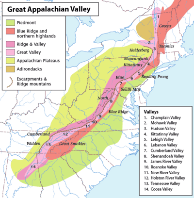
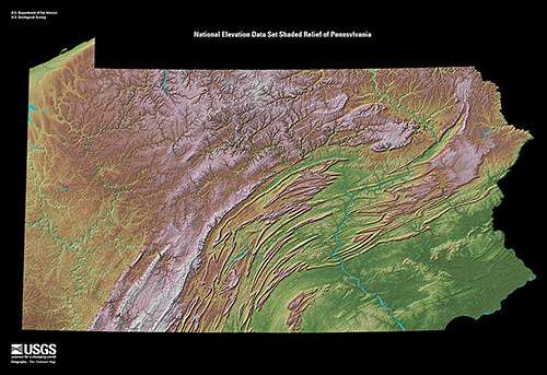
The gaps of the Allegheny meaning gaps in the Allegheny Ridge (now given the technical name Allegheny Front) in west-central Pennsylvania is series of escarpment eroding water gaps (notches or small valleys) along the saddle between two higher barrier ridgelines in the eastern face atop the Allegheny Ridge or Allegheny Front escarpment. The gaps, formed by small streams provided several usable incline planes or ramps connecting the eastern river valley lowlands to the highlands atop the plateau to the west and north that would otherwise have been unnavigable by animal powered wagons before the mid-1930s. As the map at right indicates, there were but five ways west from the eastern seaboard (colonies) to beyond the Appalachians barrier ridges. The gaps in the Allegheny, all west of present-day Hollidaysburg and Altoona
The terms gaps of the Allegheny and the formal geology term the Allegheny Front are from two different disciplines. The former used by historians describing the local measures taken during the French and Indian War and Amerindian territories before the United States Constitution, or discussing the transport network east to west before the 1930s depression's public works projects drove hundreds of roads into the mountains. These low water gaps of the Allegheny are located in a arc in the depression between higher barrier ridgelines, a family or succession of half-mountain passes letting out in a similar series of water courses, albeit rising more gradually from the west where the depressed upland was caused by the weight of the immense plateau glacier that flattened the Appalachian Plateau long ago. In the days before academia began traveling to fancy conferences in vacation cities and formed committees to standardize terms, place names were generally applied locally, copied by the USGS making regional maps, and in that era the last escarpment rising to the Allegheny Plateau was generally known as 'Allegheny Mountain' or the 'Allegheny Ridge' or just 'The Allegheny'. The modern term of art, the Allegheny Front, was coined by the physical geologists and other earth scientists interested in geomorphology reasoning out the processes that make one landscape terrain different from another in time, cause and space.
Greater Geology
The Geology of the curious Ridge and Valley formations are the remnants of an ancient fold-and-thrust belt, west of the mountain core that formed in the Alleghenian orogeny (Stanley, 421-2). Here, strata have been folded westward, and forced over massive thrust faults; there is little metamorphism, and no igneous intrusion.(Stanley, 421-2) The ridges represent the edges of the erosion-resistant strata, and the valleys portray the absence of the more erodible strata.
Smaller streams have developed their valleys following the lines of the more easily eroded strata but for a few water gaps.[lower-alpha 2]But a few major rivers, such as the Delaware River, the Susquehanna River, the New River, and the Potomac River, are evidently older than the present mountains, having cut water gaps that are perpendicular to hard strata ridges. The evidence points to a wearing down of the entire region (the original mountains) to a low level with little relief, so that major rivers were flowing in unconsolidated sediments that were unaffected by the underlying rock structure. Then the region was uplifted slowly enough that the rivers were able to maintain their course, cutting through the ridges as they developed.
Valleys may be synclinal valleys or anticlinal valleys.
These mountains are at their highest development in central Pennsylvania, a phenomenon termed the Pennsylvania climax.
History
| “ | In their wanderings, man and beast alike sought the heights, the passes that pierced the mountain chains, and the headwaters of navigable rivers. On the ridges the forest growth was lightest and there was little obstruction from fallen timber; rain and frost caused least damage by erosion; and the winds swept the trails clear of leaves in summer and of snow in winter. Here lay the easiest paths for the heavy, blundering buffalo and the roving elk and moose and deer. Here, high up in the sun, where the outlook was unobstructed and signal fires could be seen from every direction, on the longest watersheds, curving around river and swamp, ran the earliest travel routes of the aboriginal inhabitants and of their successors, the red men of historic times. For their encampments and towns these peoples seem to have preferred the more sheltered ground along the smaller streams; but, when they fared abroad to hunt, to trade, to wage war, to seek new, material for pipe and amulet, they followed in the main the highest ways. | ” | |
| — Archer B. Hulbert, The Paths of Inland Commerce CHAPTER II. The Red Man's Trail A Chronicle of Trail, Road, and Waterway, Volume 21 in The Chronicles of America Series | |||
Below Canada, the geologic nature of successive barrier ridges of the Ridge and Valley Appalachians runs from the valley of the Hudson, the Delaware Water Gap down through all of northern Pennsylvania, sundering eastern and central Pennsylvania, Maryland and North Carolina, Virginia from the eastern Great Lakes, Western Pennsylvania, West Virginia, West Kentucky, and West Tennessee. Different 'gaps of the Allegheny' had slopes that were more or less amenable to foot travel, pack mules, and possibly wagons allowing Amerindians and the occasional trader using one of the Kittanning Paths, and then, after about 1778-1780 settlers, to travel west into the relatively depopulated Ohio Country; the gaps, like the other two major breaks inside the Appalachians barrier mountain chain, the Cumberland Narrows and Cumberland Gap well to the south, were the only ways to cross into the central lowlands of the Mississippi valley in the long decades before the railroads were born and tied the country together with steel using each as a transportation corridor ever since. Right up until the engineering projects that began with the political movement to connect cities and towns with roads better than dirt tracks in the 1920s, there simply were no ways in most areas to transit the barrier of these mountains without well developed wilderness skills.
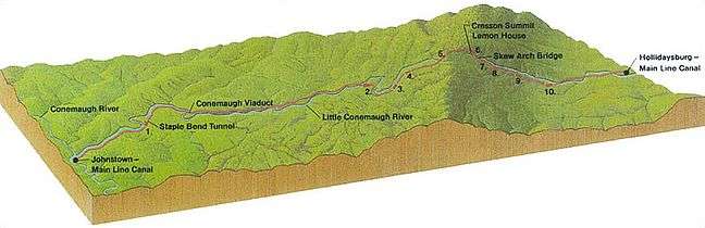
Historically, one of the southern gaps, the Blair Gap was used for the upper sections of the Allegheny Portage Railroad, which as was authorized by the enabling acts in 1824 of Pennsylvania's Main Line of Public Works as part of the Pennsylvania Canal System which originally envisioned linking Pittsburgh to Philadelphia by canals. In the early 1900s, US Route 22 followed along side the watercourse through that particular gap. Just to the north, the famous Horseshoe Curve built by the Pennsylvania Railroad crosses or utilizes no less than four gaps of the Alleghenies as it wends its way to cross the drainage divide in its two climb-saving tunnels built through the summit to its marshaling yard in Gallitzin, PA.
Until around the 1920s, after new founded auto clubs gathered enough numbers to political clout to push for initiatives creating roads between towns, off the railroads the primary means of travel town to town was on foot or where hauling was needed, using wagons. There were only five ways through the Appalachians east to west: Around the bottom (plains or Piedmont area) in Georgia, the Cumberland Gap,[lower-alpha 3] the Cumberland Narrows,[lower-alpha 4] the gaps of the Allegheny Front,[lower-alpha 5] and up the Hudson River then around the north end of the Catskills and across upstate New York, the so called level water route to the Great Lakes. All other transits involve difficult climbs a man on foot can only make with great difficulty, and which animal drawn transport could not. Geographically and geologically, without the large projects and engineering capabilities of the 20th century, there were exactly three internal regions where it was possible to get animal powered vehicles from the east side to the west side of the Appalachian Mountains, making five routes overall counting traveling around the plains at either end of the western chain.
Elsewhere, the mountains were pierced by various local and state roads during the public works projects of the Great Depression years sponsored by the Works Progress Administration in the 1930s when and where large edifices were not needed; and where major engineering works were needed, these roads taken for granted so much today could not be constructed until capital and the 20th century technologies such as bulldozers, steam shovels, and steel bridges became available and politically necessary. These new roads, now all less than 100 years old so young in terms of geography, would greatly diminish awareness of how important the three bottleneck passes were through the mountains, or the influence of the routes around the two ends.
List of Gaps
The official USGS Geographic Name Identification System (GNIS) assigns the following names and the associated data for the various gaps of the Allegheny Ridge.
Blair Gap
Blair Gap, one of the gaps of the Allegheny is a water gap along the eastern face atop the Allegheny Ridge or Allegheny Front escarpment. Like other 'gaps of the Allegheny' the slopes of Blair Gap were amenable to foot travel, pack mules, and possibly wagons allowing Amerindians, and then, after about 1778-1780 settlers, to travel west into the relatively depopulated Ohio Country decades before the railroads were born and tied the country together with steel. Historically, the gap was used for the upper sections of the Allegheny Portage Railroad, which as was authorized by the enabling acts in 1824 of Pennsylvania's Main Line of Public Works as part of the Pennsylvania Canal System which originally envisioned linking Pittsburgh to Philadelphia by canals.
Kittanning Gap
The USGS official Kittanning Gap contains at best a small spring that is most active as a spring freshet. Examination of the topology however shows that notch leads to a series of climbable traverses and was quite possibly the route of choice for wagons climbing toward the gently rolling oddly folded hill country summit and divide near the source of Clearfield Creek, Pennsylvania. Having reached that height, the travelers had also climbed the escarpment, albeit by a longer more circuitous climb than by directly assaulting one of the steeper but narrower gaps cut by more vigorous streams.
The gap of Kittanning Run
Next upstream along Glen White Run and above Kittanning Gap is the gap carved by Kittanning Run, a creek which originates in a woodland above a field in a bedroom community in Gallitzin Township, Pennsylvania at an elevation a bit over 2,400 feet (730 m)...
Notes
- ↑ Writing in 'Historic Indian Paths of Pennsylvania' in 1952, a preliminary study report to the Pennsylvania and Museum Commission on the state of his research under the direction of the State Historian S.K. Stevens, author Paul A. W. Wallace
- ↑ Smaller streams cutting the Ridge and Valley Appalachians in Pennsylvania are east to west, the Lehigh River, the Little Schuylkill River, the Schuylkill River, the Juniata River and Clearfield Creek.
- ↑ The Cumberland Gap is the route explore famously by Daniel Boone from upstate North Carolina and far southern Virginia west through the gap into Kentucky and Tennessee's eastern landforms.
- ↑ The Cumberland Narrows is the center route of the three interior crossings. The routes rise from the Potomac River and Chesapeake Bay basin west of Cumberland, Maryland and is the gap exploited by Chief Nemacolin's Path, the Braddock Expedition, the National Pike, the Baltimore and Ohio Railroad, the Western Maryland Railway, and US Route 40 to reach the Allegheny Plateau connecting the major eastern coastal cities of Baltimore and Washington, D.C. to reach the Monongahela River in Fayette County, Pennsylvania or Wheeling, West Virginia on the Ohio River via the historic gateway towns of Uniontown and Brownsville, PA. Alternatively, exploiting the relative flats after the main climb in Somerset County, Pennsylvania the Cumberland Narrows enables roads to jog north and descend from the plateau uplands following the watershed of the Youghiogheny River and descend to Pittsburgh. But the Youghiogheny descent also allows an easy cross-route cutting across the divide to the Allegheny valley and roads traveling upriver along the west side of the Alleghenies, connecting Maryland indirectly to the plains of the eastern Great Lakes near Erie, Pennsylvania and western New York State in the Buffalo and Rochester.
- ↑ The terms gaps of the Allegheny and the Allegheny Front are from two different disciplines. The former used by historians describing the local measures taken during the French and Indian War and Amerindian territories before the United States Constitution.