Ganges
| The Ganga River (Ganga) | |
| River | |
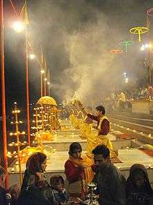
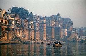 The Ganges in Varanasi | |
| Countries | |
|---|---|
| States | Uttarakhand, Uttar Pradesh, Bihar, Jharkhand, West Bengal |
| Tributaries | |
| - left | Ramganga, Gomti, Ghaghara, Gandaki, Bagmati, Koshi, Mahananda |
| - right | Yamuna, Tamsa, Son, Punpun |
| Cities | Rishikesh, Haridwar, Farrukhabad, Kanpur, Jajmau, Allahabad, Mirzapur, Varanasi, Ghazipur, Buxar, Ballia, Patna, Hajipur, Munger, Bhagalpur, Raebareli |
| Source | Gangotri Glacier, Satopanth Glacier, Khatling Glacier, and waters from melted snow from such peaks as Nanda Devi, Trisul, Kedarnath, Nanda Kot, and Kamet. |
| - location | Uttarakhand, India |
| - elevation | 3,892 m (12,769 ft) |
| - coordinates | 30°59′N 78°55′E / 30.983°N 78.917°E |
| Mouth | Ganges Delta |
| - location | Bay of Bengal, Bangladesh & Rindia |
| - elevation | 0 m (0 ft) |
| - coordinates | 22°05′N 90°50′E / 22.083°N 90.833°ECoordinates: 22°05′N 90°50′E / 22.083°N 90.833°E |
| Length | 2,525 km (1,569 mi) [1] |
| Basin | 1,080,000 km2 (416,990 sq mi) [2] |
| Discharge | for Farakka Barrage |
| - average | 16,648 m3/s (587,919 cu ft/s) [3] |
| - max | 70,000 m3/s (2,472,027 cu ft/s) |
| - min | 2,000 m3/s (70,629 cu ft/s) |
| Discharge elsewhere (average) | |
| - Bay of Bengal | 38,129 m3/s (1,346,513 cu ft/s) [3] |
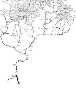
 Map of the combined drainage basins of the Ganges (orange), Brahmaputra (violet), and Meghna (green).
| |

The Ganges (/ˈɡændʒiːz/ GAN-jeez), also Ganga (Hindustani: [ˈɡəŋɡaː]) is a trans-boundary river of Asia which flows through the nations of India and Bangladesh. The 2,525 km (1,569 mi) river rises in the western Himalayas in the Indian state of Uttarakhand, and flows south and east through the Gangetic Plain of North India into Bangladesh, where it empties into the Bay of Bengal. It is the third largest river in the world by discharge.
The Ganges is the most sacred river to Hindus.[4] It is also a lifeline to millions of Indians who live along its course and depend on it for their daily needs.[5] It is worshipped as the goddess Ganga in Hinduism.[6] It has also been important historically, with many former provincial or imperial capitals (such as Pataliputra,[7] Kannauj,[7] Kara, Kashi, Patna, Hajipur, Munger, Bhagalpur, Murshidabad, Baharampur, Kampilya, and Kolkata) located on its banks.
The Ganges was ranked as the fifth most polluted river of the world in 2007. Pollution threatens not only humans, but also more than 140 fish species, 90 amphibian species and the endangered Ganges river dolphin. The Ganga Action Plan, an environmental initiative to clean up the river, has been a major failure thus far,[lower-alpha 1][lower-alpha 2][8] due to corruption, lack of technical expertise,[lower-alpha 3] poor environmental planning,[lower-alpha 4] and lack of support from religious authorities.[lower-alpha 5]
The name "Ganges", ending in "-es", came to English via Latin from Ancient Greek sources, particularly from accounts of Alexander the Great's wars, which entered India.
Course


The Ganges begins at the confluence of the Bhagirathi and Alaknanda rivers. The Bhagirathi is considered to be the source in Hindu culture and mythology, although the Alaknanda is longer.[9][10] The headwaters of the Alakananda are formed by snowmelt from such peaks as Nanda Devi, Trisul, and Kamet. The Bhagirathi rises at the foot of Gangotri Glacier, at Gomukh, at an elevation of 3,892 m (12,769 ft), being mythologically referred to as, residing in the matted locks of Shiva, symbolically Tapovan, being a meadow of ethereal beauty at the feet of Mount Shivling, just 5 km (3.1 mi) away.[11][12]
Although many small streams comprise the headwaters of the Ganges, the six longest and their five confluences are considered sacred. The six headstreams are the Alaknanda, Dhauliganga, Nandakini, Pindar, Mandakini, and Bhagirathi rivers. The five confluences, known as the Panch Prayag, are all along the Alaknanda. They are, in downstream order, Vishnuprayag, where the Dhauliganga joins the Alaknanda; Nandprayag, where the Nandakini joins; Karnaprayag, where the Pindar joins, Rudraprayag, where the Mandakini joins; and finally, Devprayag, where the Bhagirathi joins the Alaknanda to form the Ganges River proper.[9]
After flowing 250 km (160 mi)[12] through its narrow Himalayan valley, the Ganges emerges from the mountains at Rishikesh, then debouches onto the Gangetic Plain at the pilgrimage town of Haridwar.[9] At Haridwar, a dam diverts some of its waters into the Ganges Canal, which irrigates the Doab region of Uttar Pradesh, whereas the river, whose course has been roughly southwest until this point, now begins to flow southeast through the plains of northern India.
The Ganges follows an 800 km (500 mi) arching course passing through the cities of Kannauj, Farukhabad, and Kanpur. Along the way it is joined by the Ramganga, which contributes an average annual flow of about 500 m3/s (18,000 cu ft/s).[13] The Ganges joins the Yamuna at the Triveni Sangam at Allahabad, a holy confluence in Hinduism. At their confluence the Yamuna is larger than the Ganges, contributing about 2,950 m3/s (104,000 cu ft/s),[13] or about 58.5% of the combined flow.[14]
Now flowing east, the river meets the Tamsa River (also called Tons), which flows north from the Kaimur Range and contributes an average flow of about 190 m3/s (6,700 cu ft/s). After the Tamsa the Gomti River joins, flowing south from the Himalayas. The Gomti contributes an average annual flow of about 234 m3/s (8,300 cu ft/s). Then the Ghaghara River (Karnali River), also flowing south from the Himalayas of Nepal, joins. The Ghaghara (Karnali), with its average annual flow of about 2,990 m3/s (106,000 cu ft/s), is the largest tributary of the Ganges. After the Ghaghara (Karnali) confluence the Ganges is joined from the south by the Son River, contributing about 1,000 m3/s (35,000 cu ft/s). The Gandaki River, then the Kosi River, join from the north flowing from Nepal, contributing about 1,654 m3/s (58,400 cu ft/s) and 2,166 m3/s (76,500 cu ft/s), respectively. The Kosi is the third largest tributary of the Ganges, after the Ghaghara (Karnali) and Yamuna.[13]
Along the way between Allahabad and Malda, West Bengal, the Ganges passes the towns of Chunar, Mirzapur, Varanasi, Ghazipur, Patna, Bhagalpur, Ballia, Buxar, Simaria, Sultanganj, and Saidpur. At Bhagalpur, the river begins to flow south-southeast and at Pakur, it begins its attrition with the branching away of its first distributary, the Bhāgirathi-Hooghly, which goes on to become the Hooghly River. Just before the border with Bangladesh the Farakka Barrage controls the flow of the Ganges, diverting some of the water into a feeder canal linked to the Hooghly for the purpose of keeping it relatively silt-free. The Hooghly River is formed by the confluence of the Bhagirathi River and Jalangi River at Nabadwip, and Hooghly has a number of tributaries of its own. The largest is the Damodar River, which is 541 km (336 mi) long, with a drainage basin of 25,820 km2 (9,970 sq mi).[15] The Hooghly River empties into the Bay of Bengal near Sagar Island.[16] Between Malda and the Bay of Bengal, the Hooghly river passes the towns and cities of Murshidabad, Nabadwip, Kolkata and Howrah.
After entering Bangladesh, the main branch of the Ganges is known as the Padma. The Padma is joined by the Jamuna River, the largest distributary of the Brahmaputra. Further downstream, the Padma joins the Meghna River, the second largest distributary of the Brahmaputra, and takes on the Meghna's name as it enters the Meghna Estuary, which empties into the Bay of Bengal.
The Ganges Delta, formed mainly by the large, sediment-laden flows of the Ganges and Brahmaputra rivers, is the world's largest delta, at about 59,000 km2 (23,000 sq mi).[17] It stretches 322 km (200 mi) along the Bay of Bengal.[18]
Only the Amazon and Congo rivers have a greater average discharge than the combined flow of the Ganges, the Brahmaputra, and the Surma-Meghna river system.[18] In full flood only the Amazon is larger.[19]
Geology
The Indian subcontinent lies atop the Indian tectonic plate, a minor plate within the Indo-Australian Plate.[20] Its defining geological processes commenced seventy-five million years ago, when, as a part of the southern supercontinent Gondwana, it began a northeastwards drift—lasting fifty million years—across the then unformed Indian Ocean.[20] The subcontinent's subsequent collision with the Eurasian Plate and subduction under it, gave rise to the Himalayas, the planet's highest mountain ranges.[20] In the former seabed immediately south of the emerging Himalayas, plate movement created a vast trough, which, having gradually been filled with sediment borne by the Indus and its tributaries and the Ganges and its tributaries,[21] now forms the Indo-Gangetic Plain.[22]
The Indo-Gangetic Plain is geologically known as a foredeep or foreland basin.[23]
Hydrology

The hydrology of the Ganges River is very complicated, especially in the Ganges Delta region. One result is different ways to determine the river's length, its discharge, and the size of its drainage basin.

.JPG)
The name Ganges is used for the river between the confluence of the Bhagirathi and Alaknanda rivers, in the Himalayas, and the India-Bangladesh border, near the Farakka Barrage and the first bifurcation of the river. The length of the Ganges is frequently said to be slightly over 2,500 km (1,600 mi) long, about 2,505 km (1,557 mi),[24] to 2,525 km (1,569 mi),[25][14] or perhaps 2,550 km (1,580 mi).[26] In these cases the river's source is usually assumed to be the source of the Bhagirathi River, Gangotri Glacier at Gomukh, and its mouth being the mouth of the Meghna River on the Bay of Bengal.[25][14][24][26] Sometimes the source of the Ganges is considered to be at Haridwar, where its Himalayan headwater streams debouch onto the Gangetic Plain.[27]
In some cases, the length of the Ganges is given for its Hooghly River distributary, which is longer than its main outlet via the Meghna River, resulting in a total length of about 2,620 km (1,630 mi), from the source of the Bhagirathi,[17] or 2,135 km (1,327 mi), from Haridwar to the Hooghly's mouth.[28] In other cases the length is said to be about 2,240 km (1,390 mi), from the source of the Bhagirathi to the Bangladesh border, where its name changes to Padma.[29]
For similar reasons, sources differ over the size of the river's drainage basin. The basin covers parts of four countries, India, Nepal, China, and Bangladesh; eleven Indian states, Himachal Pradesh, Uttarakhand, Uttar Pradesh, Madhya Pradesh, Chhattisgarh, Bihar, Jharkhand, Punjab, Haryana, Rajasthan, West Bengal, and the Union Territory of Delhi.[30] The Ganges basin, including the delta but not the Brahmaputra or Meghna basins, is about 1,080,000 km2 (420,000 sq mi), of which 861,000 km2 (332,000 sq mi) are in India (about 80%), 140,000 km2 (54,000 sq mi) in Nepal (13%), 46,000 km2 (18,000 sq mi) in Bangladesh (4%), and 33,000 km2 (13,000 sq mi) in China (3%).[31] Sometimes the Ganges and Brahmaputra–Meghna drainage basins are combined for a total of about 1,600,000 km2 (620,000 sq mi),[19] or 1,621,000 km2 (626,000 sq mi).[18] The combined Ganges-Brahmaputra-Meghna basin (abbreviated GBM or GMB) drainage basin is spread across Bangladesh, Bhutan, India, Nepal, and China.[32]
The Ganges basin ranges from the Himalaya and the Transhimalaya in the north, to the northern slopes of the Vindhya range in the south, from the eastern slopes of the Aravalli in the west to the Chota Nagpur plateau and the Sunderbans delta in the east. A significant portion of the discharge from the Ganges comes from the Himalayan mountain system. Within the Himalaya, the Ganges basin spreads almost 1,200 km from the Yamuna-Satluj divide along the Simla ridge forming the boundary with the Indus basin in the west to the Singalila Ridge along the Nepal-Sikkim border forming the boundary with the Brahmaputra basin in the east. This section of the Himalaya contains 9 of the 14 highest peaks in the world over 8,000m in height, including Mount Everest which is the high point of the Ganges basin.[33] The other peaks over 8,000m in the basin are Kangchenjunga,[34] Lhotse,[35] Makalu,[36] Cho Oyu,[37] Dhaulagiri,[38] Manaslu,[39] Annapurna[40] and Shishapangma.[41] The Himalayan portion of the basin includes the south-eastern portion of the state of Himachal Pradesh, the entire state of Uttarakhand, the entire country of Nepal and the extreme north-western portion of the state of West Bengal.
The discharge of the Ganges also differs by source. Frequently, discharge is described for the mouth of the Meghna River, thus combining the Ganges with the Brahmaputra and Meghna. This results in a total average annual discharge of about 38,000 m3/s (1,300,000 cu ft/s),[18] or 42,470 m3/s (1,500,000 cu ft/s).[17] In other cases the average annual discharges of the Ganges, Brahmaputra, and Meghna are given separately, at about 16,650 m3/s (588,000 cu ft/s) for the Ganges, about 19,820 m3/s (700,000 cu ft/s) for the Brahmaputra, and about 5,100 m3/s (180,000 cu ft/s) for the Meghna.[25]
.JPG)
The maximum peak discharge of the Ganges, as recorded at Hardinge Bridge in Bangladesh, exceeded 70,000 m3/s (2,500,000 cu ft/s).[42] The minimum recorded at the same place was about 180 m3/s (6,400 cu ft/s), in 1997.[43]
The hydrologic cycle in the Ganges basin is governed by the Southwest Monsoon. About 84% of the total rainfall occurs in the monsoon from June to September. Consequently, streamflow in the Ganges is highly seasonal. The average dry season to monsoon discharge ratio is about 1:6, as measured at Hardinge Bridge. This strong seasonal variation underlies many problems of land and water resource development in the region.[29] The seasonality of flow is so acute it can cause both drought and floods. Bangladesh, in particular, frequently experiences drought during the dry season and regularly suffers extreme floods during the monsoon.[43]
In the Ganges Delta many large rivers come together, both merging and bifurcating in a complicated network of channels. The two largest rivers, the Ganges and Brahmaputra, both split into distributary channels, the largest of which merge with other large rivers before themselves joining. This current channel pattern was not always the case. Over time the rivers in Ganges Delta have changed course, sometimes altering the network of channels in significant ways.
Before the late 12th century the Bhagirathi-Hooghly distributary was the main channel of the Ganges and the Padma was only a minor spill-channel. The main flow of the river reached the sea not via the modern Hooghly River but rather by the Adi Ganga. Between the 12th and 16th centuries the Bhagirathi-Hooghly and Padma channels were more or less equally significant. After the 16th century the Padma grew to become the main channel of the Ganges.[16] It is thought that the Bhagirathi-Hooghly became increasingly choked with silt, causing the main flow of the Ganges to shift to the southeast and the Padma River. By the end of the 18th century the Padma had become the main distributary of the Ganges.[17] One result of this shift to the Padma was that the Ganges joined the Meghna and Brahmaputra rivers before emptying into the Bay of Bengal, together instead of separately. The present confluence of the Ganges and Meghna formed about 150 years ago.[44]
Also near the end of the 18th century, the course of the lower Brahmaputra changed dramatically, altering its relationship with the Ganges. In 1787 there was a great flood on the Teesta River, which at the time was a tributary of the Ganges-Padma River. The flood of 1787 caused the Teesta to undergo a sudden change course (an avulsion), shifting east to join the Brahmaputra and causing the Brahmaputra to shift its course south, cutting a new channel. This new main channel of the Brahmaputra is called the Jamuna River. It flows south to join the Ganges-Padma. Since ancient times the main flow of the Brahmaputra was more easterly, passing by the city of Mymensingh and joining the Meghna River. Today this channel is a small distributary but retains the name Brahmaputra, sometimes Old Brahmaputra.[45] The site of the old Brahmaputra-Meghna confluence, in the locality of Langalbandh, is still considered sacred by Hindus. Near the confluence is a major early historic site called Wari-Bateshwar.[16]
History

The Late Harappan period, about 1900–1300 BCE, saw the spread of Harappan settlement eastward from the Indus River basin to the Ganges-Yamuna doab, although none crossed the Ganges to settle its eastern bank. The disintegration of the Harappan civilisation, in the early 2nd millennium BC, marks the point when the centre of Indian civilisation shifted from the Indus basin to the Ganges basin.[46] There may be links between the Late Harappan settlement of the Ganges basin and the archaeological culture known as "Cemetery H", the Indo-Aryan people, and the Vedic period.
This river is the longest in India.[47] During the early Vedic Age of the Rigveda, the Indus and the Sarasvati River were the major sacred rivers, not the Ganges. But the later three Vedas gave much more importance to the Ganges.[lower-alpha 6] The Gangetic Plain became the centre of successive powerful states, from the Maurya Empire to the Mughal Empire.[9][48]
The first European traveller to mention the Ganges was Megasthenes (ca. 350–290 BCE). He did so several times in his work Indica: "India, again, possesses many rivers both large and navigable, which, having their sources in the mountains which stretch along the northern frontier, traverse the level country, and not a few of these, after uniting with each other, fall into the river called the Ganges. Now this river, which at its source is 30 stadia broad, flows from north to south, and empties its waters into the ocean forming the eastern boundary of the Gangaridai, a nation which possesses a vast force of the largest-sized elephants." (Diodorus II.37)[49] In the rainy season of 1809, the lower channel of the Bhagirathi, leading to Kolkata, had been entirely shut; but in the following year it opened again, and was nearly of the same size with the upper channel; both however suffered a considerable diminution, owing probably to the new communication opened below the Jalanggi on the upper channel.
In 1951 a water sharing dispute arose between India and Bangladesh (then East Pakistan), after India declared its intention to build the Farakka Barrage. The original purpose of the barrage, which was completed in 1975, was to divert up to 1,100 m3/s (39,000 cu ft/s) of water from the Ganges to the Bhagirathi-Hooghly distributary in order to restore navigability at the Port of Kolkata. It was assumed that during the worst dry season the Ganges flow would be around 1,400 to 1,600 m3/s (49,000 to 57,000 cu ft/s), thus leaving 280 to 420 m3/s (9,900 to 14,800 cu ft/s) for the then East Pakistan.[50] East Pakistan objected and a protracted dispute ensued. In 1996 a 30-year treaty was signed with Bangladesh. The terms of the agreement are complicated, but in essence they state that if the Ganges flow at Farakka was less than 2,000 m3/s (71,000 cu ft/s) then India and Bangladesh would each receive 50% of the water, with each receiving at least 1,000 m3/s (35,000 cu ft/s) for alternating ten-day periods. However, within a year the flow at Farakka fell to levels far below the historic average, making it impossible to implement the guaranteed sharing of water. In March 1997, flow of the Ganges in Bangladesh dropped to its lowest ever, 180 m3/s (6,400 cu ft/s). Dry season flows returned to normal levels in the years following, but efforts were made to address the problem. One plan is for another barrage to be built in Bangladesh at Pangsha, west of Dhaka. This barrage would help Bangladesh better utilise its share of the waters of the Ganges.[lower-alpha 7]
Religious and cultural significance
Embodiment of sacredness
The Ganga is a sacred river to Hindus along every fragment of its length. All along its course, Hindus bathe in its waters,[51] paying homage to their ancestors and to their gods by cupping the water in their hands, lifting it and letting it fall back into the river; they offer flowers and rose petals and float shallow clay dishes filled with oil and lit with wicks (diyas).[51] On the journey back home from the Ganga, they carry small quantities of river water with them for use in rituals (ganga jal, literally water of the Ganga).[52] When a loved one dies, Hindus bring the ashes of the deceased person to the Ganga River.[52]
The Ganga is the embodiment of all sacred waters in Hindu mythology.[53] Local rivers are said to be like the Ganga, and are sometimes called the local Ganga.[53] The Kaveri river of Karnataka and Tamil Nadu in Southern India is called the Ganga of the South; the Godavari, is the Ganga that was led by the sage Gautama to flow through Central India.[53] The Ganga is invoked whenever water is used in Hindu ritual, and is therefore present in all sacred waters.[53] In spite of this, nothing is more stirring for a Hindu than a dip in the actual river, which is thought to remit sins, especially at one of the famous tirthas such as Gangotri, Haridwar, Prayag, or Varanasi.[53] The symbolic and religious importance of the Ganga is one of the few things that Hindu India, even its sceptics, are agreed upon.[54] Jawaharlal Nehru, a religious iconoclast himself, asked for a handful of his ashes to be thrown into the Ganga.[54] "The Ganga," he wrote in his will, "is the river of India, beloved of her people, round which are intertwined her racial memories, her hopes and fears, her songs of triumph, her victories and her defeats. She has been a symbol of India's age-long culture and civilization, ever-changing, ever-flowing, and yet ever the same Ganga."[54]
Avatarana or descent of the Ganga

In late May or early June every year, Hindus celebrate the avatarana or descent of the Ganga from heaven to earth.[55] The day of the celebration, Ganga Dashahara, the dashami (tenth day) of the waxing moon of the Hindu calendar month Jyestha, brings throngs of bathers to the banks of the river.[55] A soak in the Ganga on this day is said to rid the bather of ten sins (dasha = Sanskrit "ten"; hara = to destroy) or alternatively, ten lifetimes of sins.[55] Those who cannot journey to the river, however, can achieve the same results by bathing in any nearby body of water, which, for the true believer, in the Hindu tradition, takes on all the attributes of the Ganga.[55]
The avatarana is an old theme in Hinduism with a number of different versions of the story.[55] In the Vedic version, Indra, the Lord of Svarga (Heaven) slays the celestial serpent, Vritra, releasing the celestial liquid, the soma, or the nectar of the gods which then plunges to the earth and waters it with sustenance.[55]
In the Vaishnava version of the myth, Indra has been replaced by his former helper Vishnu.[55] The heavenly waters are now a river called Vishnupadi (padi: Skt. "from the foot of").[55] As he completes his celebrated three strides—of earth, sky, and heaven—Vishnu as Vamana stubs his toe on the vault of heaven, punches open a hole, and releases the Vishnupadi, which until now had been circling around the cosmic egg within.[56] Flowing out of the vault, she plummets down to Indra's heaven, where she is received by Dhruva, the once steadfast worshipper of Vishnu, now fixed in the sky as the polestar.[56] Next, she streams across the sky forming the Milky Way and arrives on the moon.[56] She then flows down earthwards to Brahma's realm, a divine lotus atop Mount Meru, whose petals form the earthly continents.[56] There, the divine waters break up, with one stream, the Alaknanda, flowing down one petal into Bharatvarsha (India) as the Ganga.[56]
It is Shiva, however, among the major deities of the Hindu pantheon, who appears in the most widely known version of the avatarana story.[57] Told and retold in the Ramayana, the Mahabharata and several Puranas, the story begins with a sage, Kapila, whose intense meditation has been disturbed by the sixty thousand sons of King Sagara. Livid at being disturbed, Kapila sears them with his angry gaze, reduces them to ashes, and dispatches them to the netherworld. Only the waters of the Ganga, then in heaven, can bring the dead sons their salvation. A descendant of these sons, King Bhagiratha, anxious to restore his ancestors, undertakes rigorous penance and is eventually granted the prize of Ganga's descent from heaven. However, since her turbulent force would also shatter the earth, Bhagiratha persuades Shiva in his abode on Mount Kailash to receive Ganga in the coils of his tangled hair and break her fall. Ganga descends, is tamed in Shiva's locks, and arrives in the Himalayas. She is then led by the waiting Bhagiratha down into the plains at Haridwar, across the plains first to the confluence with the Yamuna at Prayag and then to Varanasi, and eventually to Ganga Sagar, where she meets the ocean, sinks to the netherworld, and saves the sons of Sagara.[57] In honour of Bhagirath's pivotal role in the avatarana, the source stream of the Ganga in the Himalayas is named Bhagirathi, (Sanskrit, "of Bhagiratha").[57]
Redemption of the dead
Since Ganga had descended from heaven to Earth, she is also the vehicle of ascent, from Earth to heaven.[58] As the Triloka-patha-gamini, (Skt. triloka= "three worlds", patha = "road", gamini = "one who travels") of the Hindu tradition, she flows in heaven, earth, and the netherworld, and, consequently, is a "tirtha," or crossing point of all beings, the living as well as the dead.[58] It is for this reason that the story of the avatarana is told at Shraaddha ceremonies for the deceased in Hinduism, and Ganga water is used in Vedic rituals after death.[58] Among all hymns devoted to the Ganga, there are none more popular than the ones expressing the worshiper's wish to breathe his last surrounded by her waters.[58] The Gangashtakam expresses this longing fervently:[58]
O Mother! …Necklace adorning the worlds!
Banner rising to heaven!
I ask that I may leave of this body on your banks,
Drinking your water, rolling in your waves,
Remembering your name, bestowing my gaze upon you.[59]
No place along her banks is more longed for at the moment of death by Hindus than Varanasi, the Great Cremation Ground, or Mahashmashana.[58] Those who are lucky enough to die in Varanasi, are cremated on the banks of the Ganga, and are granted instant salvation.[60] If the death has occurred elsewhere, salvation can be achieved by immersing the ashes in the Ganga.[60] If the ashes have been immersed in another body of water, a relative can still gain salvation for the deceased by journeying to the Ganga, if possible during the lunar "fortnight of the ancestors" in the Hindu calendar month of Ashwin (September or October), and performing the Shraaddha rites.[60]
Hindus also perform pinda pradana, a rite for the dead, in which balls of rice and sesame seed are offered to the Ganga while the names of the deceased relatives are recited.[61] Every sesame seed in every ball thus offered, according to one story, assures a thousand years of heavenly salvation for the each relative.[61] Indeed, the Ganga is so important in the rituals after death that the Mahabharata, in one of its popular ślokas, says, "If only (one) bone of a (deceased) person should touch the water of the Ganga, that person shall dwell honoured in heaven."[62] As if to illustrate this truism, the Kashi Khanda (Varanasi Chapter) of the Skanda Purana recounts the remarkable story of Vahika, a profligate and unrepentant sinner, who is killed by a tiger in the forest. His soul arrives before Yama, the Lord of Death, to be judged for the hereafter. Having no compensating virtue, Vahika's soul is at once dispatched to hell. While this is happening, his body on earth, however, is being picked at by vultures, one of whom flies away with a foot bone. Another bird comes after the vulture, and in fighting him off, the vulture accidentally drops the bone into the Ganga below. Blessed by this happenstance, Vahika, on his way to hell, is rescued by a celestial chariot which takes him instead to heaven.[63]
The purifying Ganga
Hindus consider the waters of the Ganga to be both pure and purifying.[64] Nothing reclaims order from disorder more than the waters of the Ganga.[65] Moving water, as in a river, is considered purifying in Hindu culture because it is thought to both absorb impurities and take them away.[65] The swiftly moving Ganga, especially in its upper reaches, where a bather has to grasp an anchored chain in order to not be carried away, is considered especially purifying.[65] What the Ganga removes, however, is not necessarily physical dirt, but symbolic dirt; it wipes away the sins of the bather, not just of the present, but of a lifetime.[65]
A popular paean to the Ganga is the Ganga Lahiri composed by a seventeenth century poet Jagannatha who, legend has it, was turned out of his Hindu Brahmin caste for carrying on an affair with a Muslim woman. Having attempted futilely to be rehabilitated within the Hindu fold, the poet finally appeals to Ganga, the hope of the hopeless, and the comforter of last resort. Along with his beloved, Jagannatha sits at the top of the flight of steps leading to the water at the famous Panchganga Ghat in Varanasi. As he recites each verse of the poem, the water of the Ganga rises up one step, until in the end it envelops the lovers and carry them away.[65] "I come to you as a child to his mother," begins the Ganga Lahiri.[66]
I come as an orphan to you, moist with love.
I come without refuge to you, giver of sacred rest.
I come a fallen man to you, uplifter of all.
I come undone by disease to you, the perfect physician.
I come, my heart dry with thirst, to you, ocean of sweet wine.
Do with me whatever you will.[67]
Consort, shakti and mother

Ganga is a consort to all three major male deities of Hinduism.[68] As Brahma's partner she always travels with him in the form of water in his kamandalu (water-pot).[68] She is also Vishnu's consort.[68] She emanates from his foot as Vishnupadi in the avatarana story, and is also, with Sarasvati and Lakshmi, one of his wives.[68] In one popular story, envious of being outdone by each other, the wives begin to quarrel. While Lakshmi attempts to mediate the quarrel, Ganga and Sarasvati heap misfortune on each other. They curse each other to become rivers, and to carry within them, by washing, the sins of their human worshippers. Soon their husband, Vishnu, arrives and decides to calm the situation by separating the goddesses. He orders Sarasvati to become the wife of Brahma, Ganga to become the wife of Shiva, and Lakshmi, as the blameless conciliator, to remain as his own wife. Ganga and Sarasvati, however, are so distraught at this dispensation, and wail so loudly, that Vishnu is forced to take back his words. Consequently, in their lives as rivers they are still thought to be with him.[69]
It is Shiva's relationship with Ganga, that is the best-known in Ganga theology.[70] Her descent, the avatarana is not a one time event, but a continuously occurring one in which she is forever falling from heaven into his locks and being forever tamed.[70] Shiva is depicted in Hindu iconography as Gangadhara, the "Bearer of the Ganga," with Ganga, shown as spout of water, rising from his hair.[70] The Shiva-Ganga relationship is both perpetual and intimate.[70] Shiva is sometimes called Uma-Ganga-Patiswara ("Husband and Lord of Uma (Parvati) and Ganga"), and Ganga often arouses the jealousy of Shiva's better-known consort Parvati.[70]

Ganga is the shakti or the moving, restless, rolling energy in the form of which the otherwise recluse and unapproachable Shiva appears on earth.[68] As water, this moving energy can be felt, tasted, and absorbed.[68] The war-god Skanda addresses the sage Agastya in the Kashi Khand of the Skanda Purana in these words:[68]
One should not be amazed ... that this Ganga is really Power, for is she not the Supreme Shakti of the Eternal Shiva, taken in the form of water?
This Ganga, filled with the sweet wine of compassion, was sent out for the salvation of the world by Shiva, the Lord of the Lords.
Good people should not think this Triple-Pathed River to be like the thousand other earthly rivers, filled with water.[68]
The Ganga is also the mother, the Ganga Mata (mata="mother") of Hindu worship and culture, accepting all and forgiving all.[67] Unlike other goddesses, she has no destructive or fearsome aspect, destructive though she might be as a river in nature.[71] She is also a mother to other gods.[72] She accepts Shiva's incandescent seed from the fire-god Agni, which is too hot for this world, and cools it in her waters.[72] This union produces Skanda, or Kartikeya, the god of war.[72] In the Mahabharata, she is the wife of Shantanu, and the mother of heroic warrior-patriarch, Bhishma.[72] When Bhishma is mortally wounded in battle, Ganga comes out of the water in human form and weeps uncontrollably over his body.[72]
The Ganga is the distilled lifeblood of the Hindu tradition, of its divinities, holy books, and enlightenment.[68]As such, her worship does not require the usual rites of invocation (avahana) at the beginning and dismissal (visarjana) at the end, required in the worship of other gods.[68] Her divinity is immediate and everlasting.[68]
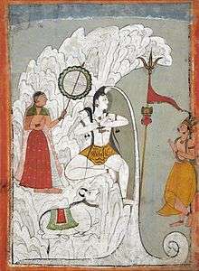
Ganga in classical Indian iconography
|

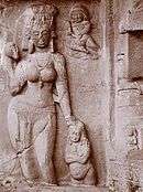
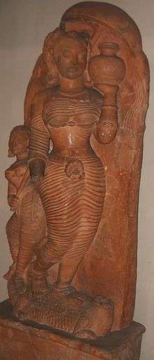

Early in ancient Indian culture, the river Ganga was associated with fecundity, its redeeming waters and its rich silt providing sustenance to all who lived along its banks.[73] A counterpoise to the dazzling heat of the Indian summer, the Ganga came to be imbued with magical qualities and to be revered in anthropomorphic form.[74] By the 5th century CE, an elaborate theology surrounded the Ganga, now a goddess in her own right, and a symbol for all rivers of India.[74][75] Hindu temples all over India had statues and reliefs of the goddess carved at their entrances, symbolically washing the sins of arriving worshippers and guarding the gods within.[75] As protector of the sanctum sanctorum, the goddess soon came to depicted with several characteristic accessories: the makara (a crocodile-like undersea monster, often shown with an elephant-like trunk), the kumbha (an overfull vase), various overhead parasol-like coverings, and a gradually increasing retinue of humans.[76]
Central to the goddess's visual identification is the makara, which is also her vahana, or mount. An ancient symbol in India, it pre-dates all appearances of the goddess Ganga in art.[76] The makara has a dual symbolism. On the one hand, it represents the life-affirming waters and plants of its environment; on the other, it represents fear, both fear of the unknown it elicits by lurking in those waters and real fear it instils by appearing in sight.[76] The earliest extant unambiguous pairing of the makara with Ganga is at Udayagiri Caves in Central India (circa 400 CE). Here, in Cave V, flanking the main figure of Vishnu shown in his boar incarnation, two river goddesses, Ganga and Yamuna appear atop their respective mounts, makara and kurma (a turtle or tortoise).[76]
The makara is often accompanied by a gana, a small boy or child, near its mouth, as, for example, shown in the Gupta period relief from Besnagar, Central India, in the left-most frame above.[77] The gana represents both posterity and development (udbhava).[77] The pairing of the fearsome, life-destroying makara with the youthful, life-affirming gana speaks to two aspects of the Ganga herself. Although she has provided sustenance to millions, she has also brought hardship, injury, and death by causing major floods along her banks.[78] The goddess Ganga is also accompanied by a dwarf attendant, who carries a cosmetic bag, and on whom she sometimes leans, as if for support.[75] (See, for example, frames 1, 2, and 4 above.)
The purna kumbha or full pot of water is the second most discernible element of the Ganga iconography.[79] Appearing first also in the relief in Udayagiri Caves (5th century), it gradually appeared more frequently as the theme of the goddess matured.[79] By the seventh century it had become an established feature, as seen, for example, the Dashavatara temple, Deogarh, Uttar Pradesh (seventh century), the Trimurti temple, Badoli, Chittorgarh, Rajasthan, and at the Lakshmaneshwar temple, Kharod, Bilaspur, Chhattisgarh,[79] (ninth or tenth century), and seen very clearly in frame 3 above and less clearly in the remaining frames. Worshipped even today, the full pot is emblematic of the formless Brahman, as well as of woman, of the womb, and of birth.[80] Furthermore, The river goddesses Ganga and Saraswati were both born from Brahma's pot, containing the celestial waters.[80]
In her earliest depictions at temple entrances, the goddess Ganga appeared standing beneath the overhanging branch of a tree, as seen as well in the Udayagiri caves.[81] However, soon the tree cover had evolved into a chatra or parasol held by an attendant, for example, in the seventh-century Dasavatara temple at Deogarh.[81] (The parasol can be clearly seen in frame 3 above; its stem can be seen in frame 4, but the rest has broken off.) The cover undergoes another transformation in the temple at Kharod, Bilaspur (ninth or tenth century), where the parasol is lotus-shaped,[81] and yet another at the Trimurti temple at Badoli where the parasol has been replaced entirely by a lotus.[81]
As the iconography evolved, sculptors in the central India especially were producing animated scenes of the goddess, replete with an entourage and suggestive of a queen en route to a river to bathe.[82] A relief similar to the depiction in frame 4 above, is described in Pal 1997, p. 43 as follows:
A typical relief of about the ninth century that once stood at the entrance of a temple, the river goddess Ganga is shown as a voluptuously endowed lady with a retinue. Following the iconographic prescription, she stands gracefully on her composite makara mount and holds a water pot. The dwarf attendant carries her cosmetic bag, and a ... female holds the stem of a giant lotus leaf that serves as her mistress's parasol. The fourth figure is a male guardian. Often in such reliefs the makara's tail is extended with great flourish into a scrolling design symbolizing both vegetation and water.[75]
Kumbh Mela
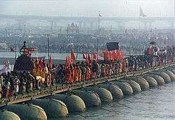
Kumbh Mela is a mass Hindu pilgrimage in which Hindus gather at the Ganga river. The normal Kumbh Mela is celebrated every 3 years, the Ardh (half) Kumbh is celebrated every six years at Haridwar and Prayag,[83] the Purna (complete) Kumbh takes place every twelve years[84] at four places (Prayag (Allahabad), Haridwar, Ujjain, and Nashik). The Maha (great) Kumbh Mela which comes after 12 'Purna Kumbh Melas', or 144 years, is held at Prayag (Allahabad).[84]
The major event of the festival is ritual bathing at the banks of the river. Other activities include religious discussions, devotional singing, mass feeding of holy men and women and the poor, and religious assemblies where doctrines are debated and standardised. Kumbh Mela is the most sacred of all the pilgrimages.[85][86] Thousands of holy men and women attend, and the auspiciousness of the festival is in part attributable to this. The sadhus are seen clad in saffron sheets with ashes and powder dabbed on their skin per the requirements of ancient traditions. Some, called naga sanyasis, may not wear any clothes.[87]
Irrigation
The Ganga and its tributaries, especially the Yamuna, have been used for irrigation since ancient times.[88] Dams and canals were common in gangetic plain by fourth century BCE.[89] The Ganga-Brahmaputra-Meghna basin has a huge hydroelectric potential, on the order of 200,000 to 250,000 megawatts, nearly half of which could be easily harnessed. As of 1999, India tapped about 12% of the hydroelectric potential of the Ganga and just 1% of the vast potential of the Brahmaputra.[90]
Canals

Megasthenes, a Greek ethnographer who visited India during third century BCE when Mauryans ruled India described the existence of canals in the gangetic plain. Kautilya (also known as Chanakya), an advisor to Chandragupta Maurya, the founder of Maurya Empire, included the destruction of dams and levees as a strategy during war.[89] Firuz Shah Tughlaq had many canals built, the longest of which, 240 km (150 mi), was built in 1356 on the Yamuna River. Now known as the Western Yamuna Canal, it has fallen into disrepair and been restored several times. The Mughal emperor Shah Jahan built an irrigation canal on the Yamuna River in the early 17th century. It fell into disuse until 1830, when it was reopened as the Eastern Yamuna Canal, under British control. The reopened canal became a model for the Upper Ganga Canal and all following canal projects.[88]

The first British canal in India—with no Indian antecedents—was the Ganga Canal built between 1842 and 1854.[91] Contemplated first by Col. John Russell Colvin in 1836, it did not at first elicit much enthusiasm from its eventual architect Sir Proby Thomas Cautley, who balked at idea of cutting a canal through extensive low-lying land in order to reach the drier upland destination. However, after the Agra famine of 1837–38, during which the East India Company's administration spent Rs. 2,300,000 on famine relief, the idea of a canal became more attractive to the Company's budget-conscious Court of Directors. In 1839, the Governor General of India, Lord Auckland, with the Court's assent, granted funds to Cautley for a full survey of the swath of land that underlay and fringed the projected course of the canal. The Court of Directors, moreover, considerably enlarged the scope of the projected canal, which, in consequence of the severity and geographical extent of the famine, they now deemed to be the entire Doab region.[92]
The enthusiasm, however, proved to be short lived. Auckland's successor as Governor General, Lord Ellenborough, appeared less receptive to large-scale public works, and for the duration of his tenure, withheld major funds for the project. Only in 1844, when a new Governor-General, Lord Hardinge, was appointed, did official enthusiasm and funds return to the Ganga canal project. Although the intervening impasse had seemingly affected Cautley's health and required him to return to Britain in 1845 for recuperation, his European sojourn gave him an opportunity to study contemporary hydraulic works in the United Kingdom and Italy. By the time of his return to India even more supportive men were at the helm, both in the North-Western Provinces, with James Thomason as Lt. Governor, and in British India with Lord Dalhousie as Governor-General. Canal construction, under Cautley's supervision, now went into full swing. A 350-mile long canal, with another 300 miles of branch lines, eventually stretched between the headworks in Hardwar, splitting into two branches below Aligarh, and its two confluences with the Yamuna (Jumna in map) mainstem in Etawah and the Ganga in Kanpur (Cawnpore in map). The Ganga Canal, which required a total capital outlay of £2.15 million, was officially opened in 1854 by Lord Dalhousie.[93] According to historian Ian Stone:
It was the largest canal ever attempted in the world, five times greater in its length than all the main irrigation lines of Lombardy and Egypt put together, and longer by a third than even the largest USA navigation canal, the Pennsylvania Canal.
Dams and barrages
A major barrage at Farakka was opened on 21 April 1975,[94] It is located close to the point where the main flow of the river enters Bangladesh, and the tributary Hooghly (also known as Bhagirathi) continues in West Bengal past Kolkata. This barrage, which feeds the Hooghly branch of the river by a 26-mile (42 km) long feeder canal, and its water flow management has been a long-lingering source of dispute with Bangladesh.[95] Indo-Bangladesh Ganga Water Treaty signed in December 1996 addressed some of the water sharing issues between India and Bangladesh.[94]
Tehri Dam was constructed on Bhagirathi River, tributary of the Ganga. It is located 1.5 km downstream of Ganesh Prayag, the place where Bhilangana meets Bhagirathi. Bhagirathi is called Ganga after Devprayag.[96] Construction of the dam in an earthquake prone area[97] was controversial.[98]
Bansagar Dam was built on the Son River, a tributary of the Ganga, for both irrigation and hydroelectric power generation.[99]
Economy

The Ganges Basin with its fertile soil is instrumental to the agricultural economies of India and Bangladesh. The Ganges and its tributaries provide a perennial source of irrigation to a large area. Chief crops cultivated in the area include rice, sugarcane, lentils, oil seeds, potatoes, and wheat. Along the banks of the river, the presence of swamps and lakes provide a rich growing area for crops such as legumes, chillies, mustard, sesame, sugarcane, and jute. There are also many fishing opportunities along the river, though it remains highly polluted. Also the major industrial towns of Unnao, Kanpur, situated on the banks of the river with the predominance of tanning industries add to the pollution.[100]
Tourism
Tourism is another related activity. Three towns holy to Hinduism – Haridwar, Prayag (Allahabad), and Varanasi – attract thousands of pilgrims to its waters to take a dip in the Ganges, which is believed to cleanse oneself of sins and help attain salvation. The rapids of the Ganges also are popular for river rafting, attracting adventure seekers in the summer months. Also, several cities such as Kanpur, Kolkata and Patna have developed riverfront walkways along the banks to attract tourists.[101][102][103][104]
Ecology and environment

Human development, mostly agriculture, has replaced nearly all of the original natural vegetation of the Ganga basin. More than 95% of the upper Gangetic Plain has been degraded or converted to agriculture or urban areas. Only one large block of relatively intact habitat remains, running along the Himalayan foothills and including Rajaji National Park, Jim Corbett National Park, and Dudhwa National Park.[105] As recently as the 16th and 17th centuries the upper Gangetic Plain harboured impressive populations of wild Asian elephants (Elephas maximus), tigers (Panthera tigris), Indian rhinoceros (Rhinoceros unicornis), gaurs (Bos gaurus), barasinghas (Rucervus duvaucelii), sloth bears (Melursus ursinus) and Indian lions.[105] In the 21st century there are few large wild animals, mostly deer, boars, wildcats, and small numbers of wolves, jackals, and foxes. Bengal tigers survive only in the Sundarbans area of the Ganga Delta. Crocodiles and barasingha are also found in the Sundarbans.[9] The Sundarbands freshwater swamp ecoregion, however, is nearly extinct.[106] Threatened mammals in the upper Gangetic Plain include the tiger, elephant, sloth bear, and chousingha (Tetracerus quadricornis).[105]

Fish are found in all the major rivers of the Ganga basin, and are a vital food source for many people. In the Bengal area common fish include featherbacks (Notopteridae family), barbs (Cyprinidae), walking catfish (Clarias batrachus), gouramis (Anabantidae), and milkfish (Chanos chanos).[9] The critically endangered Ganga shark (Glyphis gangeticus) is also found in the river and other places in Indian subcontinent.[107]
Many types of birds are found throughout the basin, such as myna, parrots, crows, kites, partridges, and fowls. Ducks and snipes migrate across the Himalayas during the winter, attracted in large numbers to wetland areas.[9] There are no endemic birds in the upper Gangetic Plain. The great Indian bustard (Ardeotis nigriceps) and lesser florican (Sypheotides indicus) are considered globally threatened.[105]
The natural forest of the upper Gangetic Plain has been so thoroughly eliminated it is difficult to assign a natural vegetation type with certainty. There are a few small patches of forest left, and they suggest that much of the upper plains may have supported a tropical moist deciduous forest with sal (Shorea robusta) as a climax species.[105]

The Ganga River itself supports the mugger crocodile (Crocodylus palustris) and the gharial (Gavialis gangeticus). The river's most famed fauna is the freshwater dolphin Platanista gangetica gangetica, the Ganga river dolphin,[105] recently declared India's national aquatic animal.[108]
A similar situation is found in the lower Gangetic Plain, which includes the lower Brahmaputra River. The lower plains contain more open forests, which tend to be dominated by Bombax ceiba in association with Albizzia procera, Duabanga grandiflora, and Sterculia vilosa. There are early seral forest communities that would eventually become dominated by the climax species sal (Shorea robusta), if forest succession was allowed to proceed. In most places forests fail to reach climax conditions due to human causes.[109] The forests of the lower Gangetic Plain, despite thousands of years of human settlement, remained largely intact until the early 20th century. Today only about 3% of the ecoregion is under natural forest and only one large block, south of Varanasi, remains. There are over forty protected areas in the ecoregion, but over half of these are less than 100 square kilometres (39 sq mi).[109] The fauna of the lower Gangetic Plain is similar to the upper plains, with the addition of a number of other species such as the smooth-coated otter (Lutrogale perspicillata) and the large Indian civet (Viverra zibetha).[109]
Ganga river dolphin

The Ganga river dolphin, which used to exist in large schools near to urban centres in both the Ganga and Brahmaputra rivers, is now seriously threatened by pollution and dam construction. Their numbers have now dwindled to a quarter of their numbers of fifteen years before, and they have become extinct in the Ganga's main tributaries.[lower-alpha 5] A recent survey by the World Wildlife Fund found only 3,000 left in the water catchment of both river systems.[110]
The Ganga river dolphin is one of only five freshwater dolphins in the world. The other four are the baiji (Lipotes vexillifer) of the Yangtze River in China, now likely extinct; the bhulan of the Indus River in Pakistan; the boto of the Amazon River in Brazil; and the Araguaian river dolphin (not considered a separate species until 2014[111]) of the Araguaia–Tocantins basin in Brazil. There are several marine dolphins whose ranges include some freshwater habitats, but these five are the only dolphins who live only in freshwater rivers and lakes.[109]
Effects of climate change
The Tibetan Plateau contains the world's third-largest store of ice. Qin Dahe, the former head of the China Meteorological Administration, said that the recent fast pace of melting and warmer temperatures will be good for agriculture and tourism in the short term; but issued a strong warning:
Temperatures are rising four times faster than elsewhere in China, and the Tibetan glaciers are retreating at a higher speed than in any other part of the world.... In the short term, this will cause lakes to expand and bring floods and mudflows... In the long run, the glaciers are vital lifelines for Asian rivers, including the Indus and the Ganges. Once they vanish, water supplies in those regions will be in peril.[112]
In 2007, the Intergovernmental Panel on Climate Change (IPCC), in its Fourth Report, stated that the Himalayan glaciers which feed the river, were at risk of melting by 2035.[113] The IPCC has now withdrawn that prediction, as the original source admitted that it was speculative and the cited source was not a peer reviewed finding.[lower-alpha 8] In its statement, the IPCC stands by its general findings relating to the Himalayan glaciers being at risk from global warming (with consequent risks to water flow into the Gangetic basin).
Pollution and environmental concerns

The Ganga suffers from extreme pollution levels, which affect the 400 million people who live close to the river.[114][115] Sewage from many cities along the river's course, industrial waste and religious offerings wrapped in non-degradable plastics add large amounts of pollutants to the river as it flows through densely populated areas.[8][116][117] The problem is exacerbated by the fact that many poorer people rely on the river on a daily basis for bathing, washing, and cooking.[116] The World Bank estimates that the health costs of water pollution in India equal three percent of India's GDP.[lower-alpha 9] It has also been suggested that eighty percent of all illnesses in India and one-third of deaths can be attributed to water-borne diseases.[lower-alpha 5]
Varanasi, a city of one million people that many pilgrims visit to take a "holy dip" in the Ganga, releases around 200 million litres of untreated human sewage into the river each day, leading to large concentrations of faecal coliform bacteria.[116] According to official standards, water safe for bathing should not contain more than 500 faecal coliforms per 100ml, yet upstream of Varanasi's ghats the river water already contains 120 times as much, 60,000 faecal coliform bacteria per 100 ml.[118][119]
After the cremation of the deceased at Varanasi's ghats the bones and ashes are thrown into the Ganga. However, in the past thousands of uncremated bodies were thrown into the Ganga during cholera epidemics, spreading the disease. Even today, holy men, pregnant women, people with leprosy/chicken pox, people who had been bitten by snakes, people who had committed suicide, the poor, and children under 5 are not cremated at the ghats but are floated free to decompose in the waters. In addition, those who cannot afford the large amount of wood needed to incinerate the entire body, leave behind a lot of half burned body parts.[120][121]
After passing through Varanasi, and receiving 32 streams of raw sewage from the city, the concentration of fecal coliforms in the river's waters rises from 60,000 to 1.5 million,[118][119] with observed peak values of 100 million per 100 ml.[116] Drinking and bathing in its waters therefore carries a high risk of infection.[116]
Between 1985 and 2000, Rs. 10 billion, around US$226 million, or less than 4 cents per person per year, were spent on the Ganga Action Plan,[8] an environmental initiative that was "the largest single attempt to clean up a polluted river anywhere in the world."[lower-alpha 4] The Ganga Action Plan has been described variously as a "failure",[122][lower-alpha 10][lower-alpha 11] a "major failure".[lower-alpha 1][lower-alpha 2][lower-alpha 9]
According to one study,[122]
The Ganga Action Plan, which was taken on priority and with much enthusiasm, was delayed for two years. The expenditure was almost doubled. But the result was not very appreciable. Much expenditure was done over the political propaganda. The concerning governments and the related agencies were not very prompt to make it a success. The public of the areas was not taken into consideration. The releasing of urban and industrial wastes in the river was not controlled fully. The flowing of dirty water through drains and sewers were not adequately diverted. The continuing customs of burning dead bodies, throwing carcasses, washing of dirty clothes by washermen, and immersion of idols and cattle wallowing were not checked. Very little provision of public latrines was made and the open defecation of lakhs of people continued along the riverside. All these made the Action Plan a failure.
The failure of the Ganga Action Plan, has also been variously attributed to "environmental planning without proper understanding of the human–environment interactions,"[lower-alpha 4] Indian "traditions and beliefs,"[lower-alpha 12] "corruption and a lack of technical knowledge"[lower-alpha 3] and "lack of support from religious authorities."[lower-alpha 5]
In December 2009 the World Bank agreed to loan India US$1 billion over the next five years to help save the river.[123] According to 2010 Planning Commission estimates, an investment of almost Rs. 70 billion (Rs. 70 billion, approximately US$1.5 billion) is needed to clean up the river.[8]
In November 2008, the Ganga, alone among India's rivers, was declared a "National River", facilitating the formation of a National Ganga River Basin Authority that would have greater powers to plan, implement and monitor measures aimed at protecting the river.[124]
In July 2014, the Government of India announced an integrated Ganga-development project titled Namami Ganga and allocated ₹2,037 crore for this purpose.[125]
The incidence of water-borne and enteric diseases – such as gastrointestinal disease, cholera, dysentery, hepatitis A and typhoid – among people who use the river's waters for bathing, washing dishes and brushing teeth is high, at an estimated 66% per year.[116]
Recent studies by Indian Council of Medical Research (ICMR) say that the river is so full of killer pollutants that those living along its banks in Uttar Pradesh, Bihar and Bengal are more prone to cancer than anywhere else in the country. Conducted by the National Cancer Registry Programme under the ICMR, the study throws up shocking findings indicating that the river is thick with heavy metals and lethal chemicals that cause cancer. According to Deputy Director General of NCRP A. Nandkumar, the incidence of cancer was highest in the country in areas drained by the Ganga and stated that the problem would be studied deeply and with the findings presented in a report to the health ministry.[126]
Water shortages
Along with ever-increasing pollution, water shortages are getting noticeably worse. Some sections of the river are already completely dry. Around Varanasi the river once had an average depth of 60 metres (200 ft), but in some places it is now only 10 metres (33 ft).[127]
To cope with its chronic water shortages, India employs electric groundwater pumps, diesel-powered tankers and coal-fed power plants. If the country increasingly relies on these energy-intensive short-term fixes, the whole planet's climate will bear the consequences. India is under enormous pressure to develop its economic potential while also protecting its environment—something few, if any, countries have accomplished. What India does with its water will be a test of whether that combination is possible.[128]
Mining
Illegal mining in the Ganga river bed for stones and sand for construction work has been a long problem in Haridwar district, Uttarakhand, where it touches the plains for the first time. This is despite the fact that quarrying has been banned in Kumbh Mela area zone covering 140 km2 area in Haridwar.[129] On 14 June 2011, Swami Nigamanada, a 34-year-old monk who was fasting since 19 February that year against illegal mining and stone crushing along the Ganga near Haridwar, died at the Himalayan Hospital in Jollygrant in Dehradun, after prolonged coma in the hospital's intensive care unit.[129][130] His death put a spotlight on the activity and resulted in the intervention of the Union Environment minister.[131][132]
See also
- Ganga in Hinduism
- Bengal Fan
- List of rivers by discharge
- List of rivers by length
- List of rivers of India
- National Waterway 1 (India)
- Swach Ganga (Clean Ganga) Campaign
- Unnao dead bodies row
- Ganga Pushkaram
Notes
- 1 2 Haberman (2006)
"The Ganga Action Plan, commonly known as GAP, was launched dramatically in the holy city of Banares (Varanasi) on 14 June 1985, by Prime Minister Rajiv Gandhi, who promised, 'We shall see that the waters of the Ganga become clean once again.' The stated task was 'to improve water quality, permit safe bathing all along the 2,525 kilometers from the Ganga's origin in the Himalayas to the Bay of Bengal, and make the water potable at important pilgrim and urban centres on its banks.' The project was designed to tackle pollution from twenty-five cities and towns along its banks in Uttar Pradesh, Bihar, and West Bengal by intercepting, diverting, and treating their effluents. With the GAP's Phase II, three important tributaries—Damodar, Gomati, and Yamuna—were added to the plan. Although some improvements have been made to the quality of the Ganges's water, many people claim that the GAP has been a major failure. The environmental lawyer M. C. Mehta, for example, filed public interest litigation against project, claiming 'GAP has collapsed.'" - 1 2 Gardner (2003)
"The Ganges, also known as the Ganga, is one of the world's major rivers, running for more than 2,500 kilometres from the Himalayas to the Bay of Bengal. It is also one of the most polluted, primarily from sewage, but also from animal carcasses, human corpses, and soap and other pollutants from bathers. Indeed, scientists measure fecal coliform levels at thousands of times what is permissible and levels of oxygen in the water are similarly unhealthy. Renewal efforts have centred primarily on the government-sponsored Ganga Action Plan (GAP), started in 1985 with the goal of cleaning up the river by 1993. Several western-style sewage treatment plants were built along the river, but they were poorly designed, poorly maintained and prone to shut down during the region's frequent power outages. The GAP has been a colossal failure, and many argue that the river is more polluted now than it was in 1985." (page 166) - 1 2 Sheth (2008)
"But the Indian government, as a whole, appears typically ineffective. Its ability to address itself to a national problem like environmental degradation is typified by the 20-year, $100 million Ganga Action Plan, whose purpose was to clean up the Ganges River. Leading Indian environmentalists call the plan a complete failure, due to the same problems that have always beset the government: poor planning, corruption, and a lack of technical knowledge. The river, they say, is more polluted than ever." (pages 67–68) - 1 2 3 Singh & Singh (2007)
"In February 1985, the Ministry of Environment and Forest, Government of India launched the Ganga Action Plan, an environmental project to improve the river water quality. It was the largest single attempt to clean up a polluted river anywhere in the world and has not achieved any success in terms of preventing pollution load and improvement in water quality of the river. Failure of the Ganga Action Plan may be directly linked with the environmental planning without proper understanding of the human–environment interactions. The bibliography of selected environmental research studies on the Ganga River is, therefore, an essentially first step for preserving and maintaining the Ganga River ecosystem in future." - 1 2 3 4 Puttick (2008)
"Sacred ritual is only one source of pollution. The main source of contamination is organic waste—sewage, trash, food, and human and animal remains. Around a billion litres of untreated raw sewage are dumped into the Ganges each day, along with massive amounts of agricultural chemicals (including DDT), industrial pollutants, and toxic chemical waste from the booming industries along the river. The level of pollution is now 10,000 percent higher than the government standard for safe river bathing (let alone drinking). One result of this situation is an increase in waterborne diseases, including cholera, hepatitis, typhoid, and amoebic dysentery. An estimated 80 percent of all health problems and one-third of deaths in India are attributable to waterborne illnesses." (page 247)
"There have been various projects to clean up the Ganges and other rivers, led by the Indian government's Ganga Action Plan launched in 1985 by Rajiv Gandhi, grandson of Jawaharlal Nehru. Its relative failure has been blamed on mismanagement, corruption, and technological mistakes, but also on lack of support from religious authorities. This may well be partly because the Brahmin priests are so invested in the idea of the Ganga's purity and afraid that any admission of its pollution will undermine the central role of the water in ritual, as well as their own authority. There are many temples along the river, conducting a brisk trade in ceremonies, including funerals, and sometimes also the sale of bottled Ganga jal. The more traditional Hindu priests still believe that blessing Ganga jal purifies it, although they are now a very small minority in vew of the scale of the problem." (page 248)
"Wildlife is also under threat, particularly the river dolphins. They were one of the world's first protected species, given special status under the reign of Emperor Ashoka in the 3rd century BC. They're now a critically endangered species, although protected once again by the Indian government (and internationally under the CITES convention). Their numbers have shrunk by 75 per cent over the last 15 years, and they have become extinct in the main tributaries, mainly because of pollution and habitat degradation." (page 275) - ↑ Thapar (1971)
"The stabilising of what were to be the Arya-lands and the mleccha-lands took some time. In the Ṛg Veda the geographical focus was the sapta-sindhu (the Indus valley and the Punjab) with Sarasvatī as the sacred river, but within a few centuries ārya-varta is located in the Gaṅgā-Yamūnā Doāb with the Ganges becoming the sacred river." (page 415) - ↑ Salman & Uprety (2002, pp. 172, 178–187, 387–391)Treaty Between the Government of the Republic of India and the Government of the People's Republic of Bangladesh on Sharing of the Ganga/Ganges Waters at Farakka.
- ↑ The IPCC report is based on a non-peer reviewed work by the World Wildlife Federation. They, in turn, drew their information from an interview conducted by New Scientist with Dr. Hasnain, an Indian glaciologist, who admitted that the view was speculative. See: "Sifting climate facts from speculation". 13 January 2010. and "Pachauri calls Indian govt. report on melting Himalayan glaciers as 'voodoo science'". Thaindian News. 9 January 2010. On the IPCC statement withdrawing the finding, see: "IPCC statement on the melting of Himalayan glaciers" (PDF). IPCC - Intergovernmental Panel on Climate Change. 20 January 2010.
- 1 2 Bharati (2006)
"The World Bank estimates the health costs of water pollution in India to be equivalent to three per cent of the country's gross domestic product. With Indian rivers being severely polluted, interlinking them may actually increase these costs. Also, with the widely recognised failure of the Ganga Action Plan, there is a danger that contaminants from the Ganga basin might enter other basins and destroy their natural cleansing processes. The new areas that will be river-fed after the introduction of the scheme may experience crop failures or routing due to alien compounds carried into their streams from the polluted Ganga basin streams." (page 26) - ↑ Caso & Wolf (2010)
"Chronology: 1985 *India launches Phase I of the Ganga Action Plan to restore the Ganges River; most deem it a failure by the early 1990s." (page 320) - ↑ Dudgeon (2005)
"To reduce the water pollution in one of Asia's major rivers, the Indian Government initiated the Ganga Action Plan in 1985. The objective of this centrally funded scheme was to treat the effluent from all the major towns along the Ganges and reduce pollution in the river by at least 75%. The Ganga Action Plan built upon the existing, but weakly enforced, 1974 Water Prevention and Control Act. A government audit of the Ganga Action Plan in 2000 reported limited success in meeting effluent targets. Development plans for sewage treatment facilities were submitted by only 73% of the cities along the Ganges, and only 54% of these were judged acceptable by the authorities. Not all the cities reported how much effluent was being treated, and many continued to discharge raw sewage into the river. Test audits of installed capacity indicated poor performance, and there were long delays in constructing planned treatment facilities. After 15 yr. of implementation, the audit estimated that the Ganga Action Plan had achieved only 14% of the anticipated sewage treatment capacity. The environmental impact of this failure has been exacerbated by the removal of large quantities of irrigation water from the Ganges which offset any gains from effluent reductions." - ↑ Tiwari (2008)
"Many social traditions and customs are not only helping in environmental degradation but are causing obstruction to environmental management and planning. The failure of the Ganga Action Plan to clean the sacred river is partly associated to our traditions and beliefs. The disposal of dead bodies, the immersion of idols and public bathing are the part of Hindu customs and rituals which are based on the notion that the sacred river leads to the path of salvation and under no circumstances its water can become impure. Burning of dead bodies through wood, bursting of crackers during Diwali, putting thousands of tonnes of fuel wood under fire during Holi, immersion of Durga and Ganesh idols into rivers and seas etc. are part of Hindu customs and are detrimental to the environment. These and many other rituals need rethinking and modification in the light of contemporary situations." (page 92)
References
- ↑ Jain, Agarwal & Singh 2007.
- ↑ Suvedī 2005.
- 1 2 Kumar, Singh & Sharma 2005.
- ↑ Alter, Stephen (2001), Sacred Waters: A Pilgrimage Up the Ganges River to the Source of Hindu Culture, Houghton Mifflin Harcourt Trade & Reference Publishers, ISBN 978-0-15-100585-7, retrieved 30 July 2013
- ↑ "US TV host takes dig at Ganges". Zeenews.com. 16 December 2009. Retrieved 4 July 2012.
- ↑ Bhattacharji, Sukumari; Bandyopadhyay, Ramananda (1995). Legends of Devi. Orient Blackswan. p. 54. ISBN 978-81-250-0781-4. Retrieved 27 April 2011.
- 1 2 Ghosh 1990.
- 1 2 3 4 "Clean Up Or Perish", The Times of India, 19 March 2010
- 1 2 3 4 5 6 7 "Ganges River". Encyclopædia Britannica (Encyclopædia Britannica Online Library ed.). 2011. Retrieved 23 April 2011.
- ↑ Penn, James R. (2001). Rivers of the world: a social, geographical, and environmental sourcebook. ABC-CLIO. p. 88. ISBN 978-1-57607-042-0. Retrieved 23 April 2011.
- ↑ Gangotri Tapovan Trek
- 1 2 Krishna Murti 1991, p. 19.
- 1 2 3 Jain, Agarwal & Singh 2007, p. 341.
- 1 2 3 Gupta 2007, p. 347.
- ↑ Dhungel & Pun 2009, p. 215.
- 1 2 3 Chakrabarti 2001, pp. 126–127.
- 1 2 3 4 Parua 2009.
- 1 2 3 4 Arnold 2000.
- 1 2 Elhance 1999, pp. 156–158.
- 1 2 3 Ali & Aitchison 2005.
- ↑ Dikshit & Schwartzberg 2007, p. 7.
- ↑ Prakash, B.; Sudhir Kumar; M. Someshwar Rao; S. C. Giri (2000). "Holocene tectonic movements and stress field in the western Gangetic plains" (PDF). Current Science. 79 (4): 438–449.
- ↑ Dmowska, Renata (2003). Advances in Geophysics. Academic Press. p. 14. ISBN 978-0-12-018846-8. Retrieved 6 May 2011.
- 1 2 Merriam-Webster (1997). Merriam-Webster's geographical dictionary. Merriam-Webster. p. 412. ISBN 978-0-87779-546-9. Retrieved 23 April 2011.
- 1 2 3 Jain et al. pp334–342.
- 1 2 Berga 2006, p. 1304.
- ↑ Dhungel & Pun 2009, p. 210.
- ↑ Dhungel & Pun 2009.
- 1 2 Mirza 2004.
- ↑ Roger Revelle; V. Lakshminarayan (9 May 1975). "The Ganges Water Machine". Science. 188 (4188): 611–616. doi:10.1126/science.188.4188.611.
- ↑ Suvedī 2005, p. 61.
- ↑ Eric Servat; IAHS International Commission on Water Resources Systems (2002). FRIEND 2002: Regional Hydrology: Bridging the gap between research and practice. IAHS. p. 308. ISBN 978-1-901502-81-7. Retrieved 18 April 2011.
- ↑ "Mount Everest, China/Nepal". Retrieved 12 March 2014.
- ↑ "Kāngchenjunga, India/Nepal". Retrieved 12 March 2014.
- ↑ "Lhotse, China/Nepal". Retrieved 12 March 2014.
- ↑ "Makalu, China/Nepal". Retrieved 12 March 2014.
- ↑ "Cho Oyu, China/Nepal". Retrieved 12 March 2014.
- ↑ "Dhaulāgiri, Nepal". Retrieved 12 March 2014.
- ↑ "Manaslu, Nepal". Retrieved 12 March 2014.
- ↑ "Annapūrna, Nepal". Retrieved 12 March 2014.
- ↑ "Shishapangma, China". Retrieved 12 March 2014.
- ↑ Krishna Murti 1991, p. 10.
- 1 2 Salman & Uprety 2002, p. 133.
- ↑ Catling, David (1992). Rice in deep water. International Rice Research Institute. p. 175. ISBN 978-971-22-0005-2. Retrieved 23 April 2011.
- ↑ "Brahmaputra River". Encyclopædia Britannica (Encyclopædia Britannica Online Library ed.). 2011. Retrieved 25 April 2011.
- ↑ McIntosh, Jane (2008). The ancient Indus Valley: new perspectives. ABC-CLIO. pp. 99–101. ISBN 978-1-57607-907-2. Retrieved 25 April 2011.
- ↑ "Largest, Longest, Highest and Smallest In India". onlineGKguide.com. Retrieved 7 September 2008.
- ↑ Wink 2002.
- ↑ W. W. Tarn (1923). "Alexander and the Ganges". The Journal of Hellenic Studies. 43 (2): 93–101. JSTOR 625798.
- ↑ Salman & Uprety 2002, pp. 136–137.
- 1 2 Eck 1982, p. 212.
- 1 2 Eck 1982, pp. 212-213.
- 1 2 3 4 5 Eck 1982, p. 214.
- 1 2 3 Eck 1982, pp. 214-215.
- 1 2 3 4 5 6 7 8 Eck 1998, p. 144.
- 1 2 3 4 5 Eck 1998, pp. 144–145.
- 1 2 3 Eck 1998, p. 145.
- 1 2 3 4 5 6 Eck 1998, pp. 145–146.
- ↑ Quoted in: Eck (1998, pp. 145–146)
- 1 2 3 Eck 1982, p. 215.
- 1 2 Eck 1982, pp. 215–216.
- ↑ Quoted in: Eck 1982, p. 216
- ↑ Eck 1982, p. 216.
- ↑ Eck 1982, pp. 216–217.
- 1 2 3 4 5 Eck 1982, pp. 217.
- ↑ Quoted in Eck 1982, p. 218
- 1 2 Eck 1982, p. 218.
- 1 2 3 4 5 6 7 8 9 10 11 Eck 1982, p. 219.
- ↑ Eck 1998, p. 146.
- 1 2 3 4 5 Eck 1998, p. 147.
- ↑ Eck 1998, p. 218.
- 1 2 3 4 5 Eck 1998, p. 149.
- ↑ Blurton 1993, p. 100.
- 1 2 Wangu 2003, p. 90.
- 1 2 3 4 Pal 1997, p. 43.
- 1 2 3 4 Darian 2001, p. 114
- 1 2 Darian 2001, p. 118
- ↑ Darian 2001, pp. 119–120
- 1 2 3 Darian 2001, p. 125
- 1 2 Darian 2001, p. 126
- 1 2 3 4 Darian 2001, p. 130
- ↑ Los Angeles County Museum of Art & Pal 1988, p. 33
- ↑ "The Urn Festival". Time. 8 February 1960. Retrieved 10 May 2013. (subscription required)
- 1 2 Rodda & Ubertini 2004.
- ↑ "Life". A Million Hindus Wash Away Their Sins. 18: 25–29. 1 May 1950.
- ↑ Maharaj (25 October 2012). "Kumbh Mela, most sacred of Hindu pilgrimages". Guardian. Retrieved 10 May 2013.
- ↑ Mani, Rajiv (9 February 2013). "The 17 'shringars' of Naga sadhus". Times of India. Allahabad. Retrieved 10 May 2013.
- 1 2 Singh 2005, pp. 69–79.
- 1 2 Hill 2008.
- ↑ Elhance 1999, p. 163.
- ↑ Stone 2002, p. 16
- ↑ "Uttar Pradesh General Knowledge"
- ↑ Prakash 1999, p. 162.
- 1 2 Brichieri-Colombi & Bradnock 2003.
- ↑ M. Rafiqul Islam (1987). "The Ganges Water Dispute: An Appraisal of a Third Party Settlement". Asian Survey. 27 (8): 918–934. doi:10.1525/as.1987.27.8.01p0082a.
- ↑ Sharma, Bahuguna & Chauan 2008.
- ↑ Brune 1993.
- ↑ Fred Pearce; Rob Butler (26 January 1991). "The dam that should not be built". NewScientist.
- ↑ "Bansagar Dam project" (PDF). Government of India Ministry of Water Sources. Archived from the original (PDF) on 8 October 2011. Retrieved 27 April 2011.
- ↑ "Report of the committee on pollution caused by leather tanning industry to the water bodies / ground water in Unnao district of Uttar Pradesh" (PDF) (PDF). Retrieved 23 April 2014.
- ↑ Sushovan Sircar (11 March 2014). "Take a walk along the Hooghly". The Telegraph. Retrieved 24 April 2014.
- ↑ Piyush Kumar Tripathi (3 August 2013). "Funds flow for riverfront project". The Telegraph. Retrieved 24 April 2014.
- ↑ "Ganga pathway to be complete in three years". The Times of India. 22 April 2014. Retrieved 24 April 2014.
- ↑ http://m.timesofindia.com/city/kanpur/Central-govt-approval-to-KDAs-riverfront-development-project/articleshow/45304859.cms
- 1 2 3 4 5 6 "Upper Gangetic Plains moist deciduous forests". Terrestrial Ecoregions. World Wildlife Fund. Retrieved 6 May 2011.
- ↑ "Sundarbans freshwater swamp forests". Terrestrial Ecoregions. World Wildlife Fund. Retrieved 6 May 2011.
- ↑ "Glyphis gangeticus, Ganges shark". FishBase. Retrieved 7 May 2011.
- ↑ "Ganges River Dolphin Declared India's National Aquatic Animal". WildPolitics.net. Retrieved 6 May 2011.
- 1 2 3 4 "Lower Gangetic Plains moist deciduous forests". Terrestrial Ecoregions. World Wildlife Fund. Retrieved 6 May 2011.
- ↑ "WWF – Ganges River dolphin". Wwf.panda.org. Retrieved 4 July 2012.
- ↑ Hrbek, Tomas; Da Silva, Vera Maria Ferreira; Dutra, Nicole; Gravena, Waleska; Martin, Anthony R.; Farias, Izeni Pires (2014-01-22). Turvey, Samuel T., ed. "A New Species of River Dolphin from Brazil or: How Little Do We Know Our Biodiversity". PLOS ONE. 9: e83623. doi:10.1371/journal.pone.0083623. PMC 3898917
 . PMID 24465386.
 - ↑ (AFP) – 17 August 2009 (17 August 2009). "Global warming benefits to Tibet: Chinese official. Reported 18/Aug/2009". Google.com. Archived from the original on 23 January 2010. Retrieved 28 November 2010.
- ↑ "See s. 10.6 of the WGII part of the report at" (PDF). Retrieved 28 November 2010.
- ↑ "June 2003 Newsletter". Clean Ganga. Retrieved 16 July 2010.
- ↑ Salemme, Elisabeth (22 January 2007). "The World's Dirty Rivers". Time. Retrieved 3 May 2010.
- 1 2 3 4 5 6 Abraham 2011.
- ↑ Akanksha Jain (23 April 2014). "'Draw plan to check Ganga pollution by sugar mills'". The Hindu. Retrieved 24 April 2014.
- 1 2 "India and pollution: Up to their necks in it", The Economist, 27 July 2008.
- 1 2 "Ganga can bear no more abuse". Times of India. 18 July 2009.
- ↑ HINDU FUNERALS, CREMATION AND VARANASI Archived 16 October 2013 at the Wayback Machine.
- ↑ Varanasi: The Rich, The Poor, and The Afterlife
- 1 2 Mandal, R. B. (2006), Water Resource Management, Concept Publishing Company, ISBN 978-81-8069-318-2
- ↑ "World Bank loans India $1bn for Ganges river clean up". BBC News. 3 December 2009. Retrieved 28 November 2010.
- ↑ "Ganga gets a tag: national river – Vote whiff in step to give special status", The Telegraph, 5 November 2008
- ↑ "Namami Ganga development Project gets 2037 crores". IANS. news.biharprabha.com. Retrieved 10 July 2014.
- ↑ "Ganga is now a deadly source of cancer, study says", Anirban Ghosh' 17 October 2012, http://articles.timesofindia.indiatimes.com/2012-10-18/patna/34554229_1_gall-bladder-cancer-cancer-patients-prostate
- ↑ "How India's Success is Killing its Holy River." Jyoti Thottam. Time Magazine. 19 July 2010, pp. 12–17.
- ↑ "How India's Success is Killing its Holy River." Jyoti Thottam. Time Magazine. 19 July 2010, p. 15.
- 1 2 "Looting the Ganga shamelessly". The Tribune. 16 June 2011.
- ↑ Swami Nigamananda, fasting to save Ganga, dies NDTV 14 June 2011.
- ↑ "Exposing the illegal mining in Haridwar". NDTV. 16 June 2011.
- ↑ "Jairam Ramesh tells Uttarakhand CM Nishank to stop illegal mining in Ganga". Economic Times. 18 June 2011.
Sources
- Abraham, Wolf-Rainer. "Megacities as Sources for Pathogenic Bacteria in Rivers and Their Fate Downstream" (PDF). International Journal of Microbiology. 2011 (798292): 1–13. doi:10.1155/2011/798292.
- Ali, Jason R.; Aitchison, Jonathan C. (2005). "Greater India". Earth-Science Reviews. 72 (3–4): 169–188. doi:10.1016/j.earscirev.2005.07.005.
- Alley, Kelly D. (2002), On the banks of the Gaṅgā: when wastewater meets a sacred river, University of Michigan Press, ISBN 978-0-472-06808-1, retrieved 26 July 2011
- Alter, Stephen (2001), Sacred waters: a pilgrimage up the Ganges River to the source of Hindu culture, Harcourt, ISBN 978-0-15-100585-7, retrieved 26 July 2011
- Arnold, Guy (2000). World Strategic Highways (1st ed.). Fitzroy Dearborn. pp. 223–227. doi:10.4324/9781315062204. ISBN 978-1579580988.
- Berga, L. (2006). Dams and Reservoirs, Societies and Environment in the 21st Century. Proceedings of the International Symposium on Dams in the Societies of the 21st Century, 22nd International Congress on Large Dams (ICOLD). Barcelona, Spain: Taylor & Francis. ISBN 978-0415404235.
- Bharati, Radha Kant (2006), Interlinking of Indian rivers, Lotus, ISBN 978-8183820417
- Blurton, T. Richard (1993), Hindu art, Harvard University Press, ISBN 978-0-674-39189-5, retrieved 26 July 2011
- Brichieri-Colombi, Stephen; Bradnock, Robert W. (2003). "Geopolitics, water and development in South Asia: cooperative development in the Ganges–Brahmaputra delta". The Geographical Journal. 169 (1): 43–64. doi:10.1111/1475-4959.t01-1-00002.
- Brune, James N. (1993). "The seismic hazard at Tehri dam". Tectonophysics. Elsevier. 218 (1–3): 281–286. doi:10.1016/0040-1951(93)90274-N.
- Caso, Frank; Wolf, Aaron T. (2010), Freshwater Supply Global Issues, Infobase, ISBN 978-0816078264
- Chakrabarti, Dilip K. (2001). "4 The Archaeology of West Bengal: The Bhagirathi Mouth and the Midnapur Coast". Archaeological Geography of the Ganga Plain: The Lower and the Middle Ganga. Permanent Black. ISBN 978-8178240169.
- Darian, Steven G. (2001), The Ganges in myth and history, Motilal Banarsidass, ISBN 978-81-208-1757-9, retrieved 26 July 2011
- Dhungel, Dwarika Nath; Pun, Santa B. (2009). The Nepal-India Water Relationship: Challenges. Springer. ISBN 978-1402084027. Retrieved 27 April 2011.
- Dikshit, K.R.; Joseph E. Schwartzberg (2007), "India: The Land", Encyclopædia Britannica, pp. 1–29
- Dudgeon, David (2005). "River Rehabilitation for Conservation of Fish Biodiversity in Monsoonal Asia" (PDF). Ecology and Society. 10 (2:15).
- Eck, Diana L. (1982), Banaras, city of light, Columbia University, ISBN 978-0231114479, retrieved 26 July 2011
- Eck, Diana (1998), "Gangā: The Goddess Ganges in Hindu Sacred Geography", in Hawley, John Stratton; Wulff, Donna Marie, Devī: Goddesses of India, University of California / Motilal Banarasidass, pp. 137–153, ISBN 81-208-1491-6
- Elhance, Arun P. (1999). Hydropolitics in the Third World: Conflict and Cooperation in International River Basins. United States Institute of Peace. ISBN 978-1878379900.
- Gardner, Gary (2003), "Engaging Religion in the Quest for a Sustainable World", in Bright, Chris; et al., State of the World: 2003 (Special 20th anniversary ed.), Norton, pp. 152–176, ISBN 978-0393323863
- Ghosh, A. (1990). An Encyclopaedia of Indian Archaeology. Brill. p. 334. ISBN 978-9004092648.
- Gupta, Avijit (2007). Large rivers: geomorphology and management. Wiley. ISBN 978-0-470-84987-3. Retrieved 23 April 2011.
- Haberman, David L. (2006), River of Love in an Age of Pollution: The Yamuna River of Northern India, University of California, ISBN 978-0520247901
- Hill, Christopher V. "3 The Mauryan Empire and the Classical Age – Irrigation in Early India". South Asia: an environmental history. p. 32. ISBN 978-1851099252.
- Hillary, Sir Edmund (1980), From the ocean to the sky, Ulverscroft, ISBN 978-0-7089-0587-6, retrieved 26 July 2011
- Jain, Sharad K.; Agarwal, Pushpendra K.; Singh, Vijay P. (2007). Hydrology and water resources of India. Springer. ISBN 978-1402051791.
- Krishna Murti, C. R. (1991). The Ganga, a scientific study. Gaṅgā Pariyojanā Nideśālaya; India Environment Research Committee. Northern Book Centre. ISBN 978-8172110215.
- Kumar, Rakesh; Singh, R. D.; Sharma, K. D. (10 September 2005). "Water Resources of India" (PDF). Current Science. Bangalore: Current Science Association. 89 (5): 794–811. Archived (PDF) from the original on 14 October 2013. Retrieved 13 October 2013.
- Los Angeles County Museum of Art; Pal, Pratapaditya (1988), Indian Sculpture: 700–1800, University of California Press, ISBN 978-0-520-06477-5, retrieved 26 July 2011
- Maclean, Kama (2008), Pilgrimage and power: the Kumbh Mela in Allahabad, 1765–1954, Oxford University Press US, ISBN 978-0-19-533894-2, retrieved 27 July 2011
- Markandya, Anil; Murty, Maddipati Narasimha (2000), Cleaning-up the Ganges: a cost-benefit analysis of the Ganga Action Plan, Oxford University Press, ISBN 978-0-19-564945-1, retrieved 29 July 2011
- Mirza, M. Monirul Qader (2004). The Ganges water diversion: environmental effects and implications. Dordecht: Springer. pp. 1–6. doi:10.1007/978-1-4020-2792-5. ISBN 978-9048166657.
- Newby, Eric (1998), Slowly down the Ganges, Lonely Planet, ISBN 978-0-86442-631-4, retrieved 26 July 2011
- Pal, Pratapaditya (1997), Divine images, human visions: the Max Tanenbaum collection of South Asian and Himalayan art in the National Gallery of Canada, National Gallery of Canada, ISBN 978-1-896209-05-0, retrieved 27 July 2011
- Parua, Pranab Kumar (2009), "14 Necessity of Regional Co-operation", The Ganga: water use in the Indian subcontinent, Springer, pp. 267–272, ISBN 978-9048131020
- Prakash, Gyan (1999). "6 Technologies of Government". Another Reason: Science and the Imagination of Modern India. ISBN 978-0691004532.
- Puttick, Elizabeth (2008), "Mother Ganges, India's Sacred River", in Emoto, Masaru, The Healing Power of Water, Hay House, pp. 241–252, ISBN 978-1401908775
- Rahaman, M.M. (2009), "Integrated Ganges Basin Management: conflicts and hope for regional development", Water Policy, 11 (2): 168–190, doi:10.2166/wp.2009.012
- Rahaman, M.M. (2009), "Principles of transboundary water resources management and Ganges Treaties: An Analysis", International Journal of Water Resources Development, 25 (1): 159–173, doi:10.1080/07900620802517574
- Rodda, John C.; Ubertini, Lucio (2004). "The Basis of Civilization: Water Science?". IAHS publication no. 286. Wallingford, Oxfordshire, UK: International Association of Hydrological Sciences, IAHS International Commission on Water Resources Systems: 165. ISBN 978-1901502572.
- Sack DA, Sack RB, Nair GB, Siddique AK; Sack; Nair; Siddique (2004), "Cholera", Lancet, 363 (9404): 223–33, doi:10.1016/S0140-6736(03)15328-7, PMID 14738797
- Salman, Salman M. A.; Uprety, Kishor (2002). Conflict and cooperation on South Asia's international rivers: a legal perspective (PDF). World Bank Publications. ISBN 978-0821353523. Retrieved 27 April 2011.
- Sharma, Ramesh C.; Bahuguna, Manju; Chauhan, Punam (2008). "Periphytonic diversity in Bhagirathi:Preimpoundment study of Tehri dam reservoir". Journal of Environmental Science and Engineering. 50 (4): 255–262. PMID 19697759.
- Sheth, Jagdish N. (2008), Chindia Rising, Tata McGraw-Hill, ISBN 978-0070657083
- Singh, Munendra; Singh, Amit K. (2007), "Bibliography of Environmental Studies in Natural Characteristics and Anthropogenic Influences on the Ganga River", Environ Monit Assess, 129: 421–432, doi:10.1007/s10661-006-9374-7
- Singh, Nirmal T. (2005). Irrigation and soil salinity in the Indian subcontinent: past and present. Bethlehem, PA: Lehigh University. ISBN 978-0934223782.
- Stone, Ian (2002), Canal Irrigation in British India: Perspectives on Technological Change in a Peasant Economy, CUP, ISBN 978-0-521-52663-0, retrieved 26 July 2011
- Suvedī, Sūryaprasāda (2005). International watercourses law for the 21st century: the case of the river Ganges basin. Ashgate. ISBN 978-0754645276.
- Thapar, Romila (October 1971). "The Image of the Barbarian in Early India". Comparative Studies in Society and History. CUP. 13 (4): 408–436. doi:10.1017/s0010417500006393. JSTOR 178208.
- Tiwari, R. C. (2008), "Environmental Scenario in India", in Dutt, Ashok K., Explorations in Applied Geography, PHI Learning, ISBN 81-203-3384-5
- Wangu, Madhu Bazaz (2003), Images of Indian goddesses: myths, meanings, and models, Abhinav Publications, ISBN 978-81-7017-416-5, retrieved 26 July 2011
- Wink, André (2002). "From the Mediterranean to the Indian Ocean: Medieval History in Geographic Perspective". Comparative Studies in Society and History. 44 (3): 416–445. doi:10.1017/s001041750200021x. JSTOR 3879375.
Further reading
- Berwick, Dennison. A Walk Along the Ganges. Dennison Berwick. ISBN 978-0-7137-1968-0.
- Cautley, Proby Thomas (1864). Ganges canal. A disquisition on the heads of the Ganges of Jumna canals, North-western Provinces. London, Printed for Private circulation.
- Fraser, James Baillie (1820). Journal of a tour through part of the snowy range of the Himala Mountains, and to the sources of the rivers Jumna and Ganges. Rodwell and Martin, London.
- Hamilton, Francis (1822). An account of the fishes found in the river Ganges and its branches. A. Constable and company, Edinburgh.
- Singh, Indra Bir (1996), "Geological Evolution of the Ganga Plain", Journal of the Palaentological Society of India, 41: 99–137
External links
| Wikimedia Commons has media related to Ganges River. |
- ON THINNER ICE 如履薄冰: signs of trouble from the Water Tower of Asia, where headwaters feed into all the great rivers of Asia (by GRIP, Asia Society and MediaStorm)
- Ganga in the Imperial Gazetteer of India, 1909
- Melting Glaciers Threaten Ganga
- Bibliography on Water Resources and International Law. Peace Palace Library
- Ganga Ma: A Pilgrimage to the Source on YouTube a documentary that follows the Ganga from the mouth to its source in the Himalayas.
- An article about the land and the people of the Ganga
- The impacts of water infrastructure and climate change on the hydrology of the Upper Ganga River Basin IWMI research report
- Bahar Dutt, "Saving the Ganges" on YouTube CNN-IBN Live 5 May 2012.
- The Ganges: A Journey into India (NPR)
| Inland |
|
|---|---|
| Coastal | |
| Categories |
|