Gangarampur
| Gangarampur গঙ্গারামপুর | |
|---|---|
| Town | |
 Gangarampur Location in West Bengal, India | |
| Coordinates: 25°24′N 88°31′E / 25.4°N 88.52°ECoordinates: 25°24′N 88°31′E / 25.4°N 88.52°E | |
| Country |
|
| State | West Bengal |
| District | Dakshin Dinajpur |
| Area | |
| • Total | 10.29 km2 (3.97 sq mi) |
| Elevation | 25 m (82 ft) |
| Population (2011) | |
| • Total | 56,175 |
| • Density | 5,500/km2 (14,000/sq mi) |
| Languages | |
| • Official | Bengali, English |
| Time zone | IST (UTC+5:30) |
| PIN | 733124 |
| Telephone code | 03521 |
| Vehicle registration | WB61 - WB62 |
| Lok Sabha constituency | Balurghat |
| Vidhan Sabha constituency | Gangarampur |
Gangarampur (Bengali: গঙ্গারামপুর) is the 2nd largest town and a municipality in Dakshin Dinajpur district in the state of West Bengal, India. The town is located on the bank of river Punarbhaba. It became the subdivision of newly formed district Dakshin Dinajpur when Paschim Dinajpur was bifurcated into Uttar and Dakshin Dinajpur in 1992. In ancient time people often call the city Damdama or Devkot.
Geography
Gangarampur is located almost in the middle of Dakshin Dinajpur district at 25°24′N 88°31′E / 25.4°N 88.52°E.[1] It has spread linearly along the banks of the Punarbhaba River. It has an average elevation of 25 metres (82 feet). The area of the city is 10.29 Sq. km.
History
Ancient manuscripts and inscriptions explored that there was a district named Kotibarsha with its capital at Devkot in Gangarampur Town which is locally known as Bangarh. The ruins of Bangarh speak volumes about the importance of this area. Its capital town Devkot is considered to be a historically famous place, from where a large number of inscriptions dating from Ashoka age to the Middle Ages, have been discovered.[2]
Climate
Gangarampur has a Tropical wet-and-dry climate, with summer monsoons. The maximum temperatures can often exceed 38 °C (100 °F) during May–June. Winter tends to last from December to early-February, with the lowest temperatures hovering in the 4 °C (40 °F) to 8 °C (47 °F) range during December and January. Monsoon is the most notable phenomenon in the climate of the town. Maximum rainfall occurs during the monsoon in July–August.
| Climate data for Gangarampur, India | |||||||||||||
|---|---|---|---|---|---|---|---|---|---|---|---|---|---|
| Month | Jan | Feb | Mar | Apr | May | Jun | Jul | Aug | Sep | Oct | Nov | Dec | Year |
| Average high °C (°F) | 24 (76) |
28 (82) |
33 (92) |
37 (98) |
36 (97) |
34 (94) |
33 (91) |
32 (90) |
33 (91) |
32 (89) |
29 (84) |
26 (79) |
32 (89) |
| Average low °C (°F) | 11 (52) |
13 (56) |
18 (64) |
22 (72) |
24 (76) |
26 (78) |
26 (79) |
26 (78) |
26 (78) |
23 (73) |
17 (63) |
13 (55) |
20 (68) |
| Average precipitation mm (inches) | 13 (0.5) |
10 (0.4) |
15 (0.6) |
43 (1.7) |
122 (4.8) |
262 (10.3) |
366 (14.4) |
310 (12.2) |
241 (9.5) |
99 (3.9) |
10 (0.4) |
3 (0.1) |
1,494 (58.8) |
| Source: Weatherbase[3] | |||||||||||||
Demographics
As of 2011 India census,[4] Gangarampur had a population of 56,175. Males constitute 52% of the population and females 48%. Gangarampur has an average literacy rate of 77%, higher than the national average of 74%: male literacy is 84%, and female literacy is 70%. In Gangarampur, 13% of the population is under 6 years of age.
Historic Population
| 1991 | 31,177 |
| 2001 | 53,533 |
| 2011 | 56,175 |
Education
Colleges
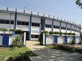
There are two public colleges in the city limits: Gangarampur College and Gangarampur B.Ed. College.
Gangarampur College was established in 1981 in Gangarampur as a co-educational institute of learning with the objective of expanding the scope of higher education in a remote district of West Bengal. The college has moved forth to achieve the fruition of its goals in the following years and was accredited by NAAC C++ in September 2004.[5]
Schools
There are many public and private schools in the city limits: Gangarampur High School, Gangarampur Girls High School, Holy Cross Primary (co-ed) and Girls High School, St. Joseph High School, Chhittaranjan English Medium School, Kid's Hall, Rabrindra Smriti Bidyapith, Indranarayanpur Colony High School, Belbari High School, Shemrock Disha Play School, and Saraswati Shishu Mandir.
Economy
The economy of Gangarampur is driven by agricultural farming, small business, handloom and handloom based handicrafts. Important handloom potential areas are located in Boaldaha, Korial, Belberi-I, Belberi-II and various parts in Gangarampur Municipality area. Important handloom products include cotton ordinary saree, cotton Mala saree, ladies churidar set (churidars are tightly fitting trousers worn by both men and women in South Asia), gents kurta/panjabi and Shirting Than (Length of cloth) etc. According to the annul report published by Directorate of Textiles (Govt. of West Bengal) Bordangi (located near Gangarampur College) area has 588, where as rest of Gangarampur area has 252 looms.[6]
Transportations
Gangarampur is connected to Kolkata, Siliguri, Jalpaiguri, Malda, Balurghat and other major places in North Bengal by both bus and train services.
Bus
The only State highway passes through Gangarampur is SH 10. The state highway has recently been upgraded into National Highway 512 by Government of India.[7] This highway connects Gangarampur with National Highway 34 (India), which is the only other National Highway in Dakshin Dinajpur. This newly upgraded 99 kilometers long National Highway is stretched from Gajol to Hilli (near Indo/Bangladesh). Both private and public night bus services to Kolkata, Siliguri, Jalpaiguri, Cooch Behar are available. Buses to Balurghat, Raiganj and Malda run frequently throughout the day. Recently the new bus terminal near the old one was inaugurated.

Train
The railway station in Gangarampur was built earlier in 2004 and the first train ran on December 30, 2004. The station is located at the south side of the town near Gangarampur College. Few express trains like Gour Express, Balurghat-Kolkata Express, New Jalpaiguri-Balurghat Intercity express stops at Gangarampur railway station.
Health
The subdivisional hospital is located at the eastern side of the town near Kaldighi. The hospital runs with 250 beds. For improvement of overall health care services in Dakshin Dinajpur district many intervention-specific projects/programmes like improvement of infrastructural facilities in the secondary level hospitals, reducing the prevalence of Malaria, creating awareness about HIV, to look after the reproductive and child health of the below poverty line people in the municipal areas, providing free treatment/medicine to them etc. are taken under consideration.[8]
Sports
The favorite sports in Gangarampur are cricket and football like other parts of [West Bengal]. As in the rest of India, cricket is popular in Gangarampur and is played on grounds and in streets throughout the city. The Football Club ground, a vast field that serves as the city's largest park, hosts several minor football and cricket games.
Gangarampur stadium is located by the state highway (SH 10) near Kaldighi. The stadium was built in early twenty first century.
Language
Bengali is the main language of Gangarampur. Other languages are Hindi, English, Marwari, Bhojpuri etc. The principal communities are Hindus and Muslims, constituting the major portion of the population. There are many temples, mosques and churches around the town for religious practice.
Attractions
Bangarh

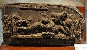
Bangarh where the University of Calcutta started archaeological excavation under the guidance of Prof. Kunja Gobinda Goswami in the year 1931 and were later taken up by the Archaeological Survey of India and relics including copper plate inscriptions, metallic coins, pots and such other articles used during the period of Maurya dynasty, Palas and Senas were unearthed wave the flag of ancient history of this great geographical identity which was once a part of Pundravardhana. Perfection of quality of hundreds of sand-stone and black-stone sculptures of different mythological God & Goddess discovered in course of excavation of ponds in different adjoining areas of Gangarampur, Harirampur, Banshihari, Kushmandi, and Tapan, could be the points of reverence for any European sculptor of mediaeval period. Some of the objects found in the excavation were: manuscript of King Naipala (11th century AD), statue of Darpal, pillars of Lord Vishnu Temple, walls of an ancient building, many statues and small relics, grave of the Turkish warrior Bakhtiar Khilji. Also a road was found called the Usha Haran Road, which is believed to be the road used by the grandson of Lord Krishna, Anirudha, to kidnap his wife Usha.[9]
Kaldighi
Two big lakes namely Kaldighi and Dhaldighi are located at the east side of the town. These are (mainly Kaldighi) now the abode of many migratory birds that signal the potentials of lake-tourism as well as eco-tourism and at the same time provide living to a lot many through pisciculture and cater to the demand of local sweet-water fish in a large number of markets throughout North Bengal.[10]

Dargah of Shah Ata
The brick-built Dargah was built probably in c.14th Cent. AD. It consists of a square Mausoleum now roofless. The Mausoleum encloses the grave of Mollah Atar-Uddin or Shah Ata. The lower portion of the structure is built of stone. It is actually a mosque with niches and not a Dargah. There are four inscriptions in Arabic fixed on the wall. Traces of older remains indicate the existence of a temple of the Pala period at the site.[11]
References
- ↑ Falling Rain Genomics, Inc - Gangarampur
- ↑ http://www.ddinajpur.nic.in/Tourist_Interest/tourist_interest.html
- ↑ http://www.weatherbase.com/weather/weather.php3?s=596066&cityname=Balurghat-West-Bengal-India Retrieved 24 June 2014.
- ↑ http://www.wbdma.gov.in/HTM/MUNI_ALL_ULBs.htm
- ↑ http://college.globalshiksha.com/Gangarampur-College/700890225940286
- ↑ http://www.westbengalhandloom.org/htm/c_ddinaj1.html
- ↑ http://morth.nic.in/showfile.asp?lid=366
- ↑ http://www.ddinajpur.nic.in/Health_Centres/health_centres.html
- ↑ http://wbnorthbengaldev.gov.in/HtmlPage/South_Dinajpur.aspx
- ↑ http://www.ddinajpur.nic.in/Dm_Desk/dm_desk.html
- ↑ http://www.asikolkata.in/dinajpur.aspx
Cities, towns and locations in Dakshin Dinajpur district | |||||||
|---|---|---|---|---|---|---|---|
| Cities, municipal and census towns |
| ||||||
| Related topics |
| ||||||