GNSS augmentation
Augmentation of a global navigation satellite system (GNSS) is a method of improving the navigation system's attributes, such as accuracy, reliability, and availability, through the integration of external information into the calculation process. There are many such systems in place and they are generally named or described based on how the GNSS sensor receives the external information. Some systems transmit additional information about sources of error (such as clock drift, ephemeris, or ionospheric delay), others provide direct measurements of how much the signal was off in the past, while a third group provide additional vehicle information to be integrated in the calculation process.
Satellite-based augmentation system
A satellite-based augmentation system (SBAS) is a system that supports wide-area or regional augmentation through the use of additional satellite-broadcast messages. Such systems are commonly composed of multiple ground stations, located at accurately-surveyed points. The ground stations take measurements of one or more of the GNSS satellites, the satellite signals, or other environmental factors which may impact the signal received by the users. Using these measurements, information messages are created and sent to one or more satellites for broadcast to the end users. SBAS is sometimes synonymous with WADGPS, wide-area DGPS.[1]
Implementations
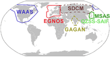
For details on how various SBAS are implemented, please see the following articles:
- The Wide Area Augmentation System (WAAS), operated by the United States Federal Aviation Administration (FAA).
- The European Geostationary Navigation Overlay Service (EGNOS), operated by the ESSP (on behalf of EU's GSA).
- The Multi-functional Satellite Augmentation System (MSAS) system, operated by Japan's Ministry of Land, Infrastructure and Transport Japan Civil Aviation Bureau (JCAB).
- The Quasi-Zenith Satellite System (QZSS), proposed by Japan.
- The GPS Aided Geo Augmented Navigation (GAGAN) system being operated by India.[2][3]
- The GLONASS System for Differential Correction and Monitoring (SDCM), proposed by Russia.
- The Satellite Navigation Augmentation System (SNAS), proposed by China.
- The Wide Area GPS Enhancement (WAGE), operated by the United States Department of Defense for use by military and authorized receivers.
- The commercial StarFire navigation system, operated by John Deere.
- The commercial Starfix DGPS System and OmniSTAR system, operated by Fugro.
- The GPS·C, short for GPS Correction, was a Differential GPS data source for most of Canada maintained by the Canadian Active Control System, part of Natural Resources Canada - now decommissioned.
Ground-based augmentation system
Each of the terms ground-based augmentation system (GBAS) and ground-based regional augmentation system (GRAS) describe a system that supports augmentation through the use of terrestrial radio messages. As with the satellite based augmentation systems detailed above, ground based augmentation systems are commonly composed of one or more accurately surveyed ground stations, which take measurements concerning the GNSS, and one or more radio transmitters, which transmit the information directly to the end user from the ground up thus avoiding the constraints associated with GEO Satellites at high latitudes.
Generally, GBAS is localized, supporting receivers within 23 nautical miles, and transmitting in the very high frequency (VHF) band.
The shorter the distance between the ground station that calculates the differential corrections to the inbound plane, the higher the accuracy is likely to be. There are stricter Safety requirements on GBAS systems relative to SBAS systems since GBAS is intended mainly for the landing phase where real-time accuracy and signal integrity control is critical, especially when weather deteriorates to the extent that there is no visibility (CAT-I/II/III conditions) for which SBAS is not intended or suitable.[4]
Various ground-based augmentation systems
- International Civil Aviation Organization Ground-Based Augmentation System (GBAS) applies to precision approach landing of civil aircraft. Originally this system was called the Local Area Augmentation System (LAAS)
- The US Nationwide Differential GPS System (NDGPS), An augmentation system for users on U.S. land and waterways.[5]
- See also, the Differential GPS (DGPS) Wikipedia page
Additional navigation sensors
The augmentation may also take the form of additional information being blended into the position calculation. Many times the additional avionics operate via separate principles than the GNSS and are not necessarily subject to the same sources of error or interference. A system such as this is referred to as an aircraft-based augmentation system (ABAS) by the ICAO.
The additional sensors may include:
- eLORAN receivers
- Automated Celestial navigation systems
- Inertial Navigation Systems
- Simple Dead reckoning systems (composed of a gyro compass and a distance measurement)
See also
- Assisted GPS (A-GPS)
- GNSS enhancement
References
- ↑ Kee, C., Parkinson, B. W., and Axelrad, P. (1991), "Wide area differential GPS", Navigation, Journal of the Institute of Navigation, 38, 2 (Summer, 1991), <http://ion.org/search/view_abstract.cfm?jp=j&idno=207>
- ↑ http://isro.gov.in/pressrelease/scripts/pressreleasein.aspx?Jan03_2014
- ↑ http://www.thehindu.com/news/national/kerala/gagan-system-ready-for-operations/article5565700.ece
- ↑ http://www.gps.gov/multimedia/presentations/2011/09/ICG/lawrence.pdf
- ↑ US Government page on GPS augmentation systems
External links
- Airservices Australia GBAS and GNSS website
- US Government page on GPS augmentation systems
- Canada to Decommission DGPS System
- flygls.net lists all GLS sites worldwide
| Operational | |
|---|---|
| Historical | |
| In development | |
| GNSS augmentation | |
| GNSS augmentation historical | |
| Related topics | |