Fulwood, Lancashire
| Fulwood | |
 Fulwood Barracks |
|
 Fulwood |
|
| Population | 28,353 (2011) |
|---|---|
| OS grid reference | SD5431 |
| District | Preston |
| Shire county | Lancashire |
| Region | North West |
| Country | England |
| Sovereign state | United Kingdom |
| Post town | PRESTON |
| Postcode district | PR2 |
| Dialling code | 01772 |
| Police | Lancashire |
| Fire | Lancashire |
| Ambulance | North West |
| EU Parliament | North West England |
| UK Parliament | Wyre and Preston North |
| Preston | |
|
|
Coordinates: 53°46′46″N 2°41′37″W / 53.779444°N 2.693611°W
Fulwood is an affluent township in Lancashire, England, forming much of the northern half of the unparished area of the City of Preston district. It had a population of 33,171 in 2001.[1]
For several reasons, despite its close proximity to Preston, it has remained distinctly separated. Historically, Fulwood was governed independently from Preston until 1974. Furthermore, since the majority of the area is encompassed under The Fulwood Conservation Area, it has remained geographically separate from Preston.[2] Fulwood, in 2011, had a population of 28,353 and is made up of five wards.
History
Fulewde, 1199; Fulewude, 1228; Fulwode, 1297. The extract below by John Marius Wilson, Imperial Gazetteer of England and Wales (1870–72) described Fulwood and its history during its early Victorian foundations: "FULWOOD, a township-chapelry in Lancaster parish, Lancashire; on the Lancaster and Preston railway, 1.5 mile N of Preston. It has a station on the railway; and its post town is Preston. Acres, 2077. Real property, £6,218. Pop. in 1851, 1,748; in 1861, 2,313. Houses, 172. This was part of the ancient royal forest of Fulwood, now enclosed; and Preston race-ground was part of it. Extensive barracks are here. The living is a vicarage in the diocese of Manchester." [3]
Economy and society
Fulwood has expanded in the 20th century, and has been popular with housing and business developers, with its close links to the M6 and M55 motorways. Since the 1970s when the Central Lancashire New Town was proposed, large sites have been made available for development, such as Longsands, which is a residential area, and "East Preston", where many businesses are currently located, including the Lancashire Evening Post (LEP), Asda, Royal Mail sorting office, Independent Inspections, Xchanging, CPC,[4] EDS and Holiday Inn.[5] The B6241 (Eastway) provides a vital route, bypassing much of the residential and central areas of Preston, and a road via Longsands connects it to the M6 motorway (at junction 31A which was opened in the 1990s) and the Bluebell Way business park on the boundary with Brookfield.
It is also the home of the Royal Preston Hospital, Sharoe Green Hospital was also in Fulwood until its closure in 2004.[6]
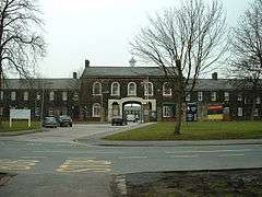
Fulwood Barracks has been the home of the Queen's Lancashire Regiment, and other regiments, and is the site of the Queen's Lancashire Regiment Museum.[7]
A notable former resident was Major John Rouse Merriott Chard, of the Royal Engineers, V.C., officer commanding at Rorke's Drift in 1879. He was posted to Preston between 1887 and 1892, and is recorded in the 1891 Census living at 80 Victoria Road, Fulwood.[8][9]
Since the mass migration of Indians, Fulwood has been a popular place of residence for well-known, and wealthy families of the Vora Patel community, many of whom have resided here for several generations. Many families of this community amassed great wealths during the economic prosperity of the textiles industry in Northern England and, to this day, retain much of their wealth and have bought many of Lancashire's historic properties.[10]
Architecture

Fulwood is one of the greener parts of the Preston area, however it is nevertheless a fairly built up area, with buildings dating back to the Victorian gentrification of the region, and earlier. Due to large investments during the late Victorian era, Fulwood was an area of much development by wealthy Preston industrialists. Some of the finest Victorian buildings of Lancashire can be found in Fulwood,[11] such as the Fulwood Barracks, Fulwood Union Workhouse, and Harris Orphanage. Many of the larger houses in Fulwood were also built during the Victorian period, particularly those in the Nooklands cul-de-sac.
Amenities
Fulwood has a large number of local amenities. The neighbourhood has a large number of local shops, primary and high schools, pubs, libraries, a large Asda supermarket and Booths supermarket, Preston's main hospital, a college, parks, and many other services.
Parks
The town has seven different greens, consisting of Conway Drive, South Drive, Mill Lane, Sherwood, Levensgarth Avenue, Tower Lane and Andertons Way. This makes Fulwood one of the greener districts of Preston.
Education
State-funded schools
State education is administered by Lancashire County Council.
Primary schools
- Fulwood and Cadley Primary School
- Fulwood St Peter's Church of England Primary School
- Harris Primary School
- Kennington Primary School
- Longsands Community Primary School
- Queen's Drive Primary School
- Our Lady and St Edwards Catholic Primary School
- St Clare's Catholic Primary School
- St Anthony's Catholic Primary School
- Sherwood Primary School
Secondary schools
- Archbishop Temple School
- Corpus Christi Catholic High School
- Fulwood Academy
- Our Lady's Catholic High School
Special schools
- Moorbrook School
Independent schools
Independent junior and prep schools
- Highfield Priory School
- St Pius X Preparatory School
Further education
The main campus of Preston's College is located in Fulwood on St Vincent's Road.
Politics

The electoral wards which make up the area of Fulwood are; Sharoe Green, College, Cadley, Greyfriars and Garrison. Parts of the rural wards, named as Preston Rural East and Preston Rural North, were in the former Preston Rural District. Preston Council meetings are hosted every 3 months classified as Area Forum Meetings, of which Fulwood is the Northern Area Forum.
Until 2010, the wards which make up Fulwood were split between a number of parliamentary constituencies due to local government boundaries changing between the Boundary Commission for England's reports on parliamentary boundaries. Thus, Fulwood was split unevenly between three constituencies;
- Ribble Valley - parts of Rural North and Rural East, Greyfriars, Garrison, the northern parts of College, Sharoe Green, Cadley
- Preston - southern parts of College ward
- Fylde - elements of Preston Rural North and West.
Following their review of parliamentary representation in Lancashire, the Boundary Commission have moved the whole of Fulwood into a new constituency of Wyre and Preston North.
For Preston city council elections, see Preston local elections
Between 1894 and 1974 Fulwood was governed by Fulwood Urban District council which was merged with other districts under the Local Government Act 1972 to become the new non-metropolitan district of the Borough (now City) of Preston.
Sport
The local cricket teams are Grasshoppers CC (Social Side) and Fulwood & Broughton CC who play in the Palace Shield. In 2005 they were the most successful cricket side at club level in Britain, winning nine trophies between the senior and junior teams.
The local football team is Fulwood Amateurs F.C. who play in the West Lancashire League.
The local rugby team is Preston Grasshoppers R.F.C. who play in the national league structure.
Fulwood Leisure Centre is on Black Bull Lane.
Transport
Fulwood railway station was once in Gamull Lane, on the border between Fulwood and Ribbleton, on the Longridge Branch Line. It was renamed Ribbleton railway station in 1900 and closed in 1930.
Fulwood is served by several bus routes operated by Preston Bus, Stagecoach in Lancashire and Stagecoach in Lancaster. These services include routes (Preston Bus) 19, 19A, 22, 23, 86 and the 88A/88C Orbit service & (Stagecoach) 4, 4A, 4C & 40/41 services.
There are cycle paths from Fulwood through Lancaster to Carnforth as well, and people are encouraged to use them.
See also
References
- ↑ Office for National Statistics : Census 2001 : Table KS01 : Usual Resident Population Brookfield (part); Cadley, College, Garrison; Greyfriars; and Sharoe Green wards. Retrieved 24 May 2010
- ↑ "Fulwood Conservation Area Appraisal". Archived from the original on 29 October 2013. Retrieved 22 October 2016.
- ↑ http://www.genuki.org.uk/big/eng/LAN/Fulwood/
- ↑ Lancashire County Council: Lancashire Profile
- ↑ Northern Britain Property Partners NBPP, Valtos, Collective Investment Schemes And Property Asset Management, Northern Britain Property Partners NBPP, Valtos, Collective Investment Schemes And Property Asset Management
- ↑ History of Sharoe Green Hospital, accessed 7 September 2009
- ↑ Fulwood Barracks, accessed 7 September 2009
- ↑ Greave, Adrian (2003), Rorke's Drift, Cassell, p.231
- ↑ 1891 Census RG12/3448/schedule 296
- ↑ http://www.preston.gov.uk/sitesforpreston
- ↑ 'The parish of Lancaster: Fulwood', A History of the County of Lancaster: Volume 7 (1912), pp. 137-138.
| Wikimedia Commons has media related to Fulwood, Lancashire. |
Geography of the City of Preston district | |||||||||||
|---|---|---|---|---|---|---|---|---|---|---|---|
| Cities |  | ||||||||||
| Suburbs | |||||||||||
| Villages | |||||||||||
| Parishes | |||||||||||
| Topography |
| ||||||||||