Fukaya Station
Fukaya Station 深谷駅 | |
|---|---|
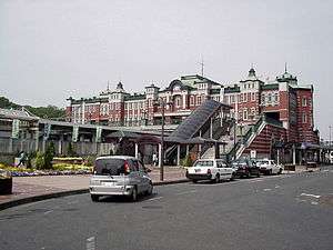 North entrance to Fukaya Station, August 2012 | |
| Location |
Kashiwaza 3-1-8 Nishijima-cho, Fukaya-shi, Saitama-ken 埼玉県深谷市西島町三丁目1-8 Japan |
| Operated by |
|
| Line(s) | ■ Takasaki Line |
| Platforms | 1 side platform, 2 island platform |
| History | |
| Opened | 1883 |
| Traffic | |
| Passengers (FY2014) | 9832 daily |
Fukaya Station (深谷駅 Fukaya-eki) is a railway station on the Takasaki Line operated by East Japan Railway Company (JR East) in Fukaya, Saitama, Japan.
Lines
Fukuaya Station is served by the Takasaki Line, with through Shonan-Shinjuku Line and Ueno-Tokyo Line services to and from the Tokaido Line. It is 45.8 kilometers from the nominal starting point of the Takasaki Line at Ōmiya.
Layout
The station has one side platform and one island platform serving three tracks, connected by a footbridge, with an elevated station building located above the platforms. The station has a "Midori no Madoguchi" staffed ticket office.
Platforms
| 1 | ■ Takasaki Line | for Ōmiya, Urawa, and Ueno Ueno-Tokyo Line (Tokaido Line, Ito Line through service) for Tokyo, Yokohama, Atami, and Ito |
| 2, 3 | ■ Takasaki Line | for Kumagaya, Kagohara, Takasaki, and Maebashi |
Adjacent stations
| « | Service | » | ||
|---|---|---|---|---|
| Takasaki Line/Ueno-Tokyo Line | ||||
| Kagohara | Urban Rapid | Okabe | ||
| Kagohara | Local | Okabe | ||
| Shonan-Shinjuku Line | ||||
| Kagohara | Special Rapid | Okabe | ||
| Kagohara | Rapid | Okabe | ||
Statistics
The daily average usage for 2014 was 9,832 people[1]
History
The station opened on 21 October 1883. The station became part of the JR East network after the privatization of the JNR on 1 April 1987. A new station building modeled after Tokyo Station was completed in August 1996, with its brick built by Japan Brick Company. Bricks used in the Marunouchi side of the Tokyo Station building are produced by this company.
Surrounding area
- Karasawa River
- Fukaya City Hall
- Fukaya Post Office
- Japan National Route 17
See also
References
- ↑ 各駅の乗車人員 (2014年度) [Station passenger figures (Fiscal 2014)] (in Japanese). Japan: East Japan Railway Company. 2015. Retrieved 5 October 2015.
External links
| Wikimedia Commons has media related to Fukaya Station. |
Coordinates: 36°11′29″N 139°16′53″E / 36.1913°N 139.2813°E