Fryeburg, Maine
| Fryeburg | |
|---|---|
| Town | |
|
| |
| Motto: "The Oldest Town in Oxford County"[1] | |
 Fryeburg Location within the state of Maine | |
| Coordinates: 44°0′59″N 70°58′52″W / 44.01639°N 70.98111°WCoordinates: 44°0′59″N 70°58′52″W / 44.01639°N 70.98111°W | |
| Country | United States |
| State | Maine |
| County | Oxford |
| Incorporated | 1777 |
| Area[2] | |
| • Total | 65.89 sq mi (170.65 km2) |
| • Land | 58.33 sq mi (151.07 km2) |
| • Water | 7.56 sq mi (19.58 km2) |
| Population (2010)[3] | |
| • Total | 3,449 |
| • Estimate (2012[4]) | 3,416 |
| • Density | 59.1/sq mi (22.8/km2) |
| Time zone | Eastern (EST) (UTC-5) |
| • Summer (DST) | EDT (UTC-4) |
| ZIP codes | 04037 |
| Area code(s) | 207 |
| Website | Fryeburg, Maine |

Fryeburg is a town in Oxford County, Maine, United States. The population was 3,449 at the 2010 census. Fryeburg is home to Fryeburg Academy, a private preparatory school, and the International Musical Arts Institute. The town is also site of the Fryeburg Fair, which each October attracts approximately 300,000 visitors.
History
The area was once a major Abenaki Indian village known as Pequawket, meaning "crooked place," a reference to the large bend in the Saco River. It was inhabited by the Sokokis tribe, whose territory along the stream extended from what is now Saco on the coast, to Conway, New Hampshire in the White Mountains. In 1706, Chief Nescambious would be the only Indian knighted by the French.[5] For a while the tribe was not hostile to English settlements, even hiring British carpenters to build at Pequawket a 14-foot (4.3 m) high palisade fort as protection against their traditional enemy, the Mohawks. In 1713, Sokokis sachems signed the Treaty of Portsmouth to ensure peace with English colonists. Eventually however, relations with the English soured. Later on, during Father Rale's War, Pequawket was attacked in the Battle at Pequawket on May 8, 1725 by John Lovewell and his militia.[6] Lovewell was killed, as were Chief Paugus and others. The tribe subsequently abandoned their village and moved to Canada.[7]
The township was granted on March 3, 1762 by the Massachusetts General Court to Colonel Joseph Frye of Andover, Massachusetts. Colonists called it Pigwacket, a corruption of its former Indian name. The first permanent settlement was in 1763 by Nathaniel Smith and his family from Concord, New Hampshire, although it is said that John Stevens, Nathaniel Merrill and a slave named Limbo spent the winter of 1762 here. Many pioneers were veterans of the French and Indian Wars. When a portion of the grant was discovered to lie in New Hampshire, replacement land was granted as Fryeburg Addition in what is now part of Stow. On the eve of American independence, the Province of Massachusetts Bay granted township privileges to Fryeburg. These were recognized and validated by the Continental Massachusetts government on January 11, 1777, when Fryeburg was incorporated.[8]
It began as a strategic frontier outpost, and the earliest town in the White Mountain region. Excellent soil helped Fryeburg develop into a prosperous agricultural center, and the first gristmill was established using Saco River water power in 1766. Other mills and factories produced lumber, leather, harness, tinware, cheese and canned vegetables. After the Civil War, the Portland and Ogdensburg Railroad passed through the town, bringing tourists escaping the heat and pollution of cities. Inns, hotels and boarding houses were built. Tourists began arriving by automobile after designation of the Theodore Roosevelt International Highway in 1919 (identified as United States Route 302 since 1935).[9] Fryeburg is today a year-round resort area. It is also an academic town. Fryeburg Academy, a private preparatory school, was founded in 1792. Before his career as a statesman, Daniel Webster taught for a year at the school, one of the oldest of its type in the nation.[10] In 1924, Dr. Abraham Krasker founded Indian Acres Camp For Boys. Two years later, he founded the less influential Forest Acres Camp For Girls. In 1997, the International Musical Arts Institute was founded at Fryeburg.
 Main Street c. 1910
 Fryeburg Academy in 1913
 Intervale c. 1920
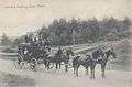
Geography
According to the United States Census Bureau, the town has a total area of 65.89 square miles (170.65 km2), of which, 58.33 square miles (151.07 km2) of it is land and 7.56 square miles (19.58 km2) is water.[2] Located beside the New Hampshire border, Fryeburg is drained by the Saco River.
The town is served by U.S. Route 302, Maine State Route 5 and Maine State Route 113.
Climate
This climatic region is typified by large seasonal temperature differences, with warm to hot (and often humid) summers and cold (sometimes severely cold) winters. According to the Köppen Climate Classification system, Fryeburg has a humid continental climate, abbreviated "Dfb" on climate maps.[11]
Demographics
| Historical population | |||
|---|---|---|---|
| Census | Pop. | %± | |
| 1810 | 1,004 | — | |
| 1820 | 1,057 | 5.3% | |
| 1830 | 1,352 | 27.9% | |
| 1840 | 1,536 | 13.6% | |
| 1850 | 1,523 | −0.8% | |
| 1860 | 1,623 | 6.6% | |
| 1870 | 1,507 | −7.1% | |
| 1880 | 1,633 | 8.4% | |
| 1890 | 1,418 | −13.2% | |
| 1900 | 1,376 | −3.0% | |
| 1910 | 1,282 | −6.8% | |
| 1920 | 1,283 | 0.1% | |
| 1930 | 1,592 | 24.1% | |
| 1940 | 1,726 | 8.4% | |
| 1950 | 1,926 | 11.6% | |
| 1960 | 1,874 | −2.7% | |
| 1970 | 2,208 | 17.8% | |
| 1980 | 2,715 | 23.0% | |
| 1990 | 2,968 | 9.3% | |
| 2000 | 3,083 | 3.9% | |
| 2010 | 3,449 | 11.9% | |
| Est. 2014 | 3,398 | [12] | −1.5% |
2010 census
As of the census[3] of 2010, there were 3,449 people, 1,368 households, and 920 families residing in the town. The population density was 59.1 inhabitants per square mile (22.8/km2). There were 1,844 housing units at an average density of 31.6 per square mile (12.2/km2). The racial makeup of the town was 94.4% White, 0.6% African American, 0.2% Native American, 2.9% Asian, 0.3% from other races, and 1.7% from two or more races. Hispanic or Latino of any race were 1.4% of the population.
There were 1,368 households of which 30.8% had children under the age of 18 living with them, 49.8% were married couples living together, 12.6% had a female householder with no husband present, 4.8% had a male householder with no wife present, and 32.7% were non-families. 26.5% of all households were made up of individuals and 11.1% had someone living alone who was 65 years of age or older. The average household size was 2.40 and the average family size was 2.86.
The median age in the town was 44 years. 22.9% of residents were under the age of 18; 8.3% were between the ages of 18 and 24; 19.7% were from 25 to 44; 33% were from 45 to 64; and 16.1% were 65 years of age or older. The gender makeup of the town was 48.4% male and 51.6% female.
2000 census
As of the census[14] of 2000, there were 3,083 people, 1,245 households, and 841 families residing in the town. The population density was 52.8 people per square mile (20.4/km²). There were 1,648 housing units at an average density of 28.2 per square mile (10.9/km²). The racial makeup of the town was 98.15% White, 0.32% Black or African American, 0.13% Native American, 0.23% Asian, 0.16% Pacific Islander, 0.16% from other races, and 0.84% from two or more races. Hispanic or Latino of any race were 1.17% of the population.
In the town the population was spread out with 23.5% under the age of 18, 6.5% from 18 to 24, 26.0% from 25 to 44, 28.3% from 45 to 64, and 15.7% who were 65 years of age or older. The median age was 42 years. For every 100 females there were 91.0 males. For every 100 females age 18 and over, there were 89.6 males.
The median income for a household in the town was $34,333, and the median income for a family was $40,128. Males had a median income of $26,469 versus $20,486 for females. The per capita income for the town was $18,658. About 9.7% of families and 11.6% of the population were below the poverty line, including 11.6% of those under age 18 and 11.9% of those age 65 or over.
Sites of interest
Education
Fryeburg is part of Maine School Administrative District #72. Gary L. MacDonald is the Superintendent.
Schools is this district include Brownfield-Denmark, C. A. Snow, Molly Ockett, New Suncook School and Fryeburg Academy.[15]
Transportation and commerce
U.S. Route 302 in Fryeburg is the second largest point of entry for highway traffic into the state of Maine, next to Interstate 95 in Kittery.
The town hosts a small airport, called Eastern Slopes Regional Airport. It is the home of Dearborn Precision Tubular Products, a major manufacturer of precision tubular products. The town is the state's second-largest producer of potatoes after Aroostook County. It is also home to Har-Mac Steel, a manufacturer of structural reinforcing materials for the construction industry. Their products are being used in the construction of tunnels, bridges and major buildings in locations such as Chicago, New York and Puerto Rico.
Notable people
- Charles S. Benton, US congressman[16]
- Nathaniel S. Benton, politician[17]
- John W. Dana, governor of Maine[18]
- Judah Dana, US senator[19]
- Joseph Frye, military leader and town founder[20]
- Spalding Gray, actor, author[21]
- David Hastings, state senator
- Eastman Johnson, artist[22]
- Clarence E. Mulford, creator of Hopalong Cassidy[23]
- Nescambious, Abenaki tribal chief
- James R. Osgood, publisher
- Robert Peary, Arctic explorer
- James W. Ripley, US congressman[24]
- Eric Rosenblith, violinist
- Daniel Webster, US senator and secretary of state[25]
- James S. Wiley, US congressman
References
- ↑ "Fryeburg, Maine". Fryeburg, Maine. Retrieved August 26, 2012.
- 1 2 "US Gazetteer files 2010". United States Census Bureau. Retrieved 2012-12-16.
- 1 2 "American FactFinder". United States Census Bureau. Retrieved 2012-12-16.
- ↑ "Population Estimates". United States Census Bureau. Retrieved 2013-07-06.
- ↑ Maine League of Historical Societies and Museums (1970). Doris A. Isaacson, ed. Maine: A Guide 'Down East'. Rockland, Me: Courier-Gazette, Inc. p. 402.
- ↑ John Grenier. The Far Reaches of Empire. University of Oklahoma Press. 2008
- ↑ Town History of Fryeburg, Maine
- ↑ Coolidge, Austin J.; John B. Mansfield (1859). A History and Description of New England. Boston, Massachusetts. pp. 133–137.
- ↑ Tracy, A.W. (December 1996) [1921]. "Highway Display's America's Glories". Theodore Roosevelt International Highway, Montana (PDF). Montana Department of Transportation. p. 7. Retrieved August 21, 2008.
- ↑ Varney, George J. (1886), Gazetteer of the state of Maine. Fryeburg, Boston: Russell
- ↑ Climate Summary for Fryeburg, Maine
- ↑ "Annual Estimates of the Resident Population for Incorporated Places: April 1, 2010 to July 1, 2014". Retrieved June 4, 2015.
- ↑ "Census of Population and Housing". Census.gov. Retrieved June 4, 2015.
- ↑ "American FactFinder". United States Census Bureau. Retrieved 2008-01-31.
- ↑ "Maine School Administrative District #72". Maine School Administrative District #72. Retrieved 2012-06-06.
- ↑ "BENTON, Charles Swan, (1810–1882)". Biographical Directory of the United States Congress. Retrieved December 13, 2013.
- ↑ Harlow, Samuel Ralph and Boone, H. H. (1867). Life Sketches of the State Officers, Senators, and Members of the Assembly of the State of New York, in 1867. Weed, Parsons, Printers. p. 50.
- ↑ "Maine Governor John Winchester Dana". National Governors Association. Retrieved December 13, 2013.
- ↑ "DANA, Judah, (1772–1845)". Biographical Directory of the United States Congress. Retrieved December 13, 2013.
- ↑ WILLIAMSON, WILLIAM D. (1832). THE HISTORY OF THE STATE OF MAINE; FROM ITS FIRST DISCOVERY, A.D. 1602, TO THE SEPARATION, A.D. 1820, INCLUSIVE. WILLIAM D. WILLIAMSON. p. 459.
- ↑ Gray, Spalding (2012). The Journals of Spalding Gray. Random House LLC. p. 40.
- ↑ "Johnson, Eastman". American National Biography. Retrieved December 13, 2013.
- ↑ "Clarence E. Mulford home, Fryeburg, ca. 1930". Maine Memory Network. Retrieved December 13, 2013.
- ↑ "RIPLEY, James Wheelock, (1786–1835)". Biographical Directory of the United States Congress. Retrieved December 13, 2013.
- ↑ "WEBSTER, Daniel, (1782–1852)". Biographical Directory of the United States Congress. Retrieved December 13, 2013.
External links
| Wikimedia Commons has media related to Fryeburg, Maine. |
- Town of Fryeburg, Maine
- Fryeburg Public Library
- Fryeburg Academy
- Fryeburg Fair
- International Musical Arts Institute
- Map of Fryeburg Village in 1878 from the Maine Memory Network
- Maine Genealogy: Fryeburg, Oxford County, Maine
Municipalities and communities of Oxford County, Maine, United States | ||
|---|---|---|
| Towns |  | |
| Plantations | ||
| Unorganized territories | ||
| CDPs | ||
| Other villages | ||