Frosterley
Coordinates: 54°43′40″N 1°57′32″W / 54.7278°N 1.9588°W

Frosterley is a village in County Durham, in England. It is situated in Weardale, on the River Wear close to its confluence with Bollihope Burn; between Wolsingham and Stanhope; 18 miles west of Durham City and 26 miles southwest of Newcastle-upon-Tyne.[1] In the 2001 census Frosterley had a population of 705.[2]
Frosterley is on the Weardale Railway. Heritage trains currently run to Stanhope, Wolsingham and Witton-le-Wear
History
The area has been inhabited since Mesolithic times: Mesolithic flints and Neolithic stones axes have been found in the vicinity. A bronze spearhead was found in a local quarry dating to the late Bronze Age circa 1000 BC. The village itself has medieval origins and although the original houses have long been replaced the village still retains its medieval pattern.
On the north of the village are the remains of St Botolph’s Chapel. What remains is an earthwork mound surrounded by a modern housing estate (Kirk Rise). The site was excavated in 1995, before the estate was built, and the probable remains of an ecclesiastical building was discovered. It is thought this was built around the 10th or 11th century and dedicated to the east Anglican saint St. Botolph who lived in the 7th century and was very popular in medieval times though little is now known about him. It is thought the village originally may have been named after the saint. The earliest reference to its current name occurs in the Close Rolls of 1239, where it appears as Frosterlegh meaning the clearing in the forest.

Frosterley Marble
A black limestone containing fossil corals of the Carboniferous Period, some 325 million years ago. When cut and polished the result is a beautiful ornate stone, much desired for church decoration, particularly during the Middle Ages
Frosterley Marble has been taken from the Rogerley Quarry for more than 700 years; the decorative columns found in Durham Cathedral date from about 1350. Examples of Frosterley Marble can be found at several places in the village, the church of St Michael and All Saints, the railway station and behind the car park in the centre of the village.
Rogerley Mine
The Rogerley mine, located in a 19th century limestone quarry, is the only mine known to be operated on a commercial basis solely for mineral specimens in the UK.
Gallery
 Frosterley centre |
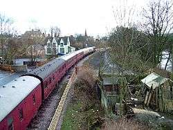 Weardale Railway |
References
- ↑ Ordnance Survey: Landranger map sheet 92 Barnard Castle & Richmond (Teesdale) (Map). Ordnance Survey. 2011. ISBN 9780319228982.
- ↑ "Wear Valley Settlement Summary Sheets" (PDF). Durham County Council. Archived from the original (PDF) on October 7, 2007. Retrieved 14 October 2016.
External links
| Wikimedia Commons has media related to Frosterley. |
- St Botolph
- Weardale Railway
- Stone in Archaeology database
- Frosterley Marble leaflet (North Pennines Rockworks project)
- Rogerley Mine information and photo galleries at Mindat.org
- Frosterley Marble