Friedrichswalde
For other uses, see Friedrichswalde (disambiguation).
| Friedrichswalde | |
|---|---|
 Friedrichswalde | |
Location of Friedrichswalde within Barnim district  | |
| Coordinates: 53°02′0″N 13°43′0″E / 53.03333°N 13.71667°ECoordinates: 53°02′0″N 13°43′0″E / 53.03333°N 13.71667°E | |
| Country | Germany |
| State | Brandenburg |
| District | Barnim |
| Municipal assoc. | Joachimsthal (Schorfheide) |
| Government | |
| • Mayor | Bernhard Ströbele (Einzelbewerber) |
| Area | |
| • Total | 44.89 km2 (17.33 sq mi) |
| Population (2015-12-31)[1] | |
| • Total | 807 |
| • Density | 18/km2 (47/sq mi) |
| Time zone | CET/CEST (UTC+1/+2) |
| Postal codes | 16247 |
| Dialling codes | 033367 |
| Vehicle registration | BAR |
| Website | www.amt-joachimsthal.de |
Friedrichswalde is a municipality in the district of Barnim in Brandenburg in Germany. It is situated in the Schorfheide nature reserve.
Demography
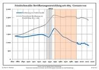
Development of population since 1875 within the current boundaries (Blue line: Population; Dotted line: Comparison to population development of Brandenburg state; Grey background: Time of Nazi rule; Red background: Time of communist rule)
|
|
|
|
Detailed data sources are to be found in the Wikimedia Commons.[3]
Personality

Wilhelm Friedrich Graf von Redern around 1845
- Friedrich Wilhelm von Redern (1802-1883), Prussian general manager and politician, owner of good Glambeck
- Paul Thränert (1875-1960), trade unionist, born in Friedrichswalde
- Bruno Endrejat (1908-1945), resistance fighter against Nazism, born in Friedrichswalde
References
- ↑ "Bevölkerung im Land Brandenburg nach amtsfreien Gemeinden, Ämtern und Gemeinden 31. Dezember 2015 (Fortgeschriebene amtliche Einwohnerzahlen auf Grundlage des Zensus 2011)". Amt für Statistik Berlin-Brandenburg (in German). 2016.
- ↑ Boundaries as of 2013
- ↑ Population Projection Brandenburg at Wikimedia Commons
Towns and municipalities in Barnim district | ||
|---|---|---|
This article is issued from Wikipedia - version of the 10/20/2016. The text is available under the Creative Commons Attribution/Share Alike but additional terms may apply for the media files.