Friary Park
Friary Park is a 9 hectare formal Edwardian park in Friern Barnet in the London Borough of Barnet. It is owned and managed by Barnet Council, and has a children's playground, tennis courts, a bowling green, a pitch and putt, a skateboard park and a cafe. It is a Site of Local Importance for Nature Conservation, and has received a Green Flag Award.[1][2][3]
The site was home to the Knights Hospitaller in the Middle Ages, and of Friern Barnet Manor House from the sixteenth century.[2] The name Friary Park was adopted in the 1870s and it was opened to the public in 1910. In 2010 the Friends of Friary Park and other local societies organised centenary celebrations.[4]
The cafe is housed in the nineteenth century Gothic Revival Friary House, which is otherwise mostly unused, although Barnet Council announced in 2010 that work is underway to convert it to a base for the local police Safer Neighbourhood Team.[5]
A prominent feature is a statue, the 'Bringer of Peace', dedicated to the memory of King Edward VII, and erected on 7 May 1910, the day after his death.[2]
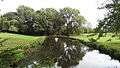
Its most interesting features ecologically are ancient oak trees and a small stream called Blacketts Brook, a tributary of Pymme's Brook.[1]
There is access from Torrington Park, Friary Road and Friern Barnet Lane.
North Middlesex Golf Course Ponds
The North Middlesex Golf Course is adjacent to the park to the north at Grid Ref TQ269 930. Blacketts Brook runs through two ponds on the golf course before entering the park. Palmate newts, which are rare in London, breed in the ponds, which are a Site of Borough Importance for Nature Conservation, Grade II. The reserve is not open to the public.[6]
Gallery
-

Statue of Peace
-

Formal garden
-

Children's playground and cafe
-

Friary House
-

Bridge over the small stream
-

Woods
-

Avenue
-
Pond on North Middlesex Golf Course
See also
Notes
- 1 2 "Friary Park". Greenspace Information for Greater London. 2006. Retrieved 9 September 2012.
- 1 2 3 Friary Park, Barnet Online
- ↑ "iGiGL – helping you find London's parks and wildlife sites". Greenspace Information for Greater London. 2006.
- ↑ Friary Park Centenary Celebrations, Hendon Central Town Talk
- ↑ Partnership policing project well underway, Barnet Council press release 19 July 2010
- ↑ Hewlett, Jan; et al. (1997). Nature Conservation in Barnet. London Ecology Unit. pp. 80–81. ISBN 1 871045 27 4.
External links
Further reading
- Hewlett, Janet (1997). Nature Conservation in Barnet. London Ecology Unit. ISBN 1 871045 27 4.
Coordinates: 51°37′07″N 0°09′45″W / 51.6185°N 0.1624°W