Fremont Island
| Fremont Island | |
| Private Land | |
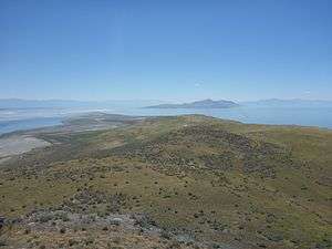 View from Castle Rock - looking south | |
| Country | United States |
|---|---|
| State | Utah |
| County | Weber County, Utah |
| Coordinates | 41°09′56″N 112°20′23″W / 41.16556°N 112.33972°WCoordinates: 41°09′56″N 112°20′23″W / 41.16556°N 112.33972°W |
| Highest point | |
| - location | Castle Rock |
| - elevation | 1,522 m (4,993 ft) |
| Lowest point | |
| - location | Great Salt Lake |
| - elevation | 1,279 m (4,196 ft) |
| Length | 8.57 km (5 mi) |
| Width | 2.76 km (2 mi) |
| Area | 11.9 km2 (5 sq mi) |
 Fremont Island Map | |
Fremont Island,[1] at 2,943.04 acres (12 km2), is an island located in Great Salt Lake in the U.S. state of Utah. Privately owned, Fremont Island is the lake's third largest island after Stansbury Island and Antelope Island.
Human history
Fremont Island is named for military leader and explorer John C. Frémont.[2]
In April 1848, a year after Mormon pioneers made it to the Salt Lake valley, Albert Carrington and other pioneers boated around the area and dubbed it “Castle Island” due to a throne-like shape at the north end of the island.
It was first dubbed Fremont Island in 1850, when Capt. Howard Stansbury surveyed the Great Salt Lake. That name eventually stuck.
In 1859, two Farmington men placed 153 head of sheep on the island, even calling it “Miller’s Island” after one of the men, Dan Miller.
In 1862, a grave robber named Jean Baptiste was banished to the island by Brigham Young after Baptiste was arrested for robbing at least 300 graves, according to an article by Yvette D. Isom for History Blazer.
After three weeks there, Baptiste escaped. Cattle herders on the island found a heifer that had been killed and tanned for leather, as well as pieces of wood torn from a ranch house on the island. It was believed Baptiste attempted to escape by making a makeshift raft.
However, his whereabouts and fate of his breakout attempt were never known.
In the early 1870s, the island became a spot for precious metal mining — though only 38 claims were made over a two-year span.
In 1886, a judge named Uriah J. Wenner moved his family to the island. Wenner was diagnosed with tuberculosis and moved his family to Fremont Island because of its remote location.
He and his family remained there until he died in 1891 and was even buried on the island. His wife, Kate, left the island and eventually remarried. When she died in 1942, her ashes were placed next to Uriah's on the island.
In 2003 the island was leased by the Barrow Land and Livestock company. Exotic species of animals were brought to the island with the intent to provide unique hunting opportunities.[3]
In October 2013 a feral pig was spotted near the Antelope Island causeway. This prompted the state authorities to investigate and find populations of illegal species. The state and owners then proceeded to hunt the remaining animals by air to prevent the potential spread to the mainland.[4]
Access
Fremont Island is privately owned and permission is required for access. The island is accessible via an exposed land bridge when the Great Salt Lake water level is lower than 4,195 feet in elevation. The start point of the land bridge is approximately 1 mile east of the Antelope Island Marina and can be accessed via the Antelope Island causeway.[5]
Flora
There are certain plant species that occur on Fremont Island, and there is historic evidence that some species that were earlier documented to occur on the island are no longer present. For example, explorers who visited this island in the mid-1800s noted the presence of abundant "onions" which they identified as Calochortus luteus. However, this name was applied to plants that were later renamed as other species.[6] While it is unlikely that the California endemic C. luteus occurred on Fremont Island, it is clear that some species of Calochortus once present is now extinct.
Notes
- ↑ "Fremont Island". www3.co.weber.ut.us. Weber County GIS. 9 September 2014. Retrieved 6 September 2014.
- ↑ Gannett, Henry (1905). The Origin of Certain Place Names in the United States. Govt. Print. Off. p. 132.
- ↑ Weist, Larry (17 March 2003). "Fremont Island". www.deseretnews.com. Deseret News. Retrieved 28 August 2014.
- ↑ Prettyman, Brett (31 October 2013). "Feral pigs killed after one headed for Antelope Island". www.sltrib.com. The Salt Lake Tribune. Retrieved 28 August 2014.
- ↑ Baskin, Robert (March 2005). "Bathymetric Map of the South Part of Great Salt Lake, Utah, 2005d". pubs.usgs.gov. United States Geological Survey. Retrieved 9 September 2014.
- ↑ C. Michael Hogan. 2009. Yellow Mariposa Lily: Calochortus luteus, GlobalTwitcher.com, ed. N. Stromberg
References
- Miller, David E. (June 1980). "Great Salt Lake: A Historical Sketch". In Gwynn, J. Wallace. Great Salt Lake: A Scientific, Historical, and Economic Overview. Bulletin 116. Utah Geological Survey. ISBN 1-55791-083-9. LCCN 80623880. OCLC 6659366.
- http://www.ksl.com/?sid=41585301&nid=148&title=the-interesting-history-of-great-salt-lakes-disappointing-island