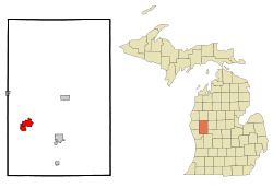
Fremont, Michigan
| Fremont, Michigan | |
|---|---|
| City | |
| Motto: "Now And Always - A Fine City, A Great Community"[1] | |
 | |
| Coordinates: 43°28′0″N 85°56′54″W / 43.46667°N 85.94833°W | |
| Country | United States |
| State | Michigan |
| County | Newaygo |
| Area[2] | |
| • Total | 4.72 sq mi (12.22 km2) |
| • Land | 3.42 sq mi (8.86 km2) |
| • Water | 1.30 sq mi (3.37 km2) |
| Elevation | 817 ft (249 m) |
| Population (2010)[3] | |
| • Total | 4,081 |
| • Estimate (2012[4]) | 4,046 |
| • Density | 1,193.3/sq mi (460.7/km2) |
| Time zone | Eastern (EST) (UTC-5) |
| • Summer (DST) | EDT (UTC-4) |
| ZIP codes | 49412-49413 |
| Area code(s) | 231 |
| FIPS code | 26-30700[5] |
| GNIS feature ID | 0626466[6] |
| Website | City of Fremont, Michigan |
Fremont is a city in Newaygo County in the U.S. state of Michigan. The population was 4,081 at the 2010 census.
History
The first inhabitants of the Fremont area were Native Americans. A group of settlers led by Daniel Weaver first settled the area in 1855, the Weaver homestead serving as the first post office and public school. In November 1855, Fremont Township was established and named in honor of John C. Fremont,[7] western explorer and Republican Party candidate for United States President. Weaver and his fellow settlers cleared the dense timber in order to farm. Early in the 1870s, Dutch immigrant families came from Holland and Muskegon, Michigan; and Fremont continues to recognize its early Dutch heritage in local festivals and pageants.
Due to rich stands of virgin timber, lumbering became a major industry, and a railroad spur soon linked Fremont to the national rail network. The lumbering industry declined in the 1860s because of the American Civil War; and in 1871, Fremont experienced a major forest fire that caused extensive damage, especially to the lumber mills. Nevertheless, Fremont rebuilt and was even able to supply some lumber to rebuild Chicago after the Great Fire of 1871.
Also in the mid-1870s, the Gerber family moved to Fremont and eventually created a major canning industry. In the 1890s the Gerbers began processing local farm produce and formed the Fremont Canning Company. In 1928 the plant started to manufacture baby foods, and the company changed its name to Gerber Products Company. Gerber now controls over 80% of the U.S. baby food market, and the plant produces baby food for over 20 foreign countries.
Geography
According to the United States Census Bureau, the city has a total area of 4.72 square miles (12.22 km2), of which 3.42 square miles (8.86 km2) is land and 1.30 square miles (3.37 km2) is water.[2]
Demographics
| Historical population | |||
|---|---|---|---|
| Census | Pop. | %± | |
| 1880 | 902 | — | |
| 1890 | 1,097 | 21.6% | |
| 1900 | 1,331 | 21.3% | |
| 1910 | 2,009 | 50.9% | |
| 1920 | 2,180 | 8.5% | |
| 1930 | 2,157 | −1.1% | |
| 1940 | 2,520 | 16.8% | |
| 1950 | 3,056 | 21.3% | |
| 1960 | 3,384 | 10.7% | |
| 1970 | 3,465 | 2.4% | |
| 1980 | 3,672 | 6.0% | |
| 1990 | 3,875 | 5.5% | |
| 2000 | 4,224 | 9.0% | |
| 2010 | 4,081 | −3.4% | |
| Est. 2015 | 4,036 | [8] | −1.1% |
2010 census
As of the census[3] of 2010, there were 4,081 people, 1,781 households, and 1,107 families residing in the city. The population density was 1,193.3 inhabitants per square mile (460.7/km2). There were 1,968 housing units at an average density of 575.4 per square mile (222.2/km2). The racial makeup of the city was 94.5% White, 0.5% African American, 0.3% Native American, 1.1% Asian, 0.1% Pacific Islander, 2.2% from other races, and 1.3% from two or more races. Hispanic or Latino of any race were 4.6% of the population.
There were 1,781 households of which 29.4% had children under the age of 18 living with them, 43.6% were married couples living together, 14.8% had a female householder with no husband present, 3.8% had a male householder with no wife present, and 37.8% were non-families. 33.5% of all households were made up of individuals and 14.7% had someone living alone who was 65 years of age or older. The average household size was 2.27 and the average family size was 2.88.
The median age in the city was 39.5 years. 25.1% of residents were under the age of 18; 8.3% were between the ages of 18 and 24; 22.8% were from 25 to 44; 24.6% were from 45 to 64; and 19.4% were 65 years of age or older. The gender makeup of the city was 44.7% male and 55.3% female.
2000 census
As of the census[5] of 2000, there were 4,224 people, 1,788 households, and 1,140 families residing in the city. The population density was 1,268.3 per square mile (489.8/km²). There were 1,943 housing units at an average density of 583.4 per square mile (225.3/km²). The racial makeup of the city was 96.59% White, 0.38% African American, 0.50% Native American, 0.99% Asian, 0.05% Pacific Islander, 0.47% from other races, and 1.02% from two or more races. Hispanic or Latino of any race were 1.96% of the population.
There were 1,788 households out of which 30.1% had children under the age of 18 living with them, 50.0% were married couples living together, 11.4% had a female householder with no husband present, and 36.2% were non-families. 32.4% of all households were made up of individuals and 16.9% had someone living alone who was 65 years of age or older. The average household size was 2.34 and the average family size was 2.97.
In the city the population was spread out with 26.9% under the age of 18, 7.9% from 18 to 24, 25.2% from 25 to 44, 20.4% from 45 to 64, and 19.6% who were 65 years of age or older. The median age was 37 years. For every 100 females there were 82.2 males. For every 100 females age 18 and over, there were 76.4 males.
The median income for a household in the city was $32,246, and the median income for a family was $42,578. Males had a median income of $37,872 versus $23,203 for females. The per capita income for the city was $19,475. About 8.8% of families and 12.2% of the population were below the poverty line, including 20.0% of those under age 18 and 7.5% of those age 65 or over.
Economy
Gerber Products Company is located in Fremont. The Gerber Products Company was originally started as the Fremont Canning Company. Fremont is known as "The Baby Food Capital of the World".[10]
Arts and culture
The annual Baby Food Festival takes place in July.
Fremont was central to the plot of the 1966 Eurospy film, Secret Agent Super Dragon, which was later featured on Mystery Science Theater 3000 (MST3K). However, the fictional Fremont was described as a college town with canyons.
Infrastructure
Transportation
Notable people
- Bert Zagers, former running back and defensive back for the Washington Redskins of the National Football League.[11]
- Joe Berger, current center for the Minnesota Vikings of the National Football League.[12]
- Frank Daniel Gerber, founder of the Fremont Canning Company, and later the Gerber Products Company.[13]
- Dan Gerber, American poet.[14]
- Lola Blanc, American singer and model.
- Alex Gorsky, CEO of Johnson & Johnson.
References
- ↑ "City of Fremont, Michigan". City of Fremont, Michigan. Retrieved August 26, 2012.
- 1 2 "US Gazetteer files 2010". United States Census Bureau. Retrieved 2012-11-25.
- 1 2 "American FactFinder". United States Census Bureau. Retrieved 2012-11-25.
- ↑ "Population Estimates". United States Census Bureau. Retrieved 2013-06-03.
- 1 2 "American FactFinder". United States Census Bureau. Retrieved 2008-01-31.
- ↑ "US Board on Geographic Names". United States Geological Survey. 2007-10-25. Retrieved 2008-01-31.
- ↑ "Profile for Fremont, Michigan, MI". ePodunk. Retrieved August 26, 2012.
- ↑ "Annual Estimates of the Resident Population for Incorporated Places: April 1, 2010 to July 1, 2015". Retrieved July 2, 2016.
- ↑ "Census of Population and Housing". Census.gov. Retrieved June 4, 2015.
- ↑ "Fremont Area Chamber of Commerce". Fremont Area Chamber of Commerce. Retrieved August 26, 2012.
- ↑ "Bert Zagers". NFL Enterprises LLC. Retrieved August 26, 2012.
- ↑ "Joe Berger". NFL Enterprises LLC. Retrieved August 26, 2012.
- ↑ "Dan Gerber". Soylent Communications. Retrieved August 26, 2012.
- ↑ "Dan Gerber". The Poetry Foundation. Retrieved January 13, 2014.
External links
- Fremont Public Schools Homepage
- City of Fremont (city government)
- Fremont Area Chamber of Commerce
- Fremont Area District Library
- Spectrum Health Gerber Memorial Hospital
Municipalities and communities of Newaygo County, Michigan, United States | ||
|---|---|---|
| Cities | 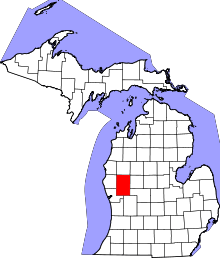 | |
| Village | ||
| Charter township | ||
| General law townships | ||
| Unincorporated communities | ||
| Footnotes | ‡This populated place also has portions in an adjacent county or counties | |
Coordinates: 43°28′03″N 85°56′31″W / 43.46750°N 85.94194°W