Fremantle Harbour


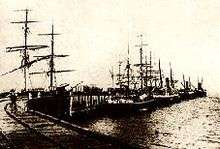
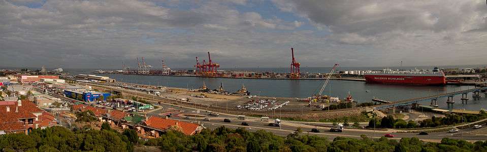
Fremantle Harbour is Western Australia's largest and busiest general cargo port[1] and an important historical site. The inner harbour handles a large volume of sea containers, vehicle imports and livestock exports, cruise shipping and naval visits, and operates 24 hours a day.
Fremantle consists of the Inner Harbour, which is situated on the mouth of the Swan River; the Outer Harbour, which is 20 km south at Kwinana in Cockburn Sound and handles bulk cargo ports, grain, petroleum, liquefied petroleum gas, alumina, mineral sands, fertilisers, sulphur and other bulk commodities; and Gage Roads which is the anchorage between Rottnest Island and the mainland. The Inner Harbour includes northern and southern wharves named North Quay and Victoria Quay respectively. All of this area is managed by the Fremantle Port Authority, a government trading enterprise.
History
Fremantle's port role began immediately the Swan River Colony was founded in 1829, but the entrance to the Swan River estuary was blocked by a rocky bar, which made the mouth of the river virtually impassable for seagoing vessels.[2] The first steamship to enter the port was HMS Driver on 4 December 1845.[2]
Fremantle shipping was served by the Long Jetty that extended into the open sea, where Bathers Beach is today. Cargo was offloaded onto the jetty and then taken down Cliff Street in Fremantle's West End. It was loaded onto barges that sailed up the river on the westerly sea breeze and back to Fremantle on easterly winds. Later it was transported by rail.[3][4] Sailors disliked the Long Jetty: in 1892 Captain D.B. Shaw of the American barque Saranac described it as "terrible":
"... entered and fought against putting the vessel alongside jetty to discharge. It is a terrible place. No place to put a vessel. No shelter whatever. All the ships have to lay and discharge at the wharf or pay lighterage.... It is blowing a gale from the SW ... and takes all our time to hold her.... She had done considerable damage to herself.... It is certainly the worst place I or anyone else ever saw. No place to send a ship of this size.... Any man who would come or send a ship a second time is a damned ass."[4]
Alternatives
British marine engineer John Coode advised John Forrest an outer harbour near Rous Head, or one that would stretch south from Arthur's Head, could be built. Coode ruled out building a port in the river mouth as he believed it would continually silt up due to lateral sand drift. In 1887 the Fremantle Chamber of Commerce pushed hard for the southern scheme to be chosen, but the Colony could not raise the half-million pounds which were estimated what such an initiative would cost. By 1891 Forrest was examining another proposal: an offshore facility at Owen Anchorage south of Fremantle.
But by then Charles Yelverton O'Connor had been appointed the Colony's Engineer-in-Chief, and decided the best option was an inner harbour built in the mouth of the Swan River. The discovery of gold in Western Australia meant a working port was urgently needed, Parliament finally accepted O'Connor's plan after much political haggling, the capital was raised in London and preliminary work commenced late in 1892.[4]
Harbour development
The first stage of the harbour works began with a ceremony in which the Governor's wife, Lady Robinson, tilted the first truck load of rubble for the North Mole.[5] Blasting and dredging the rocky bar created a channel, dredging deepened the river basin, and two moles were built to protect the harbour entrance. Land was reclaimed so quays and warehouses could be built.[5] The inner harbour was opened on 4 May 1897 when the steamer Sultan drawing just one foot of water[6] with Lady Forrest at the wheel was the first ship to enter the partly built port.[4]
"While the harbour has been deepened, and facilities extended and modernised over the years, the basic structure of the Inner Harbour remains essentially unchanged to this day, testament to the boldness, brilliance and foresight of its designer."[2]
There are two lighthouses on either side of the entrance to the harbour, the green coloured South Mole Lighthouse, in operation since 1903, and the red painted North Mole Lighthouse, which commenced operation in 1906, located at the end of the westernmost point of the harbour.
Mail packets
As the port neared completion, Forrest lobbied the British to have Fremantle as the port of call for the Mail Packets. Victoria and New South Wales fought for the retention of Albany as the Mail Packet port, as they were fearful they would lose business. Forrest threatened Western Australia may stay out of the proposed federation of Australian colonies unless they agreed. On 3 August 1900, Forrest won when the Postmaster-General in London informed the Post Master-General in Perth that Fremantle would be substituted for Albany as the port of call for Mail Packets. Ten days later the Orient Steam Navigation Company's RMS Ormuz, homeward bound from Sydney to London, was the first British mail carrier to enter and berth in Fremantle Harbour. In 1901 Fremantle surpassed Albany for the first time in total tonnage of ships and the following year in the number of ships when it cleared 410 ships (1,045,170 tons) to Albany's 248 ships (540,910 tons).[4]
Rail link
The railway from the harbour was constructed in the 1880s, and continued to be developed with railway workshops (later moved to Midland Junction), railway sheds, railway marshalling yards, locomotive depots, and in 1907 Fremantle railway station was opened.[7]
Defences and wartime role

During World War II, the harbour accommodated scores of Allied naval vessels on active service. Battleships, troop transports, hospital ships and support vessels, including many passenger ships, were seconded into the war effort. Visitors to Fremantle during the conflict included passenger liners and converted troop carriers RMS Queen Elizabeth and RMS Queen Mary. Because of their size neither was able to take up an inner harbour berth, and instead anchored in Gage Roads. Other well-known ships to visit included the RMS Strathaird, RMS Strathnaver, RMS Orion and RMS Otranto.
In 1940 boom defences were installed in the harbour as a security measure and anti-aircraft installations were built. By January 1941 an anti-submarine indicator loop was installed between Swanbourne and Rottnest to warn of any ships passing over it.[8] Outer harbour defences included a anti-submarine net spanning 9370 metres of seabed from Woodman Point to Garden Island along Parmelia Bank, as well as another indicator loop 183 metres further north.[9]
Following the losses of battleships HMS Prince of Wales and HMS Repulse on 10 December 1941 and the fall of Singapore in March 1942, many ships sought refuge at Fremantle; at times 30 were at anchor in Gage Roads.
"In the inner harbour, it was ... a common sight to see up to as many as four vessels of substantial size lying in tier, and it was due solely to the circumstances forced upon the port and the prevailing weather conditions that such a state of affairs could be permitted. Altogether, some 75 vessels were using the inner and outer harbours at one and the same time, and in the fortnight ending 20th March, a total of 103 vessels, Naval and merchant, and mainly seeking refuge, arrived at the port. Until these vessels could be ordered to some other destination, acute conditions persisted at the port for some weeks."[10]
Fremantle Submarine Base was the largest submarine base in the southern hemisphere during World War II. The first United States submarines arrived at Fremantle in 1942, the US Navy built a submarine repair facility on North Quay the next year, and until 1945 the port accommodated more than 170 submarines from the U.S., British and Dutch navies.[10] The slipway on the south side of the entrance to the harbour where the Western Australian Maritime Museum is now located was also an important part of the wartime role of the harbour.[11]
Victoria Quay

A statue honouring C. Y. O'Connor was erected on Victoria Quay on 23 June 1911. It now stands near the entrance to the Fremantle Ports administration building on Cliff Street.[5]
During a waterside clash between police and workers on Bloody Sunday, 4 May 1919, lumper Tom Edwards was struck on the head with a police baton. He died three days later, leaving a wife and three children.[12] A memorial fountain by Pietro Porcelli[13] was erected in Edwards' memory that year, and was moved to Fremantle's Kings Square in 1968.
The Fremantle Passenger Terminal was constructed in time for the 1962 British Empire and Commonwealth Games.[14]
North Quay
North Quay is the portion of Fremantle Harbour on the northern banks of the Swan River, built in the late 1890s this area is now primarily used for container shipping. On the western edges is Rous Head a smaller harbour used for vessel maintenance which also includes the Rottnest Island Ferry Terminal
Gage Roads
Gage Roads serve as a shipping lane and anchorage for sea traffic heading towards the port of Fremantle. The area is the most northern of one of four coastal basins formed from the flooding of a depression between Pleistocene aeolianite ridges running north-south, and the subsequent deposition of east-west Holocene banks. The seabed of Gage Roads is covered by seagrass.
Cockburn Sound
Cockburn Sound is an inlet that extends from the south of the mouth of the Swan River for about 25 km to Cape Peron near Rockingham. The total area of the sound is about 100 km². It is bounded on the east by the mainland suburbs of Cockburn and Kwinana, on the west by Garden Island and Carnac Island, and includes several rocky outcrops and reefs.
Signalling equipment

In 1928 the Signal Station at Fremantle was moved from Arthur Head to a site on Cantonment Hill. This building was replaced in 1956 by a new structure, whose functions were superseded in 1964 by the opening of a signal station on the new Port Authority administration building,[15] which was opened by Premier David Brand on 5 March.[16]
South Mole
Built in the 1890s from the southern point of the Swan River mouth is a breakwater to ensure a safe anchorage for vessels in the Inner Harbour. A light house was added in 1903 initially shining a white it conflicted with the Woodman point light house, leading to the South Mole light to change to a green beacon.
North Mole
Built in the 1890s the North Mole was extended almost immediately after completion and on a number of occasions since, the most recent being in the late 1980s, to allow for the addition of an entrance into the Rous Head harbour that was being constructed. Situated on the western end of the mole is a light house initially this shone with green light but was changed to red after it became necessary to alter the white light on the south mole to green.
References
- ↑ "Port at a Glance". Fremantle Ports.
- 1 2 3 "Early History". Fremantle Ports.
- ↑ Dena Garratt. "Fremantle Long Jetty". WA Museum. Retrieved 2008-12-29.
- 1 2 3 4 5 John Longley. "The First Mail Steamer". Fremantle Ports.
- 1 2 3 "C.Y. O'Connor". Fremantle Ports.
- ↑ "
 Chapter 21". History of West Australia. Wikisource. 1897. p. 339.
 - ↑ "About Freo". About Fremantle website.
- ↑ "Leighton Battery Assessment Documentation". Heritage Council of Western Australia. 28 August 1999. Retrieved 12 August 2016.
- ↑ Matt Carter and Ross Anderson (March 2010). "Cockburn Sound World War II Anti-submarine Net" (PDF). Western Australian Museum. Retrieved 12 August 2016.
- 1 2 "1930 - 1939". Fremantle Ports.
- ↑ Sherriff, Jacqui.(2002) Fremantle South Slipway : a vital World War II defence facility. Fremantle studies, No.2 (2002), p.106-119, http://henrietta.liswa.wa.gov.au/record=b2078343~S2
- ↑ Wikisource:The Fremantle Wharf Crisis of 1919
- ↑ "Artwork in Public Places Tour". Fremantle Focus website.
- ↑ "Cruise Ship Visit". Fremantle Ports.
- ↑ "18 September 1928". Fremantle Ports.
- ↑ "1964". Fremantle Ports.
Further reading
- Britton, David. (1987) History of the port The West Australian, 2 May 1987, p. 35, 36
- Davidson, Dean. (2000) The inner harbour of the port of Fremantle. (History of the inner harbour through to the formulation of the current port development plan) Western planner (West Perth, W.A.) Mar. 2000, p. 10-11,
- Institution of Engineers, Australia. Western Australia Division. (1989) Construction of Fremantle Harbour, 1892-1901 : the Institution of Engineers, Australia National Historic Engineering Landmark nomination submitted by Western Australia Division, I.E. (Aust.) and Fremantle Port Authority. West Perth, W.A : The Division. ISBN 0-909421-24-2 (pbk.)
- Merrin, Gary. (1997) Centenary port to celebrate. Road patrol Apr./May 1997, p. 10-12
- Tull, Malcolm. (1997) A community enterprise : the history of the Port of Fremantle, 1897 to 1997 St John's, Nfld.: International Maritime Economic History Association. ISBN 0-9681288-2-3 (pbk.)
External links
![]() Media related to Fremantle Harbour at Wikimedia Commons
Media related to Fremantle Harbour at Wikimedia Commons
- Fremantle Ports – official website
Coordinates: 32°03′S 115°44′E / 32.050°S 115.733°E