Franklin Township, Carbon County, Pennsylvania
| Franklin Township | |
| Settlement | |
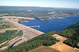 Beltzville Dam | |
| Country | United States |
|---|---|
| State | Pennsylvania |
| County | Carbon |
| Elevation | 574 ft (175.0 m) |
| Coordinates | 40°51′00″N 75°39′59″W / 40.85000°N 75.66639°WCoordinates: 40°51′00″N 75°39′59″W / 40.85000°N 75.66639°W |
| Area | 15.7 sq mi (40.7 km2) |
| - land | 15.2 sq mi (39 km2) |
| - water | 0.5 sq mi (1 km2) |
| Population | 4,262 (2010) |
| Density | 281.2/sq mi (108.6/km2) |
| Timezone | EST (UTC-5) |
| - summer (DST) | EDT (UTC-4) |
| Area code | 610 |
 Location of Franklin Township in Carbon County | |
 Location of Franklin Township in Pennsylvania | |
 Location of Pennsylvania in the United States | |
| Website: www | |
Franklin Township is a township in Carbon County, Pennsylvania, United States. The population was 4,262 at the 2010 census.[1] A portion of Beltzville State Park is in Franklin Township.
Geography
The township is located in southern Carbon County and is drained by the Lehigh River on its western boundary. The northern boundary runs along the base of Bear Mountain. Pohopoco Creek is the primary tributary of the Lehigh within the township and is impounded in the township by Beltzville Dam to form Beltzville Lake. Villages in the township include Beltzville, East Weissport, Harrity, Long Run, North Weissport, and Walcksville.
According to the United States Census Bureau, the township has a total area of 15.7 square miles (40.6 km2), of which 15.2 square miles (39.3 km2) is land and 0.50 square miles (1.3 km2), or 3.27%, is water.[1] Franklin Township hosts the Mahoning Valley Interchange of Interstate 476 with U.S. Route 209. Pennsylvania Route 248 connects US 209 in Weissport with the Allenstown–Bethlehem area via Lehigh Gap.
Neighboring municipalities
- Parryville (southwest)
- Mahoning Township (west)
- Weissport (west)
- Lehighton (west)
- Jim Thorpe (northwest)
- Penn Forest Township (north)
- Towamensing Township (east)
- Lower Towamensing Township (south)
Demographics
As of the census[2] of 2000, there were 4,243 people, 1,671 households, and 1,256 families residing in the township. The population density was 291.4 people per square mile (112.5/km²). There were 1,819 housing units at an average density of 124.9/sq mi (48.2/km²). The racial makeup of the township was 98.87% White, 0.07% African American, 0.14% Native American, 0.35% Asian, 0.09% from other races, and 0.47% from two or more races. Hispanic or Latino of any race were 0.45% of the population.
There were 1,671 households, out of which 28.8% had children under the age of 18 living with them, 64.0% were married couples living together, 6.9% had a female householder with no husband present, and 24.8% were non-families. 19.5% of all households were made up of individuals, and 8.5% had someone living alone who was 65 years of age or older. The average household size was 2.54 and the average family size was 2.90.
In the township the population was spread out, with 21.4% under the age of 18, 6.5% from 18 to 24, 29.9% from 25 to 44, 27.7% from 45 to 64, and 14.6% who were 65 years of age or older. The median age was 40 years. For every 100 females there were 101.1 males. For every 100 females age 18 and over, there were 98.5 males.
The median income for a household in the township was $43,106, and the median income for a family was $50,323. Males had a median income of $34,801 versus $24,429 for females. The per capita income for the township was $19,166. About 2.6% of families and 4.3% of the population were below the poverty line, including 5.4% of those under age 18 and 6.2% of those age 65 or over.
References
- 1 2 "Geographic Identifiers: 2010 Demographic Profile Data (G001): Franklin township, Carbon County, Pennsylvania". U.S. Census Bureau, American Factfinder. Retrieved April 6, 2015.
- ↑ "American FactFinder". United States Census Bureau. Retrieved 2008-01-31.
External links
Municipalities and communities of Carbon County, Pennsylvania, United States | ||
|---|---|---|
| Boroughs | 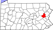 | |
| Townships | ||
| CDPs | ||
| Unincorporated communities | ||
| Footnotes | ‡This populated place also has portions in an adjacent county or counties | |