Frévent
| Frévent | ||
|---|---|---|
|
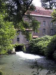
Blondel watermill, housing the Wintenberger Museum | ||
| ||
 Frévent | ||
|
Location within Hauts-de-France region  Frévent | ||
| Coordinates: 50°16′38″N 2°17′20″E / 50.2772°N 2.2889°ECoordinates: 50°16′38″N 2°17′20″E / 50.2772°N 2.2889°E | ||
| Country | France | |
| Region | Hauts-de-France | |
| Department | Pas-de-Calais | |
| Arrondissement | Arras | |
| Canton | Auxi-le-Château | |
| Intercommunality | Région de Frévent | |
| Government | ||
| • Mayor (2008–2014) | Jean-François Théret | |
| Area1 | 15.23 km2 (5.88 sq mi) | |
| Population (2007)2 | 4,037 | |
| • Density | 270/km2 (690/sq mi) | |
| Time zone | CET (UTC+1) | |
| • Summer (DST) | CEST (UTC+2) | |
| INSEE/Postal code | 62361 / 62270 | |
| Elevation |
62–145 m (203–476 ft) (avg. 79 m or 259 ft) | |
|
1 French Land Register data, which excludes lakes, ponds, glaciers > 1 km² (0.386 sq mi or 247 acres) and river estuaries. 2 Population without double counting: residents of multiple communes (e.g., students and military personnel) only counted once. | ||

Frévent is a commune in the Pas-de-Calais department in the Hauts-de-France region of France.
Geography
A farming town situated in the valley of the Canche river, 20 miles (32.2 km) west of Arras, at the junction of the D946, the D939 and the D941 roads.
History
The year 1137 saw the establishment of a Cistercian abbey by the Count de Saint-Pol at the hamlet of Cercamp.
The town was invaded in 1537 by the French, and the castle was burned down in 1543 by the Duke of Vendôme.
Frévent was partially destroyed in 1944 during the Second World War.
Population
The inhabitants are called Fréventins.
| Year | 1962 | 1968 | 1975 | 1982 | 1990 | 1999 | 2007 |
|---|---|---|---|---|---|---|---|
| Population | 4386 | 4531 | 4322 | 4217 | 4121 | 3952 | 4037 |
| From the year 1962 on: No double counting—residents of multiple communes (e.g. students and military personnel) are counted only once. | |||||||
Places of interest
- The church of St. Hilaire, dating from the sixteenth century.
- The church of St. Vaast, dating from the twentieth century.
- The chateau at Cercamp, dating from the nineteenth century.
- The abbey and park at Cercamp.
- A former flour mill.
- The Louis Ducatel Museum, housing works of the painter Louis Ducatel, local archaeology, costumes and sculptures.
- The Wintenberger Museum, with a history of flour mills and a collection of tools and farm equipment.
See also
References
External links
| Wikimedia Commons has media related to Frévent. |
- Frévent on the Quid website (French)
This article is issued from Wikipedia - version of the 11/6/2016. The text is available under the Creative Commons Attribution/Share Alike but additional terms may apply for the media files.