Fort Washington Way
  | |
|---|---|
| Interstate 71 / U.S. Route 50 | |
| Maintained by | ODOT |
| Length | 0.9 mi[1] (1.4 km) |
| West end |
|
| East end |
|
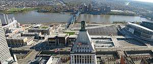
Fort Washington Way is an approximately 0.9-mile-long (1.4 km) section of freeway in downtown Cincinnati, Ohio, United States. The eight-lane divided highway is a concurrent section of Interstate 71 (I-71) and U.S. Route 50 (US 50) that runs from west to east from an interchange with I-75 at the Brent Spence Bridge to the Lytle Tunnel and Columbia Parkway.[1]
Fort Washington Way is named after Fort Washington, a fort that preceded the establishment of Cincinnati.[2] One of the city's first freeways, it was conceived in 1946 as the Third Street Distributor in conjunction with a major urban renewal project along the riverfront.[3] It opened in 1961 after one of the most expensive road construction projects per mile in the United States.[4] Fort Washington Way's complex system of ramps made it the most crash-prone mile of urban freeway in Ohio. During the late 1990s, it was rebuilt with a simpler, more compact configuration, improving traffic safety and facilitating the riverfront's redevelopment as The Banks.[2]
Route description

Fort Washington Way begins at a complex interchange with I-75 at the northern end of the Brent Spence Bridge. It ends a short distance later at a fork in the road. I-71 curves eight degrees to the north before entering the Lytle Tunnel, while US 50 continues east on Columbia Parkway via the Third Street Viaduct.[1][5]
The entire highway lies in a 25-foot-deep (7.6 m), 150-foot-wide (46 m) trench parallel to Second Street and Pete Rose Way to the south and Third Street to the north. Together, these roadways form a collector-distributor system. There are five overpasses along Fort Washington Way; the overpasses at either end are cable-stayed. The Riverfront Transit Center runs parallel to Fort Washington Way, in a tunnel beneath Second Street.[6]
A 30-foot-tall (9.1 m) flood wall and pumping station protect Fort Washington Way from Ohio River floodwaters.[6] The pump is activated when the river reaches 60 feet (18 m), as measured from the Roebling Suspension Bridge.[7]
History
Background and planning
The eastern terminus of present-day Fort Washington Way was originally the site of an army fortress, Fort Washington, from 1789 to 1803. During much of the 19th century, the area south of Third Street was a working-class neighborhood, the Central Bottoms, which had 10,000 residents. From the 1870s to the mid-20th century, the Bottoms gave way to warehouses as residents moved to the West End.[8] By 1940, the Bottoms had a population of only 1,700 and was mostly vacant.[2]
The Bottoms was inundated during the Ohio River flood of 1937. After the flood, the United States Army Corps of Engineers called for a flood wall to protect the downtown area but not the Bottoms. Areas below Third Street were declared too costly to protect from flooding.[2] Meanwhile, the city's City Planning Commission was considering the issues of increasing automobile congestion on downtown city streets and the deterioration of the central riverfront. In 1946 and 1947, the commission issued reports proposing a "Third Street Expressway Distributor" linking the city's various entry points:[3][9][10]
The junction of the Millcreek, Northeast and Dixie Expressways north of the Ohio River and immediately south of the Cincinnati Central Business District demands a design treatment of heroic nature. Free flow of traffic must be maintained. Complicated interlocking traffic movements should be kept independent as far as possible. Therefore an elaborate interchange to provide for both through movement and local distribution of traffic is necessary.Such a facility has been devised and is called the Third Street Distributor. ... The Distributor is thus not limited to a clearly-defined section between two exact points, but rather is an elongated intersection or interchange for the expressways.[9]

In 1948, City Council adopted the Cincinnati Metropolitan Master Plan, which incorporated the Third Street Distributor along with long-range plans to completely redevelop the Bottoms as a mixed-use development, including a new baseball stadium to replace Crosley Field.[8][11] The distributor would double as a flood wall for the central business district.[2]
Planners estimated that, together, the three freeways "would divert between 60 and 70 per cent of the 88,000 vehicles which enter Cincinnati's business district [daily]".[12] With bridge traffic across the Ohio River making up only 14% of total traffic entering and exiting Cincinnati's core area, the commission found "no valid reason for aligning the two Expressways directly with bridges across the Ohio River". Instead, the Mill Creek and Northeast expressways would both connect to the John A. Roebling Suspension Bridge via elevated ramps. The distributor would direct downtown-bound traffic directly to parking lots and garages. It was projected to handle the bulk of downtown traffic in 1970.[9][13] (In the 1960s, a significant increase in interstate traffic would necessitate the construction of the Brent Spence Bridge as a direct connection to the freeways.)
Pioneering urban planner Ladislas Segoe, who served as a general consultant for the city's Master Planning Division, had urged the city to connect the Mill Creek and Northeast freeways with a Liberty Street distributor in Over-the-Rhine, instead of building a "great wall" between the riverfront and the central business district. However, downtown department store owners successfully pushed for the riverfront highway, threatening to leave for the suburbs otherwise.[14][15][16] The Citizens' Development Committee, headed by Cincinnati Gas & Electric executive Reed Hartman, championed a $16 million bond drive to fund the riverfront redevelopment project, which included the Third Street Distributor.[17]
Construction
_ON_NEAR_SIDE._TOWBOAT_WITH_BARGES_IS_UNDER..._-_NARA_-_553285.jpg)
On August 8, 1955, construction began on the first of many "piers" in the distributor system, a one-quarter-mile (0.40 km) connector between the Louisville & Nashville Bridge and the Third Street Viaduct.[18] Work began in earnest with the passage of the Federal Aid Highway Act of 1956, which allocated federal funds to the $21 million project. In January 1958, demolition began on Third Street buildings, including St. Philomena's Church, to make way for the distributor.[11]
The Cincinnati Times-Star editorial board proposed that the new highway be named "Fort Washington Freeway".[19] The fort's gunpowder magazine had been rediscovered a few years earlier on land near the highway's path.[20] Supporters of the Fort Washington name included the Cincinnati Enquirer editorial board and Mrs. William T. Buckner, a representative of the Daughters of the American Revolution and Daughters of 1812 whose great-grandfather William Henry Harrison once served at the fort.[21][22] On February 20, 1958, the state's Anthony Wayne Parkway Board threw its support behind this name and also proposed naming the Mill Creek and Northeast expressways after General Anthony Wayne and George Rogers Clark, respectively.[23] Other suggestions for the distributor included "Queen City Freeway" (after the city's nickname, "Queen City of the West"), "Cincinnati Gateway", "Queen's Freeway", and "Cincinnatus Parkway" (after Lucius Quinctius Cincinnatus, the city's namesake). The city chose "Fort Washington Way" that March.[22]
On June 29, 1961, Fort Washington Way opened to traffic.[11] At approximately $10 million per mile, Fort Washington Way, along with the Third Street Viaduct that connected it to Columbia Parkway, was one of the most expensive road construction projects in the United States. Modern Highways magazine called it "fantastically complex".[4] Though it had only two through lanes in either direction, Fort Washington Way was 680 feet (210 m) wide, enough for 11 lanes, cutting off the central business district from the riverfront.[24][25] During the Riverfront Stadium project from 1968 to 1970, numerous left-hand entrance and exit ramps were added in close proximity.[2] By the time the Lytle Tunnel opened in 1970, Fort Washington Way's 23 entrance and exit ramps were the densest set of ramps in the country.[26] Fort Washington Way was one of five local landmarks featured in the title sequence of the CBS sitcom WKRP in Cincinnati.[27]
Reconstruction
Fort Washington Way was originally designed to accommodate 90,000 vehicles per day of local traffic. By July 1998, however, traffic had risen to 120,000 vehicles per day.[28][29] The highway was the most crash-prone mile of urban freeway in Ohio,[2] due to high traffic volumes and the system of 14 interwoven entrance and exit ramps, many of them on the left.[30][31]
From July 6, 1998,[32] to August 18, 2000, the Fort Washington Way 2000 project completely rebuilt the highway with a more compact configuration and eliminated most ramps.[31] Second Street (the former Pete Rose Way) was reconfigured, and the Riverfront Transit Center was eventually built beside the freeway trench. Together, these changes freed up more than 14 acres (5.7 ha) for redevelopment.[11][28][33] Within a few years of Fort Washington Way's reconstruction, Hamilton County would use this newly available space to replace Riverfront Stadium with Great American Ball Park and Paul Brown Stadium and begin redeveloping the central riverfront as The Banks.[34] At the last minute, Cincinnati city officials decided to drive pilings into the ground that would someday allow the highway's central portion to be covered with a park. The park would link the riverfront with the central business district for the first time in decades.[35]
The Fort Washington Way 2000 project was originally estimated at $96 million but eventually cost $314 million.[34] The project finished on time and under budget.[36] It required 1.5 million hours of labor, more than 84 miles (135 km) of steel, and nearly 175,000 short tons (156,000 long tons; 159,000 t) of concrete. The Ohio-Kentucky-Indiana Regional Council of Governments initiated the project's design phase, while the City of Cincinnati led construction efforts. The project was funded by multiple federal, state, and local agencies, including the Kentucky Transportation Cabinet.[34] Additional funding came from a bond fund that was used to complete Ronald Reagan Cross County Highway.[37]
Safety
| Traffic section | Volume | ||||
|---|---|---|---|---|---|
| 2013 | |||||
| Central Avenue to Broadway Street | 111,290 | ||||
| 57,495 | |||||
| 50,220 | |||||
| |||||
The speed limit is 55 miles per hour (90 km/h) throughout Fort Washington Way;[39] however, there is an 40-mile-per-hour (65 km/h) advisory speed limit at the eastern end, where I-71 curves sharply to enter the Lytle Tunnel. In the 20 months after the highway reopened in 2000, Fort Washington Way had 22 truck accidents at this curve, which had been tightened to eight degrees.[40] According to ARTIMIS estimates, the accidents caused over 97 hours of delays, costing about $181,686.[5]
In response to the rash of rollovers, the sharp turn before the Lytle Tunnel features several special safety measures. In May 2003, the Ohio Department of Transportation (ODOT) installed radar speed signs to alert drivers to the advisory speed limit. Rumble strips and 12-by-14-foot (3.7 by 4.3 m) caution signs have also been installed along the banked turn.[41] Since late 2002, a CB Wizard Alert System has broadcast an advisory in a loop on CB channel 19 (27.185 MHz), the most commonly used commercial trucking frequency: "This is ODOT, southbound 71 traffic be aware of a sharp turn exiting the tunnel one mile ahead. Reduce speed to 40 mph NOW!"[42] The message is heard up to 1 mile (1.6 km) north of the tunnel. A similar message is in place for northbound truckers.[5] ODOT has also considered mounting traffic enforcement cameras to monitor causes of truck rollovers.[40]
Exit list
The entire route is in Cincinnati, Hamilton County.
| mi[1][43] | km | Exit | Destinations | Notes | |
|---|---|---|---|---|---|
| 0.22– 0.50 | 0.35– 0.80 | 1A | Western end of I-71 / US 50 concurrency; mileposts reflect I-71 state log mileage from the Kentucky state line | ||
| 1B | Third Street – Downtown Cincinnati, Riverfront | Westbound only: exit before Lytle Tunnel, entrance from between Race and Elm streets; access to Taylor–Southgate Bridge (US 27) via Broadway Street, Roebling Suspension Bridge (KY 17) via Vine and Rosa Parks streets, Clay Wade Bailey Bridge (US 25 / US 42 / US 127) | |||
| 0.42– 1.34 | 0.68– 2.16 | Second Street – Downtown Cincinnati, Riverfront | Eastbound only: exit before Central Avenue underpass, entrance just before Lytle Tunnel; access to Roebling Suspension Bridge (KY 17) via Rosa Parks Street, Taylor–Southgate Bridge (US 27) via East Pete Rose Way | ||
| 1.11 | 1.79 | 1C | Eastern end of I-71 / US 50 concurrency; left-hand eastbound exit to US 50 | ||
1.000 mi = 1.609 km; 1.000 km = 0.621 mi
| |||||
Pre-1998 exit list
The entire route was in Cincinnati, Hamilton County.
| mi[44] | km | Exit[45][46] | Destinations | Notes | |
|---|---|---|---|---|---|
| 0.2– 0.5 | 0.32– 0.80 | 1A | Western end of I-71 / US 50 concurrency | ||
| 0.4– 0.5 | 0.64– 0.80 | 1B | Westbound exit only | ||
| 0.4– 0.6 | 0.64– 0.97 | Eastbound exit only; access to Riverfront Stadium | |||
| 0.4– 0.8 | 0.64– 1.3 | 1C | Vine Street, | Eastbound and westbound (left side) exits only; westbound access to Riverfront Stadium | |
| 0.5– 0.7 | 0.80– 1.1 | Race Street | Eastbound entrance only (from the left) | ||
| 0.5– 0.8 | 0.80– 1.3 | Walnut Street | Eastbound and westbound entrances only (both from the left); westbound access from Roebling Suspension Bridge and Riverfront Stadium | ||
| 0.5– 0.9 | 0.80– 1.4 | 1D | Main Street | Eastbound exit and entrance (from the left) only; eastbound access from Pete Rose Way and Roebling Suspension Bridge | |
| 0.7– 1.0 | 1.1– 1.6 | Eastbound entrance only | |||
| 0.8– 0.9 | 1.3– 1.4 | Third Street, Sycamore Street | Westbound entrance only | ||
| 0.9– 1.1 | 1.4– 1.8 | 1J | Eastern end of I-71 / US 50 concurrency; access to I-471 south via exit 1K | ||
1.000 mi = 1.609 km; 1.000 km = 0.621 mi
| |||||
See also
Notes and references
- 1 2 3 4 "Hamilton IR 71" (PDF). Straight Line Diagrams. Ohio Department of Transportation Office of Technical Services. January 2002. pp. 1–2. Retrieved October 24, 2015.
- 1 2 3 4 5 6 7 "History of Riverfront Development". The Banks Public Partnership. Retrieved October 20, 2015.
- 1 2 Riverfront Redevelopment. City Planning Commission of Cincinnati. November 1946. p. 30. Retrieved October 26, 2015 – via HathiTrust Digital Library.
- 1 2 "Penker Nears Completion Of Major Cincinnati Expressway Projects". Modern Highways. Vol. 3. Scranton, Pennsylvania: Scranton Publishing Company. 1959. p. 6.
- 1 2 3 Garretson, Craig (August 17, 2002). "Speed still top culprit in truck wrecks". The Cincinnati Post. Archived from the original on May 15, 2007.
- 1 2 "Reconstructed Highway Revives Cincinnati Riverfront". Civil Engineering. Vol. 70 no. 10. American Society of Civil Engineers. October 2000. p. 14. ISSN 0885-7024 – via Business Source Complete, EBSCOhost.
- ↑ Pilcher, James (March 14, 2015). "Flood expands, but impact not yet as bad as in past". The Cincinnati Enquirer. Retrieved October 20, 2015.
- 1 2 Seuss, Jeff (2015). Lost Cincinnati. Charleston, South Carolina: The History Press. pp. 144–146. ISBN 978-1-62619-575-2 – via Google Books.
- 1 2 3 Motorways. Cincinnati City Planning Commission. January 1947. pp. 61–64. Retrieved October 26, 2015 – via HathiTrust Digital Library.
- ↑ Dill, Malcolm H. "The Relation Between City, Inter-Regional and Belt Line Planning". Short Course on Roadside Development. Ohio State University: 66.
- 1 2 3 4 Pilcher, James (August 6, 2000). "FWW: Timeline". The Cincinnati Enquirer. Retrieved October 19, 2015.
- ↑ "Off-Street Facilities Needed By Antiquated Designs Of Cities, Planners Hear". November 24, 1946. p. 1. Retrieved October 24, 2015 – via Newspapers.com. (subscription required (help)).
- ↑ "Motorways". The Cincinnati Metropolitan Master Plan and The Official City Plan (PDF). Cincinnati City Planning Commission. November 22, 1948. pp. 89–97.
- ↑ "Making big plans". Editorial. The Cincinnati Enquirer. October 13, 1995. p. A14. Retrieved October 24, 2015 – via Newspapers.com. (subscription required (help)).
- ↑ Painter, Sue Ann (ed.). "Ladislas Segoe (1894–1983)". Architecture in Cincinnati: An Illustrated History of Designing and Building an American City. Columbus, Ohio: Ohio University Press. p. 175. ISBN 9780821417003.
- ↑ Manley, Robert E. (December 10, 2002). "The death of urban planning". Op-ed. The Cincinnati Post. Archived from the original on December 27, 2004.
- ↑ Gale, Oliver (November 1993). "On the Waterfront". Cincinnati. Vol. 27 no. 2. CM Media. p. 76. Retrieved October 22, 2015 – via Google Books.
- ↑ "Distributor Gets Started". The Cincinnati Enquirer. August 9, 1935. p. 13 – via Newspapers.com. (subscription required (help)).
- ↑ "Three Roads, Three Heroes". Editorial. The Cincinnati Enquirer. February 21, 1958. p. 4. Retrieved October 25, 2015 – via Newspapers.com. (subscription required (help)).
- ↑ Knopf, Richard C.; Baby, Raymond S.; Smith, Dwight L. (January 1953). "The Re-Discovery of Fort Washington" (PDF). Bulletin of the Historical and Philosophical Society of Ohio. Cincinnati, Ohio: Historical and Philosophical Society of Ohio. 11 (1): 3–12. Retrieved October 25, 2015.
- ↑ Kirkpatrick, Dick (February 15, 1958). "Board Urges Development Of Waterfront To Preserve Area's Historical Resources". The Cincinnati Enquirer. p. 1. Retrieved October 25, 2015 – via Newspapers.com. (subscription required (help)).
- 1 2 Sands, Gilbert (February 25, 1959). "Fort Washington Freeway Favored Name For Distributor". The Cincinnati Enquirer. p. 10 – via Newspapers.com. (subscription required (help)).
- ↑ "Freedom Roads". The Cincinnati Enquirer. February 21, 1958. p. 30. Retrieved October 25, 2015 – via Newspapers.com. (subscription required (help)).
- ↑ Brown, Jeff L. (March 2001). "Out of the Way". Civil Engineering. Vol. 71 no. 3. American Society of Civil Engineers. p. 60. ISSN 0885-7024 – via Business Source Complete, EBSCOhost.
- ↑ L'Heureux, Marie-Alice. "Infrastructure, Social Injustice, and the City: Parsing the Wisdom of Jane Jacobs". In Hirt, Sonia; Zahm, Diane L. The Urban Wisdom of Jane Jacobs. New York City: Routledge. pp. 103–104. ISBN 978-0-415-52599-2 – via Google Books.
- ↑ "South Loop Link" (PDF). Kansas City, Missouri: Kansas City Planning and Development Department. October 21, 2008. pp. 8–9. Retrieved October 26, 2015.
- ↑ Kiesewetter, John (July 4, 1999). "WKRP's back on the air". The Cincinnati Enquirer. Retrieved October 22, 2015.
- 1 2 Albert, Tanya (October 22, 1999). "Coming soon: New Fort Washington Way". The Cincinnati Enquirer. Retrieved October 19, 2015.
- ↑ "Fort Washington Way". Ohio-Kentucky-Indiana Regional Council of Governments. Archived from the original on February 4, 2012.
- ↑ Barden, John (July 1, 1999). "Interactive modeling enhances Cincinnati highway reconstruction". Public Works (Op-Ed). Hanley Wood. Retrieved October 21, 2015 – via HighBeam Research. (subscription required (help)).
- 1 2 Horstman, Barry M. (August 14, 2000). "New roadway is considered answer to drivers' prayers". The Cincinnati Post. Archived from the original on August 15, 2000.
- ↑ Sant, Rick Van (July 7, 1998). "Court fight muddies highway". The Cincinnati Post. Archived from the original on October 10, 2000.
- ↑ Albert, Tanya (May 26, 1999). "New Fort Washington Way taking shape". The Cincinnati Enquirer. Retrieved October 19, 2015.
- 1 2 3 Pilcher, James (August 6, 2000). "It's the Way of the future". The Cincinnati Enquirer. Retrieved October 19, 2015.
- ↑ Klepal, Dan (January 14, 2000). "City bets $10M on covering Fort Washington Way". The Cincinnati Enquirer. Retrieved October 19, 2015.
- ↑ "Fort Washington Way Reconstruction". Parsons Brinckerhoff. December 20, 2010. Retrieved October 24, 2015.
- ↑ "Resolution Authorizing an Agreement Between the Board of County Commissioners of Hamilton County and the Hamilton County Engineer for the Transferring of Funds for the Construction of Improvements to the Fort Washington Way Project". Commissioners Minutes. County of Hamilton Board of County Commissioners. 270. Image 3782. June 17, 1998. Retrieved October 18, 2015.
- ↑ "Transportation Information Mapping System (TIMS)". Ohio Department of Transportation. Retrieved October 21, 2015.
- ↑ Pilcher, James (August 17, 2002). "Lytle to get radar signs to warn drivers". The Cincinnati Enquirer. Retrieved October 21, 2015.
- 1 2 Pilcher, James (March 8, 2002). "In search of remedies for rollovers". The Cincinnati Enquirer. Retrieved October 21, 2015.
- ↑ Pilcher, James (May 1, 2003). "ODOT announces plans to install radar speed-checkers outside Lytle Tunnel". The Cincinnati Enquirer. Retrieved October 21, 2015.
- ↑ Weathers, William A. (August 17, 2005). "Lytle Tunnel down to 1 lane for 10 days" (PDF). The Cincinnati Enquirer. p. A1. Retrieved October 21, 2015.
- ↑ "Roadway Description Inventory Report – DESTAPE – Hamilton" (PDF). Ohio Department of Transportation. June 24, 2015. p. 28. Retrieved October 24, 2015.
- ↑ Cincinnati Area Map (Map). 3 in ≈ ½ mi. Williamston, Michigan: Universal Map. Downtown Cincinnati & Vicinity inset. § D5–F5. ISBN 1-56464-054-X.
- ↑ Engels Maps (1997). Hamilton County Street Map (Map). Huff Realty. Downtown Cincinnati inset.
- ↑ Donovan, Lisa; Becker, Lara (July 7, 1998). "Downtown ramps closing". The Cincinnati Enquirer. Retrieved October 19, 2015.
External links
| Wikimedia Commons has media related to Fort Washington Way. |
- Fort Washington Way 2000 official website at the Wayback Machine (archived May 1, 2003)
- Original Fort Washington Way and New Fort Washington Way by Jake Mecklenborg
- Fort Washington Way 2000 – Cincinnati Enquirer series
- Fort Washington Way 2000 project overview