Fort Simpson
| Fort Simpson Liidlii Kue | ||
|---|---|---|
| Village | ||
 | ||
| ||
 Fort Simpson | ||
| Coordinates: 61°51′47″N 121°21′18″W / 61.86306°N 121.35500°WCoordinates: 61°51′47″N 121°21′18″W / 61.86306°N 121.35500°W | ||
| Country | Canada | |
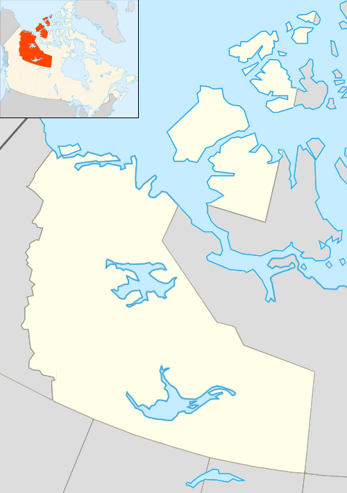
| Territory | Northwest Territories | |
| Region | Dehcho Region | |
| Constituency | Nahendeh | |
| Census division | Region 4 | |
| Settled | 1803 | |
| Village | 1822 | |
| Village (incorporated) | 1 January 1973 | |
| Government | ||
| • Mayor | Darlene Sibbeston | |
| • Senior Administrative Officer | Beth Jumbo | |
| • MLA | Shane Thompson | |
| Area[1] | ||
| • Land | 78.32 km2 (30.24 sq mi) | |
| Elevation | 169 m (554 ft) | |
| Population (2011)[1] | ||
| • Total | 1,238 | |
| • Density | 15.8/km2 (41/sq mi) | |
| Time zone | Mountain (MST) (UTC-7) | |
| • Summer (DST) | MDT (UTC-6) | |
| Canadian Postal code | X0E 0N0 | |
| Area code(s) | 867 | |
| Telephone exchange | 695 | |
| - Living cost | 137.5A | |
| - Food price index | 125.1B | |
| Website | www.fortsimpson.com | |
|
Sources: Department of Municipal and Community Affairs,[2] Prince of Wales Northern Heritage Centre,[3] Canada Flight Supplement[4] ^A 2009 figure based on Edmonton = 100[5] ^B 2010 figure based on Yellowknife = 100[5] | ||

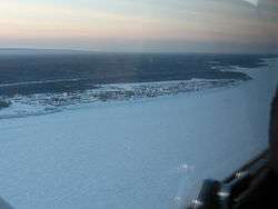
Fort Simpson (Slavey language: Liidli Kue "place where rivers come together") is a village, the only one in the entire territory, in the Dehcho Region of the Northwest Territories, Canada. The community is located on an island at the confluence of the Mackenzie and Liard Rivers. It is approximately 500 km (310 mi) west of Yellowknife. [6] Both rivers were traditionally trade routes for the Hudson's Bay Company and the native Dene people of the area.
Fort Simpson is the regional centre of the Dehcho and is the gateway to the scenic South Nahanni River and the Nahanni National Park Reserve. Fort Simpson can be reached by air, water and road and has full secondary and elementary school service. The Mackenzie Highway was extended to Fort Simpson in 1970-71.
The central section of the community is on an island near the south bank of the Mackenzie River, but industrial areas and rural residential areas are located along the highway as far as the Fort Simpson Airport, just beyond which is the Liard River ferry crossing.
Demographics
| Historical population | ||
|---|---|---|
| Year | Pop. | ±% |
| 1996 | 1,307 | — |
| 1997 | 1,295 | −0.9% |
| 1998 | 1,259 | −2.8% |
| 1999 | 1,266 | +0.6% |
| 2000 | 1,238 | −2.2% |
| 2001 | 1,255 | +1.4% |
| 2002 | 1,258 | +0.2% |
| 2003 | 1,253 | −0.4% |
| 2004 | 1,235 | −1.4% |
| 2005 | 1,242 | +0.6% |
| 2006 | 1,259 | +1.4% |
| 2007 | 1,257 | −0.2% |
| 2008 | 1,262 | +0.4% |
| 2009 | 1,272 | +0.8% |
| 2010 | 1,273 | +0.1% |
| 2011 | 1,269 | −0.3% |
| 2012 | 1,251 | −1.4% |
| Sources: NWT Bureau of Statistics (2001-2012)[5] | ||
Population is 1,238 according to the 2011 Census, an increase of 1.8% over 2006.[1] According to the 2006 Census there were 1,216 people and 820 were Aboriginal. Of these the majority, 715, of the residents are First Nations and the main languages are South Slavey and English.[7] In 2012 the Government of the Northwest Territories reported that the population was 1,251 with an average yearly growth rate of 0.1% from 2001.[5]
History
Fort Simpson was first started as a fur trading site in 1803 then named Fort of the Forks. The Village of Fort Simpson was a permanent settlement in July 1822 when the Hudson's Bay Company constructed a trading post, naming it for George Simpson, then the Governor of Rupert's Land. Until 1910 Fort Simpson was "a company town", with some participation by the Anglican and Roman Catholic Missions. The Dene know it as Liidli Kue, meaning The place where the rivers come together.[8] It was designated a National Historic Site of Canada in 1969.[9]
Pope John Paul II attempted to visit the community in September 1984 as part of his Canadian tour, but was prevented from landing due to fog; in an address over the radio from Yellowknife, he promised to visit in the future. He did so in September 1987 near the end of the tour of the United States, making a side trip to Fort Simpson.
Culture
There are two main annual festivals which occur in Fort Simpson.
The first which is held in March is known as the "Beavertail Jamboree". This is a winter carnival which includes traditional games, snowmobile races, and talent shows.[10]
The other festival is the "Open Sky Festival" which is held annually on or around the July 1 long weekend ("Canada Day"). The Open Sky Festival is a multi-disciplinary arts festival which has occurred annually since 2001. Festival events include musical, theatrical, and other performances as well as traditional Dehcho Dene Crafts, visual arts, new media exhibitions, workshops, and demonstrations. The Open Sky festival is hosted by the Open Sky Creative Society, a multi-disciplinary arts organization serving artists working in the Dehcho region.[11]
The Dene of the community are represented by the Liidli Kue First Nation[12] and the Métis by Fort Simpson Métis Local 52.[13] Both groups belong to the Dehcho First Nations.[14]
Climate
Fort Simpson has a subarctic climate (Köppen Dfc) with long, cold winters and warm but short summers. July temperatures are unusually warm for such northerly areas, which demonstrates the extreme continental nature of the area's climate. However, the heat quickly turns into long and harsh winters when daylight hours turn drastically shorter. Transition seasons are extremely short, and the year is on average dominated by the winter and to a lesser extent, summer. The average monthly temperatures range from −24.2 °C (−11.6 °F) in January to 17.4 °C (63.3 °F) in July. Most of the precipitation falls during the summer months.
The highest temperature ever recorded in Fort Simpson was 36.6 °C (97.9 °F) on 25 July 1994 and 13 July 2014.[15][16] The coldest temperature ever recorded was −56.1 °C (−69 °F) on 1 February 1947.[17]
| Climate data for Fort Simpson Airport, 1981–2010 normals, extremes 1895–present[lower-alpha 1] | |||||||||||||
|---|---|---|---|---|---|---|---|---|---|---|---|---|---|
| Month | Jan | Feb | Mar | Apr | May | Jun | Jul | Aug | Sep | Oct | Nov | Dec | Year |
| Record high °C (°F) | 13.2 (55.8) |
15.6 (60.1) |
16.1 (61) |
25.5 (77.9) |
32.8 (91) |
35.0 (95) |
36.6 (97.9) |
35.4 (95.7) |
30.0 (86) |
25.6 (78.1) |
13.3 (55.9) |
14.5 (58.1) |
36.6 (97.9) |
| Average high °C (°F) | −19.8 (−3.6) |
−15.3 (4.5) |
−6.4 (20.5) |
5.8 (42.4) |
15.0 (59) |
21.8 (71.2) |
23.7 (74.7) |
20.9 (69.6) |
13.7 (56.7) |
1.8 (35.2) |
−11.5 (11.3) |
−17.5 (0.5) |
2.7 (36.9) |
| Daily mean °C (°F) | −24.2 (−11.6) |
−20.6 (−5.1) |
−13.0 (8.6) |
−0.4 (31.3) |
8.7 (47.7) |
15.3 (59.5) |
17.4 (63.3) |
14.7 (58.5) |
8.2 (46.8) |
−2.0 (28.4) |
−15.5 (4.1) |
−21.7 (−7.1) |
−2.8 (27) |
| Average low °C (°F) | −28.5 (−19.3) |
−25.9 (−14.6) |
−19.7 (−3.5) |
−6.7 (19.9) |
2.2 (36) |
8.8 (47.8) |
11.2 (52.2) |
8.5 (47.3) |
2.6 (36.7) |
−5.9 (21.4) |
−19.4 (−2.9) |
−25.9 (−14.6) |
−8.2 (17.2) |
| Record low °C (°F) | −54.4 (−65.9) |
−56.1 (−69) |
−46.7 (−52.1) |
−39.4 (−38.9) |
−22.8 (−9) |
−3.9 (25) |
−1.1 (30) |
−6.1 (21) |
−20.6 (−5.1) |
−27.8 (−18) |
−46.1 (−51) |
−53.3 (−63.9) |
−56.1 (−69) |
| Average precipitation mm (inches) | 18.9 (0.744) |
17.6 (0.693) |
15.4 (0.606) |
17.0 (0.669) |
29.4 (1.157) |
51.3 (2.02) |
61.1 (2.406) |
61.4 (2.417) |
32.2 (1.268) |
39.4 (1.551) |
24.8 (0.976) |
19.1 (0.752) |
387.6 (15.26) |
| Average rainfall mm (inches) | 0.2 (0.008) |
0.0 (0) |
0.1 (0.004) |
2.5 (0.098) |
21.0 (0.827) |
51.2 (2.016) |
61.1 (2.406) |
60.9 (2.398) |
28.5 (1.122) |
12.9 (0.508) |
0.1 (0.004) |
0.0 (0) |
238.6 (9.394) |
| Average snowfall cm (inches) | 27.4 (10.79) |
24.2 (9.53) |
19.0 (7.48) |
17.4 (6.85) |
7.6 (2.99) |
0.1 (0.04) |
0.0 (0) |
0.5 (0.2) |
4.2 (1.65) |
29.0 (11.42) |
33.4 (13.15) |
24.3 (9.57) |
187.0 (73.62) |
| Average precipitation days (≥ 0.2 mm) | 10.9 | 10.6 | 9.4 | 5.6 | 8.8 | 11.3 | 12.1 | 11.0 | 10.6 | 11.8 | 12.0 | 10.7 | 124.7 |
| Average rainy days (≥ 0.2 mm) | 0.2 | 0.1 | 0.2 | 1.0 | 7.1 | 11.3 | 12.1 | 11.0 | 9.8 | 4.2 | 0.2 | 0.0 | 57.1 |
| Average snowy days (≥ 0.2 cm) | 11.6 | 11.7 | 9.8 | 5.0 | 2.3 | 0.0 | 0.0 | 0.1 | 1.4 | 9.2 | 12.7 | 11.3 | 75.1 |
| Average relative humidity (%) | 78.8 | 77.2 | 69.3 | 52.5 | 43.6 | 44.8 | 50.5 | 53.7 | 59.2 | 76.7 | 83.2 | 81.1 | 64.2 |
| Mean monthly sunshine hours | 55.7 | 95.1 | 180.6 | 248.6 | 293.4 | 313.0 | 307.1 | 263.8 | 163.9 | 77.8 | 49.4 | 30.0 | 2,078.3 |
| Percent possible sunshine | 28.5 | 38.0 | 49.6 | 56.3 | 53.8 | 53.7 | 53.3 | 53.4 | 42.0 | 25.0 | 22.8 | 17.7 | 41.2 |
| Source: Environment Canada[15][18][19][20][21][22][23][24][25][26][27][17][28][29][30][16] | |||||||||||||
See also
- List of municipalities in the Northwest Territories
- Fort Simpson Island Airport
- Fort Simpson Island Water Aerodrome
- Fort Simpson/Canadian Helicopters Heliport
- Fort Simpson/(Great Slave) Heliport
References
- 1 2 3 Fort Simpson, VL Northwest Territories (Census subdivision)
- ↑ "NWT Communities - Fort Simpson". Government of the Northwest Territories: Department of Municipal and Community Affairs. Retrieved 13 January 2014.
- ↑ "Northwest Territories Official Community Names and Pronunciation Guide". Prince of Wales Northern Heritage Centre. Yellowknife: Education, Culture and Employment, Government of the Northwest Territories. Archived from the original on 2016-01-13. Retrieved 2016-01-13.
- ↑ Canada Flight Supplement. Effective 0901Z 15 September 2016 to 0901Z 10 November 2016
- 1 2 3 4 Fort Simpson - Statistical Profile at the GNWT
- ↑ "Harper announces expansion of N.W.T. park". CBC News. 2007-08-08. Retrieved 2013-11-01.
- ↑ 2006 Aboriginal Population Profile
- ↑ Fort Simpson Historical Society
- ↑ Fort Simpson National Historic Site of Canada. Directory of Federal Heritage Designations. Parks Canada. Retrieved 11 October 2013.
- ↑ Explore NWT - Beavertail Jamboree
- ↑ Open Sky Creative Society
- ↑ Liidli Kue First Nation
- ↑ Fort Simpson Métis
- ↑ Dehcho First Nations
- 1 2 "Fort Simpson A" (CSV (3069 KB)). Canadian Climate Normals 1981–2010. Environment Canada. Climate ID: 2202101. Retrieved 30 June 2016.
- 1 2 "Daily Data Report for July 2014". Canadian Climate Data. Environment Canada. Climate ID: 2202101. Retrieved 30 June 2016.
- 1 2 "Daily Data Report for February 1947". Canadian Climate Data. Environment Canada. Climate ID: 2202100. Retrieved 30 June 2016.
- ↑ "Daily Data Report for May 1899". Canadian Climate Data. Environment Canada. Climate ID: 2202100. Retrieved 30 June 2016.
- ↑ "Daily Data Report for June 1916". Canadian Climate Data. Environment Canada. Climate ID: 2202100. Retrieved 30 June 2016.
- ↑ "Daily Data Report for August 1922". Canadian Climate Data. Environment Canada. Climate ID: 2202100. Retrieved 30 June 2016.
- ↑ "Daily Data Report for October 1923". Canadian Climate Data. Environment Canada. Climate ID: 2202100. Retrieved 30 June 2016.
- ↑ "Daily Data Report for March 1929". Canadian Climate Data. Environment Canada. Climate ID: 2202100. Retrieved 30 June 2016.
- ↑ "Daily Data Report for December 1933". Canadian Climate Data. Environment Canada. Climate ID: 2202100. Retrieved 30 June 2016.
- ↑ "Daily Data Report for October 1935". Canadian Climate Data. Environment Canada. Climate ID: 2202100. Retrieved 30 June 2016.
- ↑ "Daily Data Report for January 1936". Canadian Climate Data. Environment Canada. Climate ID: 2202100. Retrieved 30 June 2016.
- ↑ "Daily Data Report for February 1938". Canadian Climate Data. Environment Canada. Climate ID: 2202100. Retrieved 30 June 2016.
- ↑ "Daily Data Report for November 1941". Canadian Climate Data. Environment Canada. Climate ID: 2202100. Retrieved 30 June 2016.
- ↑ "Daily Data Report for November 1949". Canadian Climate Data. Environment Canada. Climate ID: 2202100. Retrieved 30 June 2016.
- ↑ "Daily Data Report for April 1954". Canadian Climate Data. Environment Canada. Climate ID: 2202100. Retrieved 30 June 2016.
- ↑ "Daily Data Report for June 1955". Canadian Climate Data. Environment Canada. Climate ID: 2202100. Retrieved 30 June 2016.
- ↑ Climate data was recorded in Fort Simpson from November 1895 to October 1963 and at Fort Simpson Airport from November 1963 to present.
External links
| Wikimedia Commons has media related to Fort Simpson. |
| Census divisions | |||||||||||
|---|---|---|---|---|---|---|---|---|---|---|---|
| Former census divisions | |||||||||||
| Dehcho Region |
| ||||||||||
| Inuvik Region |
| ||||||||||
| North Slave Region |
| ||||||||||
| Sahtu Region |
| ||||||||||
| South Slave Region |
| ||||||||||
| Weather stations (outside of communities) | |||||||||||
| Mine sites |
| ||||||||||
| DEW line and NWS sites |
| ||||||||||
| Hudson's Bay Company trading posts | |||||||||||
| Former districts |
| ||||||||||
| |||||||||||
| Provinces | |
|---|---|
| Territories | |
| Other countries | |
| |