Fort Osage
|
Fort Osage | |
|
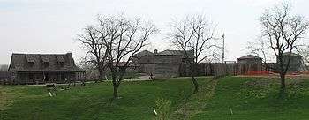
Fort Osage from the west. The "factory" trading post is on the left. | |
  | |
| Location | Sibley, Missouri |
|---|---|
| Coordinates | 39°11′15″N 94°11′32″W / 39.187562°N 94.192121°WCoordinates: 39°11′15″N 94°11′32″W / 39.187562°N 94.192121°W |
| Built | 1808[1] |
| NRHP Reference # | 66000418 |
| Significant dates | |
| Added to NRHP | October 15, 1966[2] |
| Designated NHLD | November 5, 1961[3] |

Fort Osage (also known as Fort Clark or Fort Sibley) was an early 19th century factory trading post system ran by the United States, being located in present day Sibley, Missouri. The Treaty of Fort Clark was signed with certain members of the Osage Nation in 1808 calling for the creation of Fort Osage. It was one of three forts established by the U.S. Army to establish control over the newly acquired Louisiana Purchase territories. Fort Madison in SE Iowa was built to control trade and pacify Native Americans in the Upper Mississippi River region. Fort Belle Fontaine near St. Louis controlled the mouth of the Missouri.[4] The fort ceased operations in the 1820s as the Osage in subsequent treaties ceded the rest of their land in Missouri. A replica of the fort was rebuilt on the site between 1948 and 1961. The Fort Osage school district (including Fort Osage High School), which serves northeast Independence and the surrounding area, was named after it.
Background
During their famous ascent up the Missouri River to find the Northwest Passage, Meriwether Lewis and William Clark noted the spot in June 1804, as they camped for the night just across the river:
"high commanding position, more than 70 feet above high-water mark, and overlooking the river, which is here but of little depth..."[5]
In the same year Pierre Chouteau of the Chouteau fur trading family and an agent for the Osage took Osage chiefs to meet President Thomas Jefferson who promised to build them a trading post. Previously Jefferson promoted his plan of expanding Federal trading posts on the frontier as means to remove the harmful influence of individual merchants by "undersell[ing] private traders" to make them withdraw from borderlands and "earn the good will of the Indians".[6]
Foundation
William Clark led a team in September 1808 back to the site to begin construction of Fort Osage. In November 1808 Pierre Chouteau negotiated the Treaty of Fort Clark with certain members of the Osage Nation, for the fort to be built for the protection of the Osage. The specific terms of the deal noted:[7]
The United States being anxious to promote peace, friendship and intercourse with the Osage tribes, to afford them every assistance in their power, and to protect them from the insults and injuries of other tribes of Indians, situated near the settlements of the white people, have thought proper to build a fort on the right bank of the Missouri, a few miles above the Fire Prairie, and do agree to garrison the same with as many regular troops as the President of the United States may, from time to time, deem necessary for the protection of all orderly, friendly and well disposed Indians of the Great and Little Osage nations, who reside at this place, and who do strictly conform to, and pursue the counsels or admonitions of the President of the United States through his subordinate officers.
In exchange for access to the trading post, the attending Osage agreed to cede all of their lands east of the fort in Louisiana Territory. This effectively left them with a small band of territory on the extreme western border of Missouri. The Great Osage were to receive $1,000 and the Little Osage were to get $500.
Operations
The fort was officially christened "Fort Osage" by Captain Eli Clemson who was in charge of the military garrison at Fort Osage from 1808 until it was evacuated in 1813. It has also been informally referred to as "Fort Clark" in honor of William Clark who was in charge of Indian Affairs. It was one of the first United States military installations in Louisiana Territory and became a major stopping point for visitors traveling the Missouri. Daniel Boone was to visit it in 1814, at the age of 81, while on one of his last hunting trips. Sacagawea and her husband, Toussaint Charbonneau, also stayed at the fort on their way back north to Dakota Territory.
Fort Osage was abandoned in June 1813 during the War of 1812 because it was not considered to be under threat. Since most of the war's fighting was further east and north, the soldiers there were transferred to different locations. After the war the fort was reoccupied in 1815.[8] Fort Osage was for many years a productive location, with the first Factor George C. Sibley reporting prosperous trade with the Osage was due to goods being sold "at prices less than half what the traders extort from them..."[9]
Abandonment
The end of the War of 1812 and the Adams–Onís Treaty removed the threat of Spanish or British backed Indigenous campaigns against the United States throughout the Louisiana Purchase.[9] As the Osage ceded more and more of their land a new trading post at Fort Scott, Kansas was established closer to the ancestral villages near the headwaters of the Osage River near Nevada, Missouri. Fort Osage formally was closed in 1822 but remained a landmark on the Santa Fe Trail and a transit point for supplies going north. However, by 1836 it had been totally obliterated with its pre-cut wood used by local settlers for building houses and barns. The factory house was the last remaining structure, but burned to the ground, leaving only the rock foundation.
Fort Osage National Historic Landmark
Archaeologists rediscovered the foundations of Fort Osage in the 1940s. The station was rebuilt to portray Fort Osage as it was in 1812 by using the preserved surveys created by William Clark and others, making restoration to exact specifications possible. The rebuilt post is known as Fort Osage National Historic Landmark and is owned and operated by the Jackson County Parks and Recreation. It is open to the public Tuesday through Sunday from 9:00am to 4:30pm year round. The Fort Osage Education Center, opened in November 2007, contains exhibits about the site's geology, 19th century natural history, the Hopewell and Osage native cultures, Lewis and Clark, Fort Osage and the Missouri River. In addition, the location has living history demonstrations about early 19th century military and civilian life.
See also
- List of National Historic Landmarks in Missouri
- National Register of Historic Places listings in Jackson County, Missouri
References
- ↑ Fort Osage National Historic Landmark. jacksongov.org
- ↑ National Park Service (2007-01-23). "National Register Information System". National Register of Historic Places. National Park Service.
- ↑ "Fort Osage". National Historic Landmark summary listing. National Park Service. Retrieved 2008-06-28.
- ↑ Prucha, Francis P. (1964) A Guide to the Military Posts of the United States 1789–1895. State Historical Society of Wisconsin, Madison.; also Prucha, Francis P. (1969) The Sword of the Republic: The United States Army on the Frontier 1783–1846. Macmillan, New York.
- ↑ Fort Osage – National Park Service. Cr.nps.gov. Retrieved on 2013-08-28.
- ↑ Jefferson, Thomas, "Trade," 18 Jan. 1803, American State Papers: Indian Affairs (Washington, D.C., 1832), Vol. 1: 684.
- ↑ Treaty of Fort Clark. Digital.library.okstate.edu. Retrieved on 2013-08-28.
- ↑ Rodriguez, Junius P. (2002) The Louisiana Purchase: A Historical and Geographical Encyclopedia, Clio, Santa Barbara, CA, p. 270, ISBN 157607188X.
- 1 2 Isenberg, Andrew C. "The Market Revolution in the Borderlands: George Champlin Sibley in Missouri and New Mexico, 1808-1826." Journal of the Early Republic 21, No. 3 (2001), pp. 445-465.
External links
| Topics | |
|---|---|
| Lists by states |
|
| Lists by insular areas | |
| Lists by associated states | |
| Other areas | |
| |