Fort Churchill State Historic Park
|
Fort Churchill | |
|
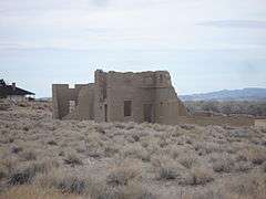
Ruins at Fort Churchill State Historic Park | |
 | |
| Location | Lyon County, Nevada, USA |
|---|---|
| Nearest city | Silver Springs, Nevada |
| Coordinates | 39°17′33″N 119°16′14″W / 39.29250°N 119.27056°WCoordinates: 39°17′33″N 119°16′14″W / 39.29250°N 119.27056°W |
| Built | 1860 |
| Architect | Captain Joseph Stewart, Captain F.F. Flint |
| NRHP Reference # | 66000456 |
| Significant dates | |
| Added to NRHP | October 15, 1966[1] |
| Designated NHL | November 5, 1961[2] |

Fort Churchill State Historic Park is a state park of Nevada, USA, preserving the remains of a United States Army fort and a waystation on the Pony Express and Central Overland Routes dating back to the 1860s. A 1994 addition forms a corridor along the Carson River. The park is in Lyon County south of the town of Silver Springs. Fort Churchill is one of seven National Historic Landmarks in Nevada. The site is one end of the historic Fort Churchill and Sand Springs Toll Road. It is located on U.S. Route 95 Alternate, 8 miles (13 km) south of U.S. Route 50.
Fort Churchill
Fort history
In 1860 a band of Paiutes and Bannocks attacked Williams Station along the Carson River in retaliation for the kidnap and rape of two young Paiute girls by the proprietors of the station.[3] In retaliation a small group of volunteer soldiers and vigilantes led by Maj. William Ormsby attacked the Native Americans, starting the so-called Pyramid Lake War. Ormsby's force was defeated and in response Colonel John C. Hays and Captain Joseph Stewart led a larger force of volunteers and U.S. Regulars to defeat the Natives at the Second Battle of Pyramid Lake.[4]
Captain Stewart, leading the Regular contingent, afterward established a permanent U.S. Army fort along the Carson River near the location of where the hostilities began at Williams Station. The post was named Fort Churchill for Sylvester Churchill, Inspector General of the U.S. Army. Construction on the fort began on July 20, 1860 and was completed in 1861. Built to provide protection for early settlers and the mail route along the Pony Express, the fort became an important supply depot for the Union Army during the American Civil War. Average strength during this time was 200 soldiers, but the post was abandoned in 1869 shortly after the conclusion of the Civil War. The abandoned buildings were sold at an auction for $750 after the state of Nevada declined to take possession of the property.[5]
State park
On October 6, 1932, the state took control of the 200 acres (81 ha) but two years later deeded the property to a local chapter of the Daughters of the American Revolution. With aid from the National Park Service, the fort ruins were partially restored to a state of arrested decay, and the Civilian Conservation Corps built the current visitor center.
On February 16, 1961, the fort and surrounding property were once again acquired by the state for the proclamation of a state historic site;[5] it was declared a National Historic Landmark the same year.[2][6]
Carson River Ranches
In 1994, the state park service acquired 3,200 acres (1,300 ha) along the Carson River, east of the fort and Buckland Station. This corridor connects Fort Churchill with Lahontan State Recreation Area and provides habitat for diverse plants and wildlife. It is popular with campers, hikers, birdwatchers, canoeists, hunters and equestrians.[5]
Buckland Station
Samuel S. Buckland came to the area in 1859 to begin ranching. His ranch served as an important way station along the Central Overland Route. The Pony Express also had a change of mounts at the ranch. When Fort Churchill was abandoned and being dismantled, Buckland salvaged materials to build the current two-story building seen today. The state park added this building to the Fort Churchill State Historic Site in 1997.
Park facilities
The Visitor Center has exhibits on the history of Fort Churchill, Native Americans that inhabited the area, and natural features of the surrounding countryside.[5]
Within the Fort Churchill unit is a 20-site campground situated along the Carson River within a grove of cottonwood trees with an adjacent group-camp and day-use picnic areas. There is a primitive camp further along the Carson River in the Carson River Ranches unit.
Hiking trails include a self-guided trail around the fort ruins with interpretive signs explaining each of the buildings. The Orchard Trail runs along the Carson River from the campground to Buckland Station. A continuation of this trail runs the length of the Carson River in the Carson River Ranches unit.
Twice a year the Nevada Civil War Volunteers put on a civil war encampment at Fort Churchill.
References
- ↑ National Park Service (2007-01-23). "National Register Information System". National Register of Historic Places. National Park Service.
- 1 2 "Fort Churchill". National Historic Landmark summary listing. National Park Service. Retrieved 2007-10-03.
- ↑ Hopkins, Sarah Winnemucca (1883). Life Among the Piutes: Their Wrongs and Claims. New York: G.P. Putman's Sons.
- ↑ Edwars, Jerome (2011-01-18). "Pyramid Lake War". Online Nevada Encyclopedia. Nevada Humanities. Retrieved 2012-02-07.
- 1 2 3 4 "Fort Churchill State Historic Site". Nevada State Parks. Retrieved 2012-02-07.
- ↑ Marilynn Larew (January 1978). "National Register of Historic Places Inventory-Nomination:" (pdf). National Park Service.. Accompanying 2 photos, exterior, from 1966. (452 KiB)
External links
| Wikimedia Commons has media related to Fort Churchill State Historic Park. |
- Fort Churchill State Historic Park Nevada State Parks
- Historic American Buildings Survey (HABS) No. NV-10-17, "Fort Churchill (Ruins), U.S. 95-A, Old Buckland Ranch, Churchill vicinity, Lyon County, NV", 6 photos