Formoso do Araguaia
| Formoso do Araguaia | ||
|---|---|---|
| Municipality | ||
| The Municipality of Formoso do Araguaia | ||
|
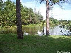
A lake in Formoso do Araguaia | ||
| ||
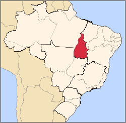
 Location of Formoso do Araguaia in the State of Tocantins | ||
| Coordinates: 11°47′49″S 49°31′44″W / 11.79694°S 49.52889°WCoordinates: 11°47′49″S 49°31′44″W / 11.79694°S 49.52889°W | ||
| Country |
| |
| Region | North | |
| State |
| |
| Founded | October 1, 1963 | |
| Government | ||
| • Mayor | Pedro Rezende (PTB) | |
| Area | ||
| • Total | 13,423.256 km2 (5,182.748 sq mi) | |
| Elevation | 240 m (790 ft) | |
| Population (2012) | ||
| • Total | 18,369 | |
| • Density | 1.4/km2 (3.5/sq mi) | |
| [1] | ||
| Time zone | UTC-3 (UTC-3) | |
| • Summer (DST) | UTC-2 (UTC-2) | |
| HDI (2000) | 0.710 – medium[2] | |
Formoso do Araguaia is a municipality in the state of Tocantins in the Northern region of Brazil.[3][4] It is the largest municipality by area in that state.
See also
References
- ↑ "2012 Populational Estimate" (PDF). Censo Populacional 2012. Instituto Brasileiro de Geografia e Estatística (IBGE). July 2012. Retrieved September 10, 2012.
- ↑ - UNDP
- ↑ "Divisão Territorial do Brasil" (in Portuguese). Divisão Territorial do Brasil e Limites Territoriais, Instituto Brasileiro de Geografia e Estatística (IBGE). July 1, 2008. Retrieved December 17, 2009.
- ↑ "Produto Interno Bruto dos Municípios 2002-2005" (PDF) (in Portuguese). Instituto Brasileiro de Geografia e Estatística (IBGE). December 19, 2007. Retrieved December 17, 2009.
This article is issued from Wikipedia - version of the 5/8/2016. The text is available under the Creative Commons Attribution/Share Alike but additional terms may apply for the media files.