Forksville, Pennsylvania
| Forksville, Pennsylvania | ||
|---|---|---|
| Borough | ||
|
Forksville Covered Bridge, built 1850, over Loyalsock Creek with the Forksville General Store behind | ||
| ||
 Map of Sullivan County, Pennsylvania, highlighting Forksville | ||
 Forksville, Pennsylvania Location within the state of Pennsylvania | ||
| Coordinates: 41°29′32″N 76°36′19″W / 41.49222°N 76.60528°WCoordinates: 41°29′32″N 76°36′19″W / 41.49222°N 76.60528°W | ||
| Country | United States | |
| State | Pennsylvania | |
| County | Sullivan | |
| Settled | 1794 | |
| Incorporated (borough) | 1880 | |
| Area | ||
| • Total | 1.5 sq mi (3.9 km2) | |
| Elevation | 1,001 ft (305 m) | |
| Population (2010) | ||
| • Total | 145 | |
| • Density | 96.6/sq mi (37.8/km2) | |
| Time zone | Eastern (EST) | |
| • Summer (DST) | EDT (UTC) | |
| Zip code | 18616 | |
| Area code(s) | 570 | |

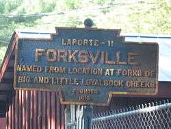
Forksville is a borough in Sullivan County, Pennsylvania, United States. The population was 145 at the 2010 census. It is the home of the 150-year-old Forksville General Store, down the road from the Sullivan County Fairgrounds, and near Worlds End State Park. The name comes from the confluence of Little Loyalsock Creek and Loyalsock Creek within the borough.[1]
History
The Forksville Covered Bridge was added to the National Register of Historic Places in 1980.[2] Forksville was first permanently settled by William Molyneaux, John Warren and Powell Bird. A sawmill was built in the Forksville area in 1810. Forksville was formed from Forks Township in 1880.[1]
Geography
According to the United States Census Bureau, the borough has a total area of 1.5 square miles (3.9 km2), all of it land.
Demographics
| Historical population | |||
|---|---|---|---|
| Census | Pop. | %± | |
| 1880 | 108 | — | |
| 1890 | 191 | 76.9% | |
| 1900 | 152 | −20.4% | |
| 1910 | 109 | −28.3% | |
| 1920 | 94 | −13.8% | |
| 1930 | 105 | 11.7% | |
| 1940 | 108 | 2.9% | |
| 1950 | 145 | 34.3% | |
| 1960 | 131 | −9.7% | |
| 1970 | 158 | 20.6% | |
| 1980 | 137 | −13.3% | |
| 1990 | 160 | 16.8% | |
| 2000 | 147 | −8.1% | |
| 2010 | 145 | −1.4% | |
| Est. 2015 | 144 | [3] | −0.7% |
| Sources:[4][5][6] | |||
As of the census of 2010,[7] there were 145 people, 67 households, and 42 families residing in the borough. The population density was 96.6 people per square mile (37.8/km²). There were 94 housing units at an average density of 62.4 per square mile (24.0/km²). The racial makeup of the borough was 94.5% White, 2.1% Black, 2.8% Native American, and 0.6% two or more races.
There were 67 households out of which 19.4% had children under the age of 18 living with them, 49.3% were married couples living together, 10.4% had a female householder with no husband present, and 37.3% were non-families. 31.3% of all households were made up of individuals and 16.4% had someone living alone who was 65 years of age or older. The average household size was 2.16 and the average family size was 2.60.

In the borough the population was spread out with 13.1% under the age of 18, 66.2% from 18 to 64, and 20.7% who were 65 years of age or older. The median age was 45.5 years.
The median income for a household in the borough was $26,625, and the median income for a family was $31,563. Males had a median income of $26,563 versus $25,417 for females. The per capita income for the borough was $13,943. There were 19.1% of families and 22.1% of the population living below the poverty line, including 36.4% of under eighteens and none of those over 64.
Forksville Borough is protected by the Forksville Volunteer Fire Company, which operates a 1918 Ford Pumper and an 1900 Hand Drawn-Hand Operated Pumper, has about a dozen volunteers.
Notable people
Red Grange, College and Pro Football Hall of Famer, was born in Forksville before moving to Wheaton, Illinois, at age 5. Grange is widely considered to be the first superstar of the National Football League.
References
- 1 2 http://www.livingplaces.com/PA/Sullivan_County/Forksville_Borough.html
- ↑ National Park Service (2010-07-09). "National Register Information System". National Register of Historic Places. National Park Service.
- ↑ "Annual Estimates of the Resident Population for Incorporated Places: April 1, 2010 to July 1, 2015". Retrieved July 2, 2016.
- ↑ "Census of Population and Housing". U.S. Census Bureau. Retrieved 11 December 2013.
- ↑ "American FactFinder". United States Census Bureau. Retrieved 2008-01-31.
- ↑ "Incorporated Places and Minor Civil Divisions Datasets: Subcounty Resident Population Estimates: April 1, 2010 to July 1, 2012". Population Estimates. U.S. Census Bureau. Retrieved 11 December 2013.
- ↑ "American FactFinder". United States Census Bureau. Retrieved 2011-05-14.
External links
| Wikimedia Commons has media related to Forksville, Pennsylvania. |
Municipalities and communities of Sullivan County, Pennsylvania, United States | ||
|---|---|---|
| Boroughs | 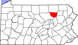 | |
| Townships | ||
| Unincorporated communities |
| |
| Ghost town | ||