Forest Hills, Pennsylvania
| Forest Hills | ||
|---|---|---|
| Borough | ||
|
| ||
| ||
| Nickname(s): Tree City, USA | ||
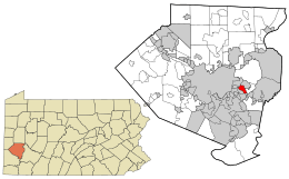 Location in Allegheny County and the state of Pennsylvania | ||
| Coordinates: 40°25′19″N 79°51′7″W / 40.42194°N 79.85194°WCoordinates: 40°25′19″N 79°51′7″W / 40.42194°N 79.85194°W | ||
| Country | United States | |
| State | Pennsylvania | |
| County | Allegheny | |
| School DIstrict | Woodland Hills | |
| Founded | July 29, 1919 | |
| Named for | Forest Hills, Queens | |
| Government[1] | ||
| • Type | Mayor-Council | |
| • Mayor | Frank Porco | |
| • Council |
List:
| |
| • Manager | Steve Morus | |
| Area | ||
| • Total | 1.6 sq mi (4 km2) | |
| • Land | 1.6 sq mi (4 km2) | |
| • Water | 0 sq mi (0 km2) | |
| Population (2010) | ||
| • Total | 6,518 | |
| • Density | 4,100/sq mi (1,600/km2) | |
| Time zone | Eastern (EST) (UTC-5) | |
| • Summer (DST) | EDT (UTC-4) | |
| Zip Code | 15221 | |
| Area code(s) | 412, 878 | |
| Website | http://foresthillspa.org | |
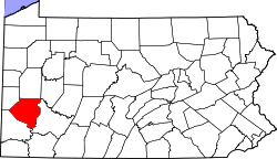
Forest Hills is a borough in Allegheny County, Pennsylvania, United States. The population was 6,518 at the 2010 census, as compared to 6,831 in 2000, and 7,335 in 1990.
The borough was named after Forest Hills, Queens.[2]
Geography
Forest Hills is located at 40°25′19″N 79°51′7″W / 40.42194°N 79.85194°W (40.421918, -79.851872).[3] According to the United States Census Bureau, the borough has a total area of 1.6 square miles (4.1 km2), all of it land.
Forest Hills is bordered by the following municipalities: Braddock Hills, North Braddock, Chalfant, Churchill, Wilkins Township, Wilkinsburg. These municipalities, along with East Pittsburgh, Edgewood, Rankin, Swissvale, and Turtle Creek, make up the Woodland Hills School District.[4]
Extra-borough Elected Representatives
Landmarks
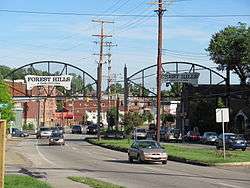
Forest Hills is located along the Route 30 portion of the Lincoln Highway, which, along with Greensburg Pike, serves as a main artery of the borough. Near the eastern border with Chalfant until 2015 was an out-of-use, five-million-volt[6] Van de Graaff generator and particle accelerator known as the Westinghouse Atom Smasher. The Atom Smasher operated until 1958 and was designated as a historic landmark.
Forest Hills is known for its many recreational and family oriented activities. Forest Hills boasts several parks: Forest Hills main Park and Arboretum, Ryan Glenn, Koch, Avenue L Park and Arboretum, and Bright Park. The summer attraction is its pool, which offers residents and their guests a place to keep cool. Several of the facilities offer affordable rentals throughout the year. There are several leagues available to the residents and their families including: baseball, soccer, basketball, swimming, synchronized swimming and tennis. Adults have several options as well including yoga, aerobics, pool classes, lap swimming, scrap-booking, and various other activities. Seniors can enjoy a lunch and activities at the senior center.
Demographics
| Historical population | |||
|---|---|---|---|
| Census | Pop. | %± | |
| 1930 | 4,549 | — | |
| 1940 | 5,248 | 15.4% | |
| 1950 | 6,301 | 20.1% | |
| 1960 | 8,796 | 39.6% | |
| 1970 | 9,561 | 8.7% | |
| 1980 | 8,198 | −14.3% | |
| 1990 | 7,335 | −10.5% | |
| 2000 | 6,831 | −6.9% | |
| 2010 | 6,518 | −4.6% | |
| Est. 2015 | 6,443 | [7] | −1.2% |
| Sources:[8][9][10][11][12] | |||
As of the census[13] of 2010, there were 6,518 people, 3,099 households, and 1,807 families residing in the borough. The population density was 4,073.8 people per square mile (1,572.9/km²). There were 3,304 housing units at an average density of 2,065.0 per square mile (797.3/km²). The racial makeup of the borough was 87.68% White, 9.14% African American, 0.09% Native American, 1.18% Asian, 0.02% Pacific Islander, 0.40% from other races, and 1.49% from two or more races. Hispanic or Latino of any race were 1.32% of the population.
There were 3,099 households, out of which 21.1% had children under the age of 18 living with them, 45.4% were married couples living together, 9.5% had a female householder with no husband present, and 41.7% were non-families. 35.8% of all households were made up of individuals, and 31.0% had someone living alone who was 65 years of age or older. The average household size was 2.10 and the average family size was 2.74.
In the borough the population was spread out, with 18.7% under the age of 20, 4.3% from 20 to 24, 24.1% from 25 to 44, 33.2% from 45 to 64, and 19.7% who were 65 years of age or older. The median age was 47.5 years. For every 100 females there were 87.3 males. For every 100 females age 18 and over, there were 82.6 males.
In 2000, the median income for a household in the borough was $44,922, and the median income for a family was $56,199. Males had a median income of $42,903 versus $31,103 for females. The per capita income for the borough was $26,505. About 4.7% of families and 5.6% of the population were below the poverty line, including 8.2% of those under age 18 and 2.7% of those age 65 or over.
References
- ↑ Forest Hills Elected Officials l
- ↑ Porter, Thomas J. Jr. (May 10, 1984). "Town names carry a little bit of history". Pittsburgh Post-Gazette. p. 1. Retrieved 26 May 2015.
- ↑ "US Gazetteer files: 2010, 2000, and 1990". United States Census Bureau. 2011-02-12. Retrieved 2011-04-23.
- ↑ Woodland Hills School District
- ↑ Allegheny County Council Districts by Municipality
- ↑ Atom Smasher (Circa 1937) - Odd-Shaped Buildings on Waymarking.com
- ↑ "Annual Estimates of the Resident Population for Incorporated Places: April 1, 2010 to July 1, 2015". Retrieved July 2, 2016.
- ↑ "Number and Distribution of Inhabitants:Pennsylvania-Tennessee" (PDF). Fifteenth Census. U.S. Census Bureau.
- ↑ "Number of Inhabitants: Pennsylvania" (PDF). 18th Census of the United States. U.S. Census Bureau. Retrieved 22 November 2013.
- ↑ "Pennsylvania: Population and Housing Unit Counts" (PDF). U.S. Census Bureau. Retrieved 22 November 2013.
- ↑ "American FactFinder". United States Census Bureau. Retrieved 2008-01-31.
- ↑ "Annual Estimates of the Resident Population". U.S. Census Bureau. Retrieved 22 November 2013.
- ↑ "Census Bureau Fact Finder". United States Census Bureau. Retrieved 2011-05-21.
External links
- Borough of Forest Hills official website
- Local / Neighborhoods East (Pittsburgh Post-Gazette)
| Counties |  Map of the Pittsburgh Tri-State with green counties in the metropolitan area and yellow counties in the combined area. | |
|---|---|---|
| Major cities | ||
| Cities and towns 15k-50k (in 2010) | ||
| Airports | ||
| Topics | ||
| ||