Foothills Regional Airport
| Foothills Regional Airport | |||||||||||
|---|---|---|---|---|---|---|---|---|---|---|---|
 | |||||||||||
| IATA: MRN – ICAO: KMRN – FAA LID: MRN | |||||||||||
| Summary | |||||||||||
| Airport type | Public | ||||||||||
| Owner | Foothills Regional Airport Authority | ||||||||||
| Serves | Morganton, North Carolina, US | ||||||||||
| Elevation AMSL | 1,270 ft / 387 m | ||||||||||
| Coordinates | 35°49′13″N 081°36′41″W / 35.82028°N 81.61139°W | ||||||||||
| Runways | |||||||||||
| |||||||||||
| Statistics (2005) | |||||||||||
| |||||||||||
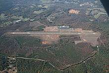
Foothills Regional Airport (formerly Morganton-Lenoir Airport) (IATA: MRN, ICAO: KMRN, FAA LID: MRN) is a public airport located six miles northeast of the City of Morganton, NC. It is owned by the Foothills Regional Airport Authority.[1]
Facilities and Aircraft
The Foothills Regional Airport covers an area of 1,170 acres (473 ha) and contains one grooved asphalt paved runway: 3/21 measuring 5,500 ft × 75 ft (1,676 m × 23 m). For the 12-month period ending August 31, 2005, the airport had 17,000 aircraft operations, an average of 46 per day: 97% general aviation and 3% military. There were 73 aircraft based on the field at that time.[1]
References
This article is issued from Wikipedia - version of the 8/1/2015. The text is available under the Creative Commons Attribution/Share Alike but additional terms may apply for the media files.