Fontibón
| Fontibón | |
|---|---|
| Locality of Bogotá | |
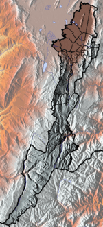
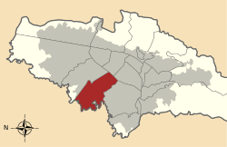 Location of the locality in the city of Bogotá | |
 Location of the locality in the Capital District of Bogotá | |
| Country |
|
| City | Bogotá D.C. |
| Neighbourhoods | |
| Area | |
| • Total | 33.28 km2 (12.85 sq mi) |
| Elevation | 2,600 m (8,500 ft) |
| Population (2007)[1] | |
| • Total | 317,179 |
| • Density | 9,500/km2 (25,000/sq mi) |
| Time zone | Colombia Standard Time (UTC-5) |
| Website | Official website |
Fontibon is a former municipality located at the westernmost side of Bogotá, Colombia.
Etymology
The origin of the city's name can be traced to the Muisca ruler cacique Huintiva or Hyntiba (meaning "powerful cacique") and the mutation of the word to its present spelling, being this among other names such as Ontibon and Hontibón.[2]
History
Fontibón was part of the southern Muisca Confederation in the times before the Spanish conquest. It was incorporated into the newly formed capital district of Bogotá on December 17, 1954.[3] Fontibon was the gate to the current city of Bogotá also known as Santa Fe de Bogotá, for conquistador Gonzalo Jimenez de Quesada and his fellow expeditioners.
The city was cradle to the residence of Peter Claver. Little by little the community became one of the most idolizing and religious. The city started to expand, and in the sixteenth century it was divided into 22 "capitanias".
Fontibon's original maps constitute one of Colombia's oldest documents.
In the year 1956, Fontibon was merged with Bogota, losing its status as "associate town".
Economy
The neighborhood has the headquarters of SATENA.[4][5][6][7]
Monuments
- The Fontibon Cathedral.
- The San Antonio Bridge.
Transportation
The city is still far away from Bogota's major mass transport system - the TransMilenio. Fontibon's main highway leads to Medellín.
References
- ↑ (Spanish) Population 2007 - DANE
- ↑ (Spanish) Etymology localities of Bogotá
- ↑ (Spanish) History Fontibón
- ↑ "Oficinas." SATENA. Retrieved on January 20, 2011. "Oficina Principal Av. El Dorado No. 103 - 08, entrada 1, interior 11."
- ↑ "Mecanismos de Control." SATENA. Retrieved on January 20, 2011. "Oficina Principal: Avenida Eldorado Entrada 1, Interior 11."
- ↑ "Satena Aerolíneas." City of Bogota. Retrieved on January 20, 2011.
- ↑ "Satena." City of Bogota. Retrieved on January 20, 2011. "Avenida El Dorado # 103 - 08."
External links
 | Administrative subdivision in 19 localities |  | |
|---|---|---|---|
| Metropolitan Area | |||
| Geography | |||
| |||
Coordinates: 4°40′43″N 74°08′28″W / 4.67861°N 74.14111°W