Folly Pier Waterworks

Folly Pier Waterworks was a Victorian waterworks on the Isle of Portland, Dorset, England. The building was situated near the coastline of East Weares, the east side of Portland, and sat below HM Prison Portland, which it supplied water for. The waterwork remains are of local historical interest for its association with the Portland Convict Establishment. The waterworks today only shows remains of the reservoirs foundations and walls.
The site is found close to various old historic relics such as the East Weares Rifle Range, Folly Pier, King's Pier, the Salt Pans and Little Beach. The East Weares area, including the site of the Folly Pier Waterworks, has been labelled a Site of Special Scientific Interest (SSSI), largely due to the scrub and wildlife being of high nature conservation value.[1]
History
With the construction of the breakwaters for Portland Harbour, between 1849–72, as well as the various 19th-century fortifications including the Verne Citadel, HM Prison Portland was established in 1848 to provide convict labour for these works.[2] The Admiralty realised the current water supply on the island was not sufficient for their needs, and they tasked Chief Engineer John Coode to build Folly Pier Waterworks and its large reservoir at East Weares, along with a pumping station on the clifftop at Cheyne.[3][4]
Folly Pier Waterworks' primary role was to ensure the prison was supplied, and in doing so the waterworks acted as an intermediary by receiving and managing water from Cheyne's pumping station.[5] The waterworks was built with separate reservoir tanks to hold rainwater and seawater, and these would both be pumped up to the prison.[6] The waterworks was named after Folly Pier, and this pier once transported stone by sea from the nearby quarries.[7]
The site is marked on the Ordnance Survey maps of 1891 and 1903 as "Folly Pier Water Works (Prison Department)".[4] The waterworks was closed due to an outbreak of typhoid which killed several prisoners who drank the water.[7] In 1921 the Portland convict establishment was converted into a Borstal, and during the late 1920s and 1930s, the remaining ruins of the reservoir tanks were used as swimming pools for Borstal Boys, despite the risk of Typhoid.[8][9] However, in 1933, one of the Borstal Boys drowned during a swimming event, and this caused all swimming to be banned from the reservoirs. A swimming pool within the prison grounds was later installed.[10]
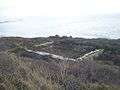
Nature has now nearly reclaimed her ground in East Weares as overgrown brambles surround the foundations. Beneath the foliage lie the low broken stone foundations and walls. The majority of the site have either been demolished or have collapsed in the intervening years. Only the stone foundations of some structures and the reservoirs are understood to survive under the overgrowth. One of the remaining reservoirs acts now as a pond.[7]
Access
The waterworks foundations can be reached via an unofficial pathway veering off the official coastal path of the East Weares area. A similar pathway further south links to the Salt Pans of East Weares.
References
- ↑ "File:East Weares - Portland Goats Sign - Portland, Dorset.JPG - Wikimedia Commons". Commons.wikimedia.org. Retrieved 2013-12-04.
- ↑ http://www.pbenyon.plus.com/Portland/PYB/Chronology.html
- ↑ Morris, Stuart (1985). Portland, an Illustrated History. Dorset: The Dovecote Press, Wimborne, Dorset. pp. 87, 88. ISBN 0-946159-34-3.
- 1 2 http://www.heritagegateway.org.uk/Gateway/Results_Single.aspx?uid=1421514&resourceID=7
- ↑ http://www.southampton.ac.uk/~imw/Portland-Isle-Geological-Introduction.htm
- ↑ Morris, Stuart (2006). Portland Then and Now. Dovecote Press. pp. Photo 10 of Portland Harbour Chapter. ISBN 978-1904349488.
- 1 2 3 "East Weares Rifle Range and Waterworks, Portland, Dorset". Geoffkirby.co.uk. Retrieved 2013-12-04.
- ↑ Legg, D. R. G. (2000). Portland Prison Illustrated. Sprint Signs and Graphics, Weymouth. p. 46.
- ↑ Portland Prison illustrated 1848-2000 - D. R. G. Legg - Google Books. Books.google.co.uk. Retrieved 2013-12-04.
- ↑ Grove Prison Museum - Official Museum Guide. Grove Prison Museum. 2014. p. 20.
Gallery
-
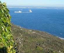
The waterworks from the coast path of East Weares.
-

Another large section of the remains.
-

The centre area of the remains.
-

Reeds growing in a pond-like area of the ruins.
-

A remaining wall.
Coordinates: 50°33′13″N 2°25′07″W / 50.5535°N 2.4187°W