Floods in the United States: 2001–present
Floods in the United States: 2001–present is a list of flood events which were of significant impact to the country since 2001, inclusive. Floods are generally caused by excessive rainfall, excessive snowmelt, storm surge from hurricanes, and dam failure.
Decade of the 2000s

Tropical Storm Allison floods in Louisiana and Texas – June 2001
The remains of the tropical cyclone sat and spun over eastern Texas for several days before moving eastward just inland of the Gulf coast. Heavy rains fell along the western Gulf coast that week, with storm totals of near 940 mm (37 in) near Houston and 1041mm (41 in) west of Beaumont. Damage from the storm was estimated near US$6 billion (2001 dollars), and 41 perished from the flood.[1]
Los Angeles County Flood of 2005
Hurricane Katrina (2005) storm surge – Louisiana and Mississippi

A large category 3 hurricane at landfall along the southeast tip of Louisiana, strong northerly flow behind Katrina while weakening to category 1 strength caused breaks and failures in the levees that protected the lower Ninth Ward and along other canals in New Orleans, flooding 80 percent of the city for nearly a month. The mouth of the Mississippi River saw breaks in its levee system due to storm surge. In Mississippi, a massive storm surge destroyed most structures along the coast including floating casinos, and preliminary figures show that the storm surge was higher than in Hurricane Camille of 1969.[2] There were 1,836 fatalities, mostly from flooding.
Mid-Atlantic and New England Flood – October 2005
The combination of a moisture fetch set up by Subtropical Depression 22 and Tropical Storm Tammy, as well as an additional tropical disturbance which rode up a stationary frontal zone, set up excessive rains from coastal sections of the Mid-Atlantic states through southern New England. In New Hampshire, the Monadnock region was affected, with Alstead among the hardest hit as 300 mm (12 in) of rain fell within 30 hours, allowing this month to be the wettest in the history of the Granite State. It was considered a once in 500-year flood event.[3]
Ka Loko Reservoir – March 2006
Prolonged rains fell across Hawaii between February 19 and April 2, 2006 as upper cyclones kept closing off northwest of the archipelago, virtually eliminating their normal trade winds, and bringing some of the wettest conditions seen in the state since March 1951. Four of the cyclones were kona lows. The heavy rain event of March 1 to 3 brought severe flooding to the east-facing slopes of the Koolau Range in Oahu, with 571 mm (22.47 in) falling in two days at Punalu'u. During the next rain event from March 8 to 11, many of the larger islands received significant amounts of rainfall. Flash flooding occurred in Maakua Stream, and severe inundation affected communities from Laie to Kahana. As much as 356 mm (14 in) of rain fell over north Kauai, forcing the closure of Kuhio Highway at the Hanalei Bridge for the second time in 24 hours. 150–255 mm (6–10 in)of rain fell upon the southeast-facing slopes of the Big Island causing numerous road closures in Hilo. North and east Kauai received 200–300 mm (8–12 in) of rain over a 3-day period. Mount Waialeale recorded over 711 mm (28 in) during this 4-day period. The Kauai Marriott Resort suffered significant damage due to the overflow of Keonaawanui Stream during the early morning hours of March 11. The third significant rain event between March 13 and March 18 was too much for Ka Loko Dam in northeast Kauai, which failed in the early morning of March 14. The wall of water swept away homes and structures and resulted in 3 confirmed deaths and 4 persons missing. Repeated thunderstorms and heavy rains produced numerous road closures from flooding and inundated many properties.[4]
Mid-Atlantic Flood – June 2006
A stalled frontal boundary, a tropical connection, and a developing tropical disturbance led to heavy rains across the Mid-Atlantic and Northeast, particularly in central Maryland and Pennsylvania during late June. Rainfall amounts ranged up to 430 mm (17 in) during the several days of heavy rain. There was threat of dam failure around an earthen dam around Lake Needwood in eastern Montgomery County, Maryland, due to the deluge.
Western Gulf Coast flood – October 2006

A trio of heavy rainfall events, on October 14–17, October 18–19,[5] and again from October 26–27 set the stage for moderate to significant flooding across portions of eastern Texas, Louisiana, as well as portions of Arkansas and Mississippi.[6] This was the wettest spell for the region since T.S. Allison of the 1989 Atlantic hurricane season.[7] Two of these events were fed by tropical cyclones from the 2006 Pacific Hurricane Season, Norman and Paul, which affected western Mexico. Each rainfall event led to localized maxima in excess of 250 mm (10 in), and helped break a dry spell across the region. Localized totals ranged up to 711 mm (28 in) near Kountze, Texas during the 13-day period from October 14 through October 27.
Washington State Flood – November 2006
Severe flooding in Washington state closed Mount Rainier National Park and damaged several mountain towns, including North Bend.
2007 Midwest flooding – August 2007
A stalled frontal boundary stretching from Iowa to Ohio was the focus for several rounds of heavy rainfall resulting in flash flooding the week August 18 – August 25, 2007. Minnesota, Iowa, Wisconsin, Illinois, Indiana and Ohio were the states hardest hit. Across the six states, 18 counties were declared federal disaster areas. Numerous rainfall records, both for most rain in the month of August as well as 24-hour rainfall totals were recorded. Over 457 mm (18 in) of rain was recorded in some locations during this week. At least $100 million in damages has been reported in Minnesota and Wisconsin alone, and 18 people were killed.
2007 Oregon and Washington floods – December 2007
Flooding occurred in Oregon and Washington along with high winds. Interstate 5 was both closed and damaged.
2008 Midwest flooding – Spring 2008
Flooding occurred in the midwest part of the United States.
June 2008 Midwest Flood

Extensive flooding is occurring or has occurred on the Wabash, White, Zumbro, Kickapoo, Wisconsin, Baraboo, Cedar, Crawfish, Fox, Iowa, Rock, and Des Moines rivers, as well as the upper Mississippi River, leading to extensive flooding in Iowa, Wisconsin, Indiana, Minnesota, Michigan, and Missouri.
July–August 2008 Alaska Flood
Spring 2009 Red River Flood
In 2009, a record flood caused extensive damages along the Red River of the North, affecting the areas of Fargo-Moorhead, Wahpeton-Breckenridge, and Grand Forks between the Minnesota–North Dakota border, as well as Winnipeg and its surroundings in Manitoba, Canada.
September 2009 Southern Flood
A major rain event from September 16 through 22, which brought over ten inches of rain to the Atlanta, Birmingham, Chattanooga, Athens areas as well as other parts of the states of Alabama, Georgia, Tennessee and North Carolina. As of September 22, 2009 in Atlanta, 9 people had been killed due to the floods.[8]
Decade of the 2010s
March 2010 Southern New England Flood
A major rainfall event which lasted from March 28–30 which brought twelve inches of rain and flooded the Pawtuxet River, Blackstone River and numerous other rivers, lakes, ponds and streams in Rhode Island. The flooding was the worst in Rhode Island history, as the Pawtuxet River crested over 20 feet—12 feet above flood stage, shattering the previous record by several feet. The rainstorm, which occurred during the cool, dry season, added 8.79" to an already rainy March. At 16.34" of rain, it was the wettest month on record for Rhode Island.[9] A seasonal high tide led to severe coastal flooding in Bristol, Rhode Island; four of Rhode Island's counties were declared emergency disaster zones. The Warwick Mall in Warwick was flooded with 20 inches of water, leaving hundreds of employees out of work.[10] A sewage treatment plant in the area failed, contaminating the rainwater with raw sewage. Hundreds of homes in Warwick, Cranston and Johnston were flooded with over a foot of contaminated water. Many towns in Southeastern Massachusetts were also effected by the flood.
May 2010 Tennessee floods
The May 2010 Tennessee floods were 1000-year[11] floods in Middle Tennessee, West Tennessee, south-central and western Kentucky and northern Mississippi as the result of torrential rains on May 1–2, 2010. Floods from these rains affected the area for several days afterwards, resulting in a number of deaths and widespread property damage.[12]
September 2010 Minnesota/Wisconsin Flood
Flash floods put towns underwater and forced evacuations in Minnesota and Wisconsin. A strong system caused the heavy rain and flash flooding in the Upper Midwest. Some of the worse flooding came a week after the flood. Near record stage on the Minnesota river in New Ulm, Mankato, St Peter, Jordan, Shakopee, Savage, and breaking records in Henderson. Records were also broken on the Cannon River and the Zumbro River.
Spring 2011 Mississippi River Floods
Two of the most deadly tornado breakouts in U.S. history combined with spring snowmelt cause the Mississippi to swell to record levels. Missouri, Illinois, Tennessee, Arkansas, Mississippi, and Louisiana were affected, and the western counties of Kentucky, Tennessee, and Mississippi were declared federal disaster areas.[13] The Birds Point-New Madrid Floodway was put into use for the first time since 1937.[14] Nine floodgates of the Morganza Spillway were opened, marking the first use of the gates since the 1973 flood.[15] 330 of the Bonnet Carré Spillway's gates were opened to save the levees protecting New Orleans.[16] There was concern that if the Old River Control Structure, the Morganza Spillway, or the Bonnet Carré Spillway failed, the Mississippi River could change its course, flowing either into the Atchafalaya Basin or Lake Pontchartrain.[17][18]
September 2011 Mid-Atlantic Flooding

In early September, the remnants of Tropical Storm Lee had stalled due to Hurricane Katia. As a result, the main cyclone stalled over the Midwest, and a cold front associated with Lee stalled over the Northeastern states. This drew tropical moisture into the Mid-Atlantic. Over 1 1/2 feet of rain fell in some areas from September 3 to 7. Moisture from Hurricane Irene had already saturated the ground little over a week before, leaving the runoff plunging straight into waterways. Streams and creeks throughout the region flooded, as well as moderate flooding of the Delaware River in some spots. The worst of the flooding stayed in the Susquehanna River area. Both the West Branch and North Branch, as well as most of their tributaries, flooded. Flood damage was sustained in a swath from southern New York to the mouth, located at Havre de Grace in northern Maryland. Record flooding occurred in the Binghamton, New York region, and in northeastern and central Pennsylvania. In Wilkes-Barre, the water was measured at 42.66 feet, an astounding number compared to the record of 40.90 feet Hurricane Agnes set in 1972. Municipalities along the river sustained major damage, many households and businesses among them declared condemned. The Bloomsburg Fair, an event in Bloomsburg since 1855, was canceled for the first time. Damages for the disaster were in the tens of millions (USD), if not hundreds.
US Midwest floods 2013
|
Flooding disaster areas in Illinois April 2013 | |
| Location | US Midwest |
|---|---|
| Deaths | Five |

Heavy rainfall, severe thunderstorms, and flash flooding occurred across several Midwest states in April 2013. Heavy rain fell after moist air surged ahead of a strong cold front and low-pressure system, leaving many rivers swollen.[19] As much as 8 inches of rainfall fell in some places.[20] Flood warnings were in effect from Michigan to northern Arkansas and Tennessee. As of April 22, more than 200 gauges were in flood stage along rivers in the upper Midwest, including 43 in “major” flood stage. The floods have been responsible for five fatalities.[19]
By May 29, the statewide average rainfall in Iowa had reached 16.4 inches, making it the wettest spring in the 141 years of recorded climate data for the state.[21] On the same day, the University of Iowa began installing Hesco bastions around low-lying campus buildings, in anticipation of flooding on the Iowa River.[22] On May 30, because of continued rain, the U.S. Army Corps of Engineers increased the outflow from the Coralville Reservoir to 14,000 cubic feet per second, leading Iowa City to declare a civil emergency and forcing the closure of low-lying portions of North Dubuque Street, a major route for commuter traffic into Iowa City.[23] By June 1, the outflow from Coralville Reservoir had been increased to 18,000 cubic feet per second with the control gates fully opened, putting an estimated 50–60 structures at risk of inundation.[24] The Cedar River crested in Cedar Rapids, Iowa early on June 2, reaching the 10th highest level ever recorded. The river briefly forced the closure of the Edgewood Road Bridge, but the city's flood defences prevented additional damage.[25] On June 13, water levels of the Coralville reservoir had finally fallen to the point where the Corps of Engineers was able to reduce the outflow to 14,000 cubic feet per second,[26] and Iowa City was able to reopen North Dubuque Street on Sunday, June 16.[27]
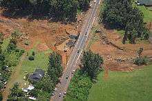
September 2013 Colorado floods
During the week starting September 9, a slow moving cold front stalled over Colorado, clashing with warm humid monsoonal air from the south.[28] This resulted in rain and flooding along Colorado's Front Range from Colorado Springs north to Fort Collins. The situation intensified on September 11 and 12. Worst hit was Boulder County, with up to 21 inches of rain recorded. At least 6 deaths along the Front Range have been attributed to the flooding,[29] and evacuations took place in many low-lying areas. The town of Lyons in Boulder County was isolated by the flooding of the St. Vrain River,[30] and several earth dams along the Front Range burst or were overtopped. As of late September 13, according to the Office of Emergency Management, there were 172 people unaccounted for and at least 3 dead in flood area of Boulder County.[31]
2014 Gulf Coast Flood
On April 29-30, 2014, a slow-moving cold front associated with a tornado outbreak in the Deep South dumped a record setting amount of rainfall, inundating the western Florida Panhandle and Southwest Alabama. Pensacola was estimated to have received as much as 26 inches of rain in only 25 hours, with 5.68 inches of it falling in only an hour at Pensacola International Airport.[32] A landslide caused a major portion of Scenic Highway in Pensacola to collapse into the bay it overlooks.[33] Areas east of Pensacola received as much as 15-20 inches of rain, peaking at 20.39 inches in Milton and 14.15 inches at Mary Esther.[32] The majority of this rainfall occurred in a time period of about 9 hours on the morning of April 30. In Alabama, rainfall amounts peaked at 23.67 inches in Orange Beach, and 17.20 inches in Mobile.[32]
2014 Southeastern Michigan flood
On August 11, 2014, historic flooding occurred in and around Detroit after a storm brought about five inches of rain in a period of several hours.[34] Many freeways across the area were heavily flooded, especially the Interstate 75/Interstate 696 interchange in Madison Heights, Michigan.
2014 New York flood
Record setting rainfall presenting 60 days of precipitation fell from the same system that precipitated the 2014 Southeastern Michigan flood two days earlier on suburbs of New York, New York.[35][36][37][38][39][40][41][42]
2014 Arizona flood
A record setting rainfall event deposited close to 3 inches of precipitation on the area, breaking the old record set in 1933.[43]
2015 Texas-Oklahoma flood
Weeks of heavy rain caused by a slow-moving front resulted in devastating floods across much of Texas and Oklahoma during the week of 24 May 2015.[44] Most notably, the town of Wimberley, Texas, along with a significant portion of Hays County was devastated when the Blanco River rose to almost 30 feet above flood stage overnight. Later that week, Houston also experienced widespread flash flooding in highly populated portions of the city as well.[45]
2015 Louisiana flood
The 2015 Louisiana floods took place during June 2015. The Red River of the South flooded parts of northern Louisiana. The Red River reached its highest level in over 70 years during the floods.[46]
2015 Utah floods
Heavy rain from the remnants of Hurricane Linda fell over southern Utah, causing flash floods in Zion National Park and the town of Hildale. The floods killed between 16 and 20 people.[47]
2015 Missouri floods
in December 2015, major floods occurred in Missouri.[48]
March 2016 Southern and Midwestern floods
In early March 2016, a dip in the jet stream and collection of moisture from the gulf caused a large, slow-moving weather system that produced torrential rains and severe weather as it made its way from Texas into the Mississippi Valley. On March 8, the storm hit northwest Louisiana, where it proceeded to create huge flood events in the area near Shreveport. Many neighborhoods around Red Chute Bayou and Flat River in Bossier Parish were quickly inundated and evacuated. In the neighborhood of Golden Meadows in Bossier City, the rapid rainfall overwhelmed storm drains and left people stranded in their homes with up to four feet of water in some areas. As the storm later moved east, the rest of North Louisiana was heavily impacted with up to twenty five inches of rain recorded in some areas such as Monroe. There were also many areas in other states such as Illinois, Texas, Oklahoma, Mississippi, Missouri, and Tennessee severely affected by this storm. Five deaths are directly attributed to this storm, and over 3500 people have been displaced.[49][50]
April 2016 Houston floods
In April 2016, Houston, Texas was flooded with over one foot of rain in 24 hours.[51]
May 2016 Oklahoma floods
The 2016 Oklahoma floods set precipitation records in both Texas[52] and Oklahoma.[53]
June 2016 West Virginia floods
July 2016 Maryland floods
2016 Louisiana floods
See also
- Floods in the United States before 1901
- Floods in the United States: 1901–2000
- United States tropical cyclone rainfall climatology
References
- ↑ Department of Commerce. Service Assessment: Tropical Storm Allison Heavy Rains and Floods Texas and Louisiana June 2001. Retrieved on 2006-11-30.
- ↑ NOAA. Service Assessment: Hurricane Katrina August 25-31, 2005. Retrieved on 2006-10-30.
- ↑ NewHampshire.com. NH Flood Information. Retrieved on 2007-05-05.
- ↑ National Weather Service Office, Honolulu, Hawaii. Unprecedented Extended Wet Period across Hawaii. Retrieved on 2006-10-30.
- ↑ National Weather Service Office, Lake Charles, Louisiana. Sam Shamburger and Montra Lockwood. Too Much of a Good Thing. Retrieved on 2006-10-28.
- ↑ National Weather Service Office, Lake Charles, Louisiana. Sam Shamburger. Water, Water Everywhere. Retrieved on 2006-10-28.
- ↑ National Weather Service Office, Shreveport, Louisiana. October 15-19, 2006 Heavy Rainfall Events. Retrieved on 2006-10-28.
- ↑ Associate Press. Kate Brumback. 9 Southeast storm deaths as floodwaters linger . Retrieved on 2009-09-22.
- ↑ "National Weather Service Climate". Weather.gov. Retrieved 2013-09-09.
- ↑ "Floodwater swallows inventory at Warwick Mall". Necn.com. 2010-04-02. Retrieved 2013-09-09.
- ↑ "Flood A 1000-Year Event". Knoxville News Sentinel. Retrieved 2010-05-06.
- ↑ "May 2010 flood: by the numbers". The Tennessean. May 1, 2011. Retrieved 2011-10-03.
- ↑ "Obama Signs Tennessee Disaster Declaration". Blog.memphisdailynews.com. May 9, 2011. Archived from the original on June 15, 2011. Retrieved 2011-05-16.
- ↑ "Levee breach lowers river, but record flooding still forecast". CNN. May 3, 2011. Retrieved 2011-05-03.
- ↑ "Rural Louisiana flooded to save New Orleans" (CBS News/Associated Press) May 14, 2011
- ↑ "U.S. Army Corps of Engineers Team New Orleans". Retrieved 2011-05-13.
- ↑ McPhee, John (February 23, 1987). "McPhee, The Control of Nature: Atchafalaya". Newyorker.com. Retrieved 2011-05-16.
- ↑ "Bonnet Carre Spillway, Norco, LA". Johnweeks.com. April 10, 2008. Retrieved 2011-05-16.
- 1 2 "Midwest Floods". Alert Worldwide: Air Worldwide. April 22, 2013. Retrieved May 20, 2013.
- ↑ Davey, Monica (April 25, 2013). "In Midwest, Drought Gives Way to Flood". New York Times. Retrieved May 20, 2013.
- ↑ Hillaker: The wettest spring in 141 years of records, KCCI 8 News, May 29, 2013
- ↑ Tim Schoon, Flood Preparations Begin, University of Iowa News Service, May 29, 2013.
- ↑ Iowa City Officials Asks Citizens to Prepare for Possible Flooding, Press Release, City of Iowa City, May 30, 2013
- ↑ "Corps "Opens The Gates" on Coralville Dam - KGAN-TV CBS 2 Iowa - Top Stories". Cbs2iowa.com. 2013-06-01. Retrieved 2015-12-29.
- ↑ Rick Smith, River crests in Cedar Rapids; flood response holding, Cedar Rapids Gazette, June 2, 2013.
- ↑ Recent Dry Weather Pattern Allows Corps To Decrease Reservoir Outflow Today, Press Release, City of Iowa City, June 13, 2013
- ↑ Dubuque Str4ee Reopens, City of Iowa City News Release, Iowa City Press Citizen, June 16, 2003.
- ↑ Tom McGhee (2013-09-12). "Colorado flood: No relief in sight as record rain falls". The Denver Post. Retrieved 2015-12-29.
- ↑ Steffen, Jordan. "Colorado flood: Front Range floodwaters kill three, drench homes". The Denver Post. Retrieved 2015-12-29.
- ↑ Young, Quentin. "National Guard carries evacuees from Lyons, delivers supplies". The Denver Post. Retrieved 2015-12-29.
- ↑ "172 People Now Unaccounted For In Boulder County". CBS News Denver. Retrieved 14 September 2013.
- 1 2 3 "North Central Gulf Coast Historic Flash Flood Event – 29-30 April 2014". Srh.noaa.gov. Retrieved 2015-12-29.
- ↑ "VIDEO: Portion of Scenic Highway has collapsed". Pnj.com. 2014-04-30. Retrieved 2015-12-29.
- ↑ "Metro Detroit | Detroit Free Press". Freep.com. Retrieved 2015-12-29.
- ↑ Archived August 13, 2014, at the Wayback Machine.
- ↑ Archived August 14, 2014, at the Wayback Machine.
- ↑ Bashan, Yoni (2014-08-13). "Record-Breaking Rain Floods Long Island, New York Region - WSJ". Online.wsj.com. Retrieved 2015-12-29.
- ↑ Kearney, Laila (2014-08-14). "New York suburbs hit by flash floods after record rainfall". Reuters. Retrieved 2015-12-29.
- ↑ "Wet Wednesday: Flooding rain swamps Northeast". Usatoday.com. 2014-08-13. Retrieved 2015-12-29.
- ↑ "Strong Storms Shatter Records on Long Island, Cars Nearly Submerged". NBC News. Retrieved 2015-12-29.
- ↑ "'Storm Of Historic Proportions' Dumps 13 Inches Of Rain In Some Spots Of LI « CBS New York". Newyork.cbslocal.com. 2014-08-13. Retrieved 2015-12-29.
- ↑ "One dead, several drivers rescued from stranded cars on flooded Long Island roads after record-setting rainstorm". NY Daily News. 2014-08-13. Retrieved 2015-12-29.
- ↑ "Record rainfall leads to deadly flooding in Arizona". CBS News. 2014-09-08. Retrieved 2015-12-29.
- ↑ "REPORTS: Damaging Storms Slam Texas With Major Flooding, Tornadoes". 26 May 2015.
- ↑ "Houston Floods Devastate Region". 26 May 2015.
- ↑ "News - Red River flooding: Highest level in 70 years". The Weather Network. 2015-06-12. Retrieved 2015-12-29.
- ↑ Reavy, Pat (16 September 2015). "16, possibly 20 die in devastating southern Utah flash floods". Deseret News. Retrieved 16 September 2015.
- ↑ "Evacuations Ordered Along Mississippi River; Nat. Guard Activated in Missouri". Weather.com. Retrieved 2015-12-29.
- ↑ Vagell, Quincy; Dolce, Chris; Erdman, Jon. "Over 23 Inches of Rain Triggers Historic Flash Flooding, River Flooding In Parts of the South". The Weather Channel. Retrieved 11 March 2016.
- ↑ Talamo, Alexa. "Flooding, evacuations continue in Caddo and Bossier parishes". The Shreveport Times. Gannett. Retrieved 11 March 2016.
- ↑ ABC News. "In Houston Nearly 900 Are Rescued as Severe Flooding Sweeps Through City". ABC News. Retrieved May 29, 2016.
- ↑ CNN, Joe Sutton, Madison Park and Mayra Cuevas -. "Seven dead after record-setting floods in Texas, Kansas". Retrieved June 10, 2016.
- ↑ "Texas and Oklahoma Set All-Time Record Wet Month; Other May Rain Records Shattered in Arkansas, Nebraska". Retrieved June 10, 2016.
- ↑ https://weather.com/news/weather/news/ellicott-city-maryland-flooding-saturday
- ↑ http://www.usatoday.com/story/news/nation-now/2016/07/31/floods-leave-ellicott-city-md-severely-damaged/87882130/