Flood control
Flood control refers to all methods used to reduce or prevent the detrimental effects of flood waters.[1] Flood relief refers to methods used to reduce the effects of flood waters or high water levels.
Causes of floods
Floods are caused by many factors (or a combination of any of these): heavy rainfall, highly accelerated snowmelt, severe winds over water, unusual high tides, tsunamis, or failure of dams, levees, retention ponds, or other structures that retained the water. Flooding can be exacerbated by increased amounts of impervious surface or by other natural hazards such as wildfires, which reduce the supply of vegetation that can absorb rainfall.
Periodic floods occur on many rivers, forming a surrounding region known as the flood plain.
During times of rain, some of the water is retained in ponds or soil, some is absorbed by grass and vegetation, some evaporates, and the rest travels over the land as surface runoff. Floods occur when ponds, lakes, riverbeds, soil, and vegetation cannot absorb all the water. Water then runs off the land in quantities that cannot be carried within stream channels or retained in natural ponds, lakes, and man-made reservoirs. About 30 percent of all precipitation becomes runoff[1] and that amount might be increased by water from melting snow. River flooding is often caused by heavy rain, sometimes increased by melting snow. A flood that rises rapidly, with little or no warning, is called a flash flood. Flash floods usually result from intense rainfall over a relatively small area, or if the area was already saturated from previous precipitation.
Severe winds over water
Even when rainfall is relatively light, the shorelines of lakes and bays can be flooded by severe winds—such as during hurricanes—that blow water into the shore areas.
Unusual high tides
Coastal areas are sometimes flooded by unusually high tides, such as spring tides, especially when compounded by high winds and storm surges.
Effects of floods
Flooding has many impacts. It damages property and endangers the lives of humans and other species. Rapid water runoff causes soil erosion and concomitant sediment deposition elsewhere (such as further downstream or down a coast). The spawning grounds for fish and other wildlife habitats can become polluted or completely destroyed. Some prolonged high floods can delay traffic in areas which lack elevated roadways. Floods can interfere with drainage and economical use of lands, such as interfering with farming. Structural damage can occur in bridge abutments, bank lines, sewer lines, and other structures within floodways. Waterway navigation and hydroelectric power are often impaired. Financial losses due to floods are typically millions of dollars each year, with the worst floods in recent U.S. history having cost billions of dollars.
Benefits of flooding
There are many disruptive effects of flooding on human settlements and economic activities. However, flooding can bring benefits, such as making soil more fertile and providing nutrients in which it is deficient. Periodic flooding was essential to the well-being of ancient communities along the Tigris-Euphrates Rivers, the Nile River, the Indus River, the Ganges and the Yellow River, among others. The viability for hydrologically based renewable sources of energy is higher in flood-prone regions.
Protection and control of floods
Some methods of flood control have been practiced since ancient times.[1] These methods include planting vegetation to retain extra water, terracing hillsides to slow flow downhill, and the construction of floodways (man-made channels to divert floodwater).[1] Other techniques include the construction of levees, lakes, dams, reservoirs,[1] retention ponds to hold extra water during times of flooding.
Methods of detection
This is the method used for remote sensing the disasters. Detection of disasters such as floods, Earthquakes, Explosions are quite complex in previous days and range of detection is inappropriate. But it came to possibilities by using Multi temporal visualization of Synthetic Aperture Radar (SAR)images. But to obtain the good SAR images perfect spatial registration and very precise calibration are necessary to specify changes that have occurred. Calibration of SAR is very complex and also a sensitive problem. Possibly errors may occur after calibration that involves data fusion and visualization process. Traditional image pre-processing cannot be used here due to the on-Gaussian of radar back scattering, but a processing method called "cross calibration/normalization" is used to solve this problem. The application generates a single disaster image called "fast-ready disaster map" from multitemporal SAR images. These maps are generated without user interaction and helps in providing immediate first aid to the people. This process also provides image enhancement and comparison between numerous images using data fusion and visualization process. This proposed processing includes filtering, histogram truncation and equalization steps. The process also helps in identifying the permanent waters and other classes by combined composition of pre-disaster and post-disaster images into a color image for better identity.[2]
Methods of controlling floods
Dams
Many dams and their associated reservoirs are designed completely or partially to aid in flood protection and control. Many large dams have flood-control reservations in which the level of a reservoir must be kept below a certain elevation before the onset of the rainy/summer melt season to allow a certain amount of space in which floodwaters can fill. The term dry dam refers to a dam that serves purely for flood control without any conservation storage (e.g. Mount Morris Dam, Seven Oaks Dam).
Water-Gate
The Water-Gate Flood barrier is a rapid response barrier which can be rolled out in a matter of minutes. It is unique in the way that it self deploys using the weight of water to hold it back. The product has been FM Approved following testing from the US Army. It is used in 30 countries around the world, and notably by the Environment Agency in the UK.
Diversion canals
Floods can be controlled by redirecting excess water to purpose-built canals or floodways, which in turn divert the water to temporary holding ponds or other bodies of water where there is a lower risk or impact to flooding. Examples of flood control channels include the Red River Floodway that protects the City of Winnipeg (Canada) and the Manggahan Floodway that protects the City of Manila (Philippines).
Self-closing flood barrier
The self-closing flood barrier (SCFB) is a flood defense system designed to protect people and property from inland waterway floods caused by heavy rainfall, gales or rapid melting snow. The SCFB can be built to protect residential properties and whole communities, as well as industrial or other strategic areas. The barrier system is constantly ready to deploy in a flood situation, it can be installed in any length and uses the rising flood water to deploy. Barrier systems have already been built and installed in Belgium, Italy, Ireland, the Netherlands, Thailand, United Kingdom, Vietnam, Australia, Russia and the United States. Millions of documents at the National Archives building in Washington DC are protected by two SCFBs.
River defences
In many countries, rivers are prone to floods and are often carefully managed. Defenses such as levees, bunds, reservoirs, and weirs are used to prevent rivers from bursting their banks. When these defenses fail, emergency measures such as sandbags, hydrosacks or portable inflatable tubes are used.
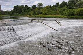
A weir, also known as a lowhead dam, is most often used to create millponds, but on the Humber River in Toronto, a weir was built near Raymore Drive to prevent a recurrence of the flood damage caused by Hurricane Hazel in 1954.
Coastal defences
Coastal flooding has been addressed in Europe and the Americas with coastal defences, such as sea walls, beach nourishment, and barrier islands.
Tide gates are used in conjunction with dykes and culverts. They can be placed at the mouth of streams or small rivers, where an estuary begins or where tributary streams, or drainage ditches connect to sloughs. Tide gates close during incoming tides to prevent tidal waters from moving upland, and open during outgoing tides to allow waters to drain out via the culvert and into the estuary side of the dike. The opening and closing of the gates is driven by a difference in water level on either side of the gate.[3]
Temporary perimeter barriers
In 1988, a method of using water to control was discovered. This was accomplished by containing 2 parallel tubes within a third outer tube. When filled, this structure formed a non-rolling wall of water that can control 80 percent of its height in external water depth, with dry ground behind it. Eight foot tall water filled barriers were used to surround Fort Calhoun Nuclear Generating Station during the 2011 Missouri River Flooding. Instead of trucking in sandbag material for a flood, stacking it, then trucking it out to a hazmat disposal site, flood control can be accomplished by using the on site water. However, these are not fool proof. A 8 feet (2.4 m) high 2,000 feet (610 m) long water filled rubber flood berm that surrounded portions of the plant was punctured by a skid-steer loader and it collapsed flooding a portion of the facility.[4]
In 1999, A group of Norwegian Engineers founded and patented Aquafence. A transportable, removable, and reusable flood barrier which uses the water's weight against itself. In 2013, AquaFence was awarded the highest level USA ANSI Certification after more than one year of testing of the system by US ARMY Corps of Engineers as well as parts testing and production review by FM Global. Both commercial and municipal customers spanning across The United States of America, Europe and Asia. In the US alone, AquaFence removable flood panels are protecting more than $10 billion worth of real estate as well as cities and public utilities.[5]
Property level protection
Property level protection is advocated as a method of trying to manage flood risk at the receptor (at a property or community scale).[6]
Flood control by continent
Americas
An elaborate system of flood way defenses can be found in the Canadian province of Manitoba. The Red River flows northward from the United States, passing through the city of Winnipeg (where it meets the Assiniboine River) and into Lake Winnipeg. As is the case with all north-flowing rivers in the temperate zone of the Northern Hemisphere, snow melt in southern sections may cause river levels to rise before northern sections have had a chance to completely thaw. This can lead to devastating flooding, as occurred in Winnipeg during the spring of 1950. To protect the city from future floods, the Manitoba government undertook the construction of a massive system of diversions, dikes, and flood ways (including the Red River Flood way and the Portage Diversion). The system kept Winnipeg safe during the 1997 flood which devastated many communities upriver from Winnipeg, including Grand Forks, North Dakota and Ste. Agathe, Manitoba.
In the United States, the U.S. Army Corps of Engineers is the lead flood control agency.[7] After Hurricane Sandy, New York City's Metropolitan Transportation Authority (MTA) initiated multiple flood barrier projects to protect the transit assets in Manhattan. In one case, the MTA's New York City Transit Authority (NYCT) sealed subway entrances in lower Manhattan using a deployable fabric cover system called Flex-Gate,[8] a system that protects the subway entrances against 14 feet (4.3 m) of water.[9] Extreme storm flood protection levels have been revised based on new Federal Emergency Management Agency guidelines for 100-year and 500-year design flood elevations.[10][11]
In the New Orleans Metropolitan Area, 35 percent of which sits below sea level, is protected by hundreds of miles of levees and flood gates. This system failed catastrophically, with numerous breaks, during Hurricane Katrina (2005) in the city proper and in eastern sections of the Metro Area, resulting in the inundation of approximately 50 percent of the metropolitan area, ranging from a few inches to twenty feet in coastal communities.
The Morganza Spillway provides a method of diverting water from the Mississippi River when a river flood threatens New Orleans, Baton Rouge and other major cities on the lower Mississippi. It is the largest of a system of spillways and floodways along the Mississippi. Completed in 1954, the spillway has been opened twice, in 1973 and in 2011.
In an act of successful flood prevention, the federal government offered to buy out flood-prone properties in the United States in order to prevent repeated disasters after the 1993 flood across the Midwest. Several communities accepted and the government, in partnership with the state, bought 25,000 properties which they converted into wetlands. These wetlands act as a sponge in storms and in 1995, when the floods returned, the government did not have to expend resources in those areas.[12]
Asia
In India, Bangladesh and China, flood diversion areas are rural areas that are deliberately flooded in emergencies in order to protect cities.[13]
The consequences of deforestation and changing land use on the risk and severity of flooding are subjects of discussion. In assessing the impacts of Himalayan deforestation on the Ganges-Brahmaputra Lowlands, it was found that forests would not have prevented or significantly reduced flooding in the case of an extreme weather event.[14] However, more general or overview studies agree on the negative impacts that deforestation has on flood safety - and the positive effects of wise land use and reforestation.[15][16]
Many have proposed that loss of vegetation (deforestation) will lead to an increased risk of flooding. With natural forest cover the flood duration should decrease. Reducing the rate of deforestation should improve the incidents and severity of floods.[17]
Africa
In Egypt, both the Aswan Dam (1902) and the Aswan High Dam (1976) have controlled various amounts of flooding along the Nile river.
Europe

Following the misery and destruction caused by the 1910 Great Flood of Paris, the French government built a series of reservoirs called Les Grands Lacs de Seine (or Great Lakes) which helps remove pressure from the Seine during floods, especially the regular winter flooding.[18]
London is protected from flooding by a huge mechanical barrier across the River Thames, which is raised when the water level reaches a certain point (see: Thames Barrier).
Venice has a similar arrangement, although it is already unable to cope with very high tides. The defenses of both London and Venice will be rendered inadequate if sea levels continue to rise.
The largest and most elaborate flood defenses can be found in the Netherlands, where they are referred to as Delta Works with the Oosterschelde dam as its crowning achievement. These works were built in response to the North Sea flood of 1953, in the southwestern part of the Netherlands. The Dutch had already built one of the world's largest dams in the north of the country. The Afsluitdijk closing occurred in 1932.
The Saint Petersburg Flood Prevention Facility Complex was completed in 2008, in Russia, to protect Saint Petersburg from storm surges. It also has a main traffic function, as it completes a ring road around Saint Petersburg. Eleven dams extend for 25.4 kilometres (15.8 mi) and stand 8 metres (26 ft) above water level.
Flood clean-up safety
Clean-up activities following floods often pose hazards to workers and volunteers involved in the effort. Potential dangers include electrical hazards, carbon monoxide exposure, musculoskeletal hazards, heat or cold stress, motor vehicle-related dangers, fire, drowning, and exposure to hazardous materials. Because flooded disaster sites are unstable, clean-up workers might encounter sharp jagged debris, biological hazards in the flood water, exposed electrical lines, blood or other body fluids, and animal and human remains. In planning for and reacting to flood disasters, managers provide workers with hard hats, goggles, heavy work gloves, life jackets, and watertight boots with steel toes and insoles.[19]
Future
Europe is at the forefront of the flood control technology, with low-lying countries such as the Netherlands and Belgium developing techniques that can serve as examples to other countries facing similar problems.[20]
After Hurricane Katrina, the US state of Louisiana sent politicians to the Netherlands to take a tour of the complex and highly developed flood control system in place in the Netherlands.[21] With a BBC article quoting experts as saying 70 percent more people will live in delta cities by 2050, the number of people impacted by a rise in sea level will greatly increase.[22] The Netherlands has one of the best flood control systems in the world and new ways to deal with water are constantly being developed and tested, such as the underground storage of water, storing water in reservoirs in large parking garages or on playgrounds,[22][23] Rotterdam started a project to construct a floating housing development of 120 acres (0.49 km2) to deal with rising sea levels.[24] Several approaches, from high-tech sensors detecting imminent levee failure to movable semi-circular structures closing an entire river, are being developed or used around the world. Regular maintenance of hydraulic structures, however, is another crucial part of flood control.[25]
See also
- Amphibious vehicle
- Cold drop
- Drowning
- Flash flood
- Flood barrier
- Flood wall
- Flood Control Act of 1934 (in the US)
- Hydrological Ensemble Prediction Experiment
- Hydrosacks
- Lifesaving
- Maeslantkering - Netherlands
- MOSE project - Venice
- Northern Stormwater Interceptor, Bristol (in the UK)
- Thames Barrier - London
- Tidal barrage
- Weir
References
Notes
- 1 2 3 4 5 "Flood Control", MSN Encarta, 2008 (see below: Further reading).
- ↑ IJERT International Journal of Engineering Research & Technology (IJERT) Vol. 3 Issue 4, April - 2014 http://www.aiming.in
- ↑ Guillermo R. Giannico; Jon A. Souder (2004). "The Effects of Tide Gates on Estuarine Habitats and Migratory Fish." (PDF). National Sea Grant College Program, Oregon State University, Corvallis, OR. Product No. ORESU-G-04-002.
- ↑ Wald, Matthew L. (June 27, 2011). "Nebraska Nuclear Plant's Vital Equipment Remains Dry, Officials Say". The New York Times.
- ↑ "Enlarge player → New weapon in the fight against flood damage". Fox News. Jul 31, 2014.
- ↑ Connelly, Angela; Gabalda, Vincent; Garvin, Stephen; Hunter, Katy; Kelly, David; Lawson, Nigel; O'Hare, Paul; White, Iain (2015-04-01). "Testing innovative technologies to manage flood risk". Proceedings of the Institution of Civil Engineers - Water Management. 168 (2): 66–73. doi:10.1680/wama.14.00063. ISSN 1741-7589.
- ↑ U.S. Army Corps of Engineers, Washington, DC."Civil Works." Accessed 2014-01-24.
- ↑ Schlossberg, Tatiana (October 29, 2015). "New York Today: In Hurricane Sandy's Wake". New York Today. New York Times. Retrieved December 3, 2015.
- ↑ "Anti-flood system rolled out in a lower Manhattan subway". Reuters. November 19, 2015. Retrieved December 3, 2015.
- ↑ "Flood Maps". Retrieved December 3, 2015.
- ↑ "How to Read a Flood Map". Retrieved December 3, 2015.
- ↑ Ripley, Amanda (2006-08-28). "Floods, Tornadoes, Hurricanes, Wildfires, Earthquakes... Why We Don't Prepare." Time.
- ↑ "China blows up seventh dike to divert flooding." China Daily. 2003-07-07.
- ↑ Hamilton, Lawrence S (1987). "What Are the Impacts of Himalayan Deforestation on the Ganges-Brahmaputra Lowlands and Delta? Assumptions and Facts". Mountain Research and Development. Bern: International Mountain Society. 7 (3): 256–263. doi:10.2307/3673202. JSTOR 3673202.
- ↑ Semi, Naginder S (1989). "The Hydrology of Disastrous floods in Asia: An Overview" (PDF). Hydrology and Water Resources Department. London: James & James Science Publishers. Retrieved 15 September 2010.
- ↑ Bradshaw, CJ; Sodhi, NS; Peh, SH; Brook, BW (2007). "Global evidence that deforestation amplifies flood risk and severity in the developing world". Global Change Biology. 13: 2379–2395. doi:10.1111/j.1365-2486.2007.01446.x.
- ↑ Bradshaw, CJ; Sodhi, NS; Peh, SH; Brook, BW (2007). "Global evidence that deforestation amplifies flood risk and severity in the developing. Also a flood has recently hit Pakistan which is said to be more devastating than the Tsunami of 2005". Global Change Biology. 13: 2379–2395. doi:10.1111/j.1365-2486.2007.01446.x.
- ↑ See Jeffrey H. Jackson, Paris Under Water: How the City of Light Survived the Great Flood of 1910 (New York: Palgrave Macmillan, 2010).
- ↑ National Institute for Occupational Safety and Health, Washington, DC (2013). "Storm/Flood and Hurricane/Typhoon Response." Emergency Response Resources.
- ↑ Woodard, Colin (2001-09-04). "Netherlands Battens Its Ramparts Against Warming Climate." Christian Science Monitor.
- ↑ Goldenberg, Suzanne (5 June 2009). "US urged to abandon ageing flood defences in favour of Dutch system". The Guardian. London.
- 1 2 "In pictures: Rotterdam strengthens sea defences". BBC News. 27 November 2009.
- ↑ http://water.dhv.com/EN/Water_management/Documents/2008%20Leaflet%20Innovative%20water%20storage%20techniques.pdf
- ↑ Palca, Joe (2008-01-28). "Dutch Architects Plan for a Floating Future." National Public Radio, Washington, DC.
- ↑ Broad, William J. (6 September 2005). "In Europe, High-Tech Flood Control, With Nature's Help". The New York Times.
Further reading
- "Flood Control". MSN Encarta. 2008. Archived from the original on 2009-10-31.
External links
| Wikimedia Commons has media related to Flood control. |
- Integrated Flood Management - Associated Programme on Flood Management, Geneva
- Flood articles - BBC News
- Flood defence works in Wiltshire - BBC
- Flood defence works in Carlisle - BBC
- Flood management and restoration of habitats - BBC
| Air |
|  | ||||||
|---|---|---|---|---|---|---|---|---|
| Energy | ||||||||
| Land | ||||||||
| Life | ||||||||
| Water |
| |||||||
| Related |
| |||||||
| ||||||||
| ||||||||