Flinders Street, Melbourne
| Flinders Street Victoria | |
|---|---|
 | |
| Flinders Street, facing east from the intersection of Elizabeth Street | |
| General information | |
| Type | Street |
| Length | 2 km (1.2 mi) |
| Route number(s) |
|
| Major junctions | |
| West end |
Docklands, Melbourne |
| |
| East end |
East Melbourne, Melbourne |
| Location(s) | |
| Suburb(s) | Melbourne CBD |
| |
Flinders Street is a notable street in Melbourne, Victoria, Australia. Running roughly parallel to the Yarra River, Flinders Street forms the southern edge of the Hoddle Grid. It is exactly one mile (1609.344 m) in length and one and half chains (30.1752 m) in width. It is named for the explorer Matthew Flinders, who was (erroneously) credited with discovering Port Phillip at the time of its naming. It extends eastwards as far as Spring Street and the Treasury Gardens, and westwards past Batman's Hill to the Melbourne Docklands. As the closest street to the river, Flinders Street serviced Melbourne's original river port. Customs House, now the site for Victoria's Immigration Museum, is situated on Flinders Street.
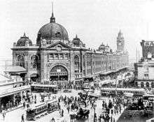

The street is home to Flinders Street Station, the central station in Melbourne's suburban rail network. Tram routes 70 and 75, as well as the City Circle route, run along Flinders Street, and the Flinders Street Viaduct runs parallel to the street, linking the city's two major railway stations.
Other landmarks on Flinders Street include Federation Square, St Paul's Cathedral, Young & Jackson, the Banana Alley Vaults, the old Herald and Weekly Times building, Melbourne Aquarium and Batman Park, which adjoins the Yarra River. It was once home to the Melbourne Fish Market, an ornate building constructed in 1890, covering 23,000 square metres, and of similar design to Flinders Street Station. The market was demolished between 1958 and 1960 after which the site became a public carpark. The site is now home to the three towers of the Northbank Place complex which includes office space, residential apartments, retail outlets and a multi-level carpark.
King Street Overpass
An overpass was built over the intersection with King Street as part of the construction of Kings Way. It extended from Downie Street to just east of Custom House Lane. The overpass opened in stages with trams using it from early 1960[1] and other traffic from mid 1960.[2] Many businesses and properties were overshadowed by the overpass which resulted in property values dropping and the closure of hotels, shops and showrooms. Plans to revitalise the area in the early 1960s never eventuated.
In April 2005, the State Government announced a plan to revitalise the south west corner of the CBD with the overpass destined for demolition.[3] The project commenced in June and concluded in August[4] bringing four and a half decades of depression in the area to an end.
See also
![]() Australian Roads portal
Australian Roads portal
References
- ↑ "New Overpass is Open to Traffic". Melbourne: The Age. 6 July 1960.
- ↑ "City Overpass Now Open Both Ways". Melbourne: The Age. 12 August 1960.
- ↑ "Flinders Street Overpass Demolition to Start". Media Release: Minister for Major Projects. www.dpc.vic.gov.au. 17 April 2005.
- ↑ "Flinders Street Overpass Bites The Dust". Media Release: Minister for Major Projects. www.dpc.vic.gov.au. 11 August 2005.
Coordinates: 37°49′07″S 144°57′49″E / 37.8186°S 144.9637°E