Fletschhorn
| Fletschhorn | |
|---|---|
|
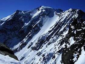
North face of the Fletschhorn | |
| Highest point | |
| Elevation | 3,985 m (13,074 ft) |
| Prominence | 297 m (974 ft) [1] |
| Isolation | 1.1 km (0.68 mi) [2] |
| Parent peak | Lagginhorn |
| Coordinates | 46°10′4″N 8°0′11″E / 46.16778°N 8.00306°ECoordinates: 46°10′4″N 8°0′11″E / 46.16778°N 8.00306°E |
| Geography | |
 Fletschhorn Location in Switzerland | |
| Location | Valais, Switzerland |
| Parent range | Pennine Alps |
| Climbing | |
| First ascent | August 1854 by Michael Amherdt and his guides Johannes Zumkemmi and Friedrich Clausen |
| Easiest route | Basic snow climb from Weissmies hut (2,726 m) |
The Fletschhorn (3,985 m) is a mountain of the Pennine Alps, located between the Saas Valley and the Simplon Valley, in the canton of Valais. It lies in the Weissmies group, north of the Lagginhorn. The Fletschhorn is shown to be 3,993 metres high on the 1:200'000 Swisstopo map. However, the largest-scale map (1:25'000) indicates a precise elevation of 3,984.5 metres above sea level.
It was first climbed by Michael Amherdt and his guides Johannes Zumkemmi and Friedrich Clausen in August 1854.[3][4] The imposing north face was first ascended by E. R. Blanchet with guides Oskar Supersaxo and Kaspar Mooser on 25 July 1927.

The Fletschhorn from the north
References
- ↑ Retrieved from the Swisstopo topographic maps. The key col is the Fletschjoch (3,688 m)
- ↑ Retrieved from Google Earth. The nearest point of higher elevation is north of the Lagginhorn.
- ↑ Gottlieb Studer: Ueber Eis und Schnee: Die höchsten Gipfel der Schweiz und die Geschichte ihrer Besteigung. p. 245–250, J. Dalpsche Buchhandlung, Bern 1870 (online)
- ↑ M. Ulrich: Chronik des SAC vom Jahre 1869. In: Jahrbuch des Schweizer Alpenclub. p. 512, Volumes 5–6, Bern 1870 (online)
External links
![]() Media related to Fletschhorn at Wikimedia Commons
Media related to Fletschhorn at Wikimedia Commons
- "Fletschhorn". SummitPost.org.
This article is issued from Wikipedia - version of the 9/20/2016. The text is available under the Creative Commons Attribution/Share Alike but additional terms may apply for the media files.