Flat Top, West Virginia
For other uses, see Flat Top (disambiguation).
| Flat Top, West Virginia | |
|---|---|
| Unincorporated community | |
 Flat Top, West Virginia | |
| Coordinates: 37°35′22″N 81°06′24″W / 37.58944°N 81.10667°WCoordinates: 37°35′22″N 81°06′24″W / 37.58944°N 81.10667°W | |
| Country | United States |
| State | West Virginia |
| County | Mercer |
| Elevation | 3,751 ft (1,143 m) |
| Time zone | Eastern (EST) (UTC-5) |
| • Summer (DST) | EDT (UTC-4) |
| ZIP code | 25841 |
| Area code(s) | 304 & 681 |
| GNIS feature ID | 1539061[1] |
Flat Top is an unincorporated community in Mercer County, West Virginia, United States. Flat Top is located on U.S. Route 19 19 miles (31 km) south of Beckley.
Flat Top is home of Mavis Manor a Queen Anne style, Victorian manor house and one of southern West Virginia first Farmstay.
The community takes its name from the level highlands upon which it is situated—the "flat top," which follows the crest of "Great Flat Top Mountain" for nearly 30 miles, from the New River Gorge, in the northeast, to the Virginia border in the southwest. The Lilly Monument, erected to honor the memories of settlers Robert and Fannie Lilly, overlooks the community from a knoll to its northeast.
References
Municipalities and communities of Mercer County, West Virginia, United States | ||
|---|---|---|
| Cities | 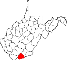 | |
| Towns | ||
| CDPs | ||
| Other communities |
| |
| Ghost town | ||
| Footnotes | ‡This populated place also has portions in an adjacent county or counties | |
This article is issued from Wikipedia - version of the 9/4/2016. The text is available under the Creative Commons Attribution/Share Alike but additional terms may apply for the media files.