Five Dock, New South Wales
| Five Dock Sydney, New South Wales | |||||||||||||
|---|---|---|---|---|---|---|---|---|---|---|---|---|---|
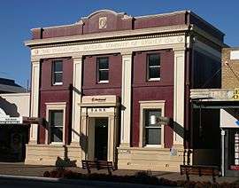 Old bank building on Great North Road, Five Dock | |||||||||||||
| Population | 8,747 (2011 census)[1] | ||||||||||||
| • Density | 3,570/km2 (9,247/sq mi) | ||||||||||||
| Established | 1794 | ||||||||||||
| Postcode(s) | 2046 | ||||||||||||
| Area | 2.45 km2 (0.9 sq mi) | ||||||||||||
| Location | 10 km (6 mi) west of Sydney CBD | ||||||||||||
| LGA(s) | City of Canada Bay | ||||||||||||
| State electorate(s) | Drummoyne | ||||||||||||
| Federal Division(s) | Reid | ||||||||||||
| |||||||||||||
Five Dock is a suburb in the Inner West[2] of Sydney, in the state of New South Wales, Australia. Five Dock is located 10 kilometres west of the Sydney central business district, in the local government area of the City of Canada Bay.
Location
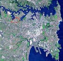
Five Dock lies roughly at the foot, or southern end, of the Drummoyne peninsula. More precisely, Five Dock lies between Parramatta Road and the City West Link Road to the south and Hen and Chicken Bay, on the Parramatta River, along with the suburbs of Wareemba and Russell Lea, to the north. Its total area is 2.45 km².[3]
Rodd Point lies to the east. Haberfield adjoins Five Dock to the south-east. Iron Cove forms a small section of the suburb's eastern boundary. Ashfield and Croydon lie on the other side of Parramatta Road, to the south. The suburbs of Canada Bay and Concord adjoin Five Dock's western boundary. Burwood lies just beyond Croydon, to the south-west.
From the heart of the shopping centre, it is approximately 7.5 kilometres to Sydney's central business district, measured in a straight line from the original Sydney General Post Office in Martin Place. By road, this same distance is about 9-10 kilometres, depending on the route taken.[4]
Originally, the local post office was called the "Wareemba Locality store", but after the geographical location was changed it was the named to the "Wareemba Post Office".
History

Indigenous heritage
Governor Phillip's notes suggest that an outbreak of smallpox in early 1789 would have had a devastating impact on the indigenous population in Canada Bay.

Origin of the name
The earliest written reference to Five Dock is in The Sydney Gazette of 3 February 1805, which mentions Five Dock Bay. However, the name probably dates back to the days of the First Settlement. All of the sources referenced are in agreement that it was derived from the shape of the bay along the Parramatta River.
According to a publication from the Maritime Services Board, Port of Sydney, (Volume 9, No 3, September 1965), "At the NE point of the bay there were five water worn indentations that were likened to docks, hence the name Five Dock." [5] There is widely contradictory information, however, about how many of these natural formations still exist. The Maritime Services Board publication concludes that there "are two of the five remaining". However, Eric Russell's Drummoyne: a western suburbs' history from 1794 states that one was lost with the construction of the 1881 Gladesville Bridge, but "the others remain in 1982". Other sources give different numbers again.


Local names
Many Five Dock streets are named after mayors, aldermen and other associated with local government, including Charles Street, Corden Avenue, Henley Marine Drive, Hill Street, Howley Street, Ingham Avenue, Kerin Avenue, McGrath Avenue, McKinnon Avenue, Myler Street, Preston Avenue, Sutton Street, Timbrell Drive, Udall Avenue, West Street and William Street.
Another series of streets is named after early landowners, subdividers and prominent local businessmen, including Ramsay Road, Taylor Street, Mitchell Street, Betts Avenue, Friend Avenue, Harris Road, Gildea Avenue and Bennett Avenue. Rickard Street, Noble Street, Heath Street and Augusta Street were named after Sir Arthur Rickard and members of his family. Rodd Road, Trevanion Street and Barnstaple Road are named after Brent Clements Rodd and members of his family. A few streets take their name from local residents, including Mackaness Close and Langsworth Way.
The Great White Fleet visited Sydney in August 1908 and several local street names recall ships in the fleet. Connecticut Avenue is named after the USS Connecticut (BB-18). Illinois Street is named after the USS Illinois (BB-7). Minnesota Avenue takes its name from the USS Minnesota (BB-22). New Jersey Road takes its name from the USS New Jersey (BB-16).
A few streets are named after prominent people: Queens Road after Queen Victoria; Garfield Avenue after American President James Garfield, Kingsford Avenue after Charles Kingsford Smith, Bevin Avenue after Ernest Bevin and Henry Lawson Avenue after Henry Lawson, who lived on Great North Road briefly in 1922. The name of Coronation Avenue commemorates the coronation of King George VI and Queen Elizabeth.
Churches

St Alban's Anglican Church[6] is a 1924 Gothic church, constructed of brick and stone. It is well-built church, using locally quarried stone, and remains very well preserved. It is a heritage item and is listed in the Department of the Environment and Heritage's Australian Heritage database.[7] Significant or attractive features of the church include its interior carpentry, the pipe organ (which dates from 1891 and was built by W. Davidson) and its stained glass. St Alban's rectory is on the same large site as the church, and together they form an important group. The foundations of the rectory, like those of the church, are constructed of local stone. In 2008 the church was part of an amalgamation with the Parishes of Ashfield and Haberfield, forming Christ Church Inner West Anglican Community.[8]
Schools
All Hallows' Parish School, Domremy College, Five Dock Public School, Lucas Gardens School, Rosebank College.
The foundation stone of Five Dock Public School was laid in the grounds of St Albans church in 1858,[9] and it opened in 1861. Peter Dodds McCormick who composed the national anthem of Australia, Advance Australia Fair, was the headmaster of Five Dock Public School in 1865.
Domremy College Five Dock
Named after Joan of Arc's birthplace, Domremy, Domremy College is a Catholic Secondary School for girls. It is located on First Avenue, opposite Five Dock Park. The school was founded in 1911, initially having just 12 students. The school originally taught students from infants through to the end of senior school. This was later scaled back to just years 7 to 10. However, since 1985, the school has taught girls from year 7 through to year 12. The Domremy Convent group is listed on the NSW Heritage Office State Heritage Register.[10]
Houses

Housing in Five Dock consists mainly of detached dwellings. Like many suburbs in the inner-west of Sydney, Five Dock has some well-preserved examples of Australian Federation architecture and California Bungalow style residences. Many of these homes have been renovated however, and have not retained all of their original features.
Many dwellings in Five Dock are detached houses, frequently with generously sized gardens. According to the 2011 census, of the 3,760 dwellings in the suburb, 1,676 consist of separate houses, 472 were other types of houses and 1,228 were flats or apartments.[1] Despite the preponderance of houses, Post-World War II development has involved a high proportion of apartment construction. Recently, several major residential developments have been completed. An example is the 'Pendium' development in Garfield Street, which includes 102 apartments, a refurbished supermarket and the local library. Another recent example is the redevelopment of the former EnergyAustralia site in Fairlight Street into 93 units .
As of October 2005, there are a total of 51 items in the suburb that are heritage listed by the NSW Heritage Office. In addition, the skateboard track in Five Dock Park is being considered for listing as a heritage item under the State Heritage Items Project .

Commercial area
The Five Dock retail and commercial centre is made up of a long line of shops, banks, restaurants and other services which run for about 500 metres along Great North Road in a section between Lyons Road and Queens Road. It features a high proportion of small local businesses. There are a number of shops selling Italian foods which reflects the number of residents of Italian background. The Five Dock telephone exchange is located at 190-192 Great North Road.
Parks
Five Dock has two separate stretches of publicly accessible foreshore on the Parramatta River. One of these foreshore stretches constitutes a small section of the Bay Run, a popular 7 km walking and cycling track which passes through several other suburbs along its way around Iron Cove. The other foreshore area lies on Hen and Chicken Bay and Kings Bay, and features a pedestrian and bike path leading around the bay towards Abbotsford.
In addition, there are several public parks located around Five Dock, the three largest being Timbrell Park, Five Dock Park and Halliday Park. A large section of Barnwell Park Golf Course, which is owned by Canada Bay Council, is located in Five Dock. The northern part of the golf course lies on reclaimed land.
Five Dock Park and Oval
Five Dock Park is listed on the NSW Heritage Office State Heritage Register and centres around The Five Dock War Memorial. The plaque at the memorial says that the foundation stone was laid in 1923. The memorial was renovated and rededicated in 1987. The park also contains a number of recreational facilities, including a large skate boarding area, a bowling club, tennis courts, an oval (used for junior rugby league matches and cricket), childcare facilities and an off-leash area for dogs. Originally constructed in 1979, the park's skate boarding and bmx area was extremely popular during the 1980s but gradually fell into disrepair. An article published in the Village Voice in 2002 said the National Skateboarders' Association had nominated Five Dock skate park as one of the three worst in NSW because it was in such a poor condition, with a subsequent article discussing calls for its upgrade. The new skatepark opened in 2007 was built next to the 'old bowl' and was designed by Mick Mulhall..
Transport
The major regional roads that run through or adjoin Five Dock include Parramatta Road, Lyons Road, Queens Road, Great North Road and the City West Link.
Five Dock is well-connected to the city centre and surrounding suburbs by public Sydney bus routes.
Croydon Station was originally named Five Dock Station when it opened in 1875. The name was changed to Croydon soon afterwards.
Population

Demographics
Five Dock is an established suburb with a population of 8,747 in the 2011 census. Like the nearby suburbs of Haberfield and Leichhardt, Five Dock has a large population of Italian immigrants. According to the 2011 census about 1 in 5 residents claim Italian ancestry and roughly 10% of the population was born in Italy.[1] This Italian influence is reflected in several ways, for instance in the style of the suburb's restaurants, cafes and delis. Five Dock Public School has had an Italian language teaching program since 1981 and there are local private language schools offering Italian classes. In addition, Five Dock has an annual street festival called Ferragosto, based on the traditional Italian festival of the same name.[11]
Notable residents
- John Harris, a military surgeon and magistrate, one of the first European landowners.
- Samuel Lyons, (1798-1851) a former English-born convict who became a wealthy landowner and prominent Australian citizen, purchasing Five Dock Farm in 1838.
- Sir Thomas Henley, alderman and mayor of Drummoyne who was largely responsible for the reuniting of Five Dock and Drummoyne Councils in 1902.
- Peter Dodds McCormick, (born in Scotland, c1834-1916 - Waverley, New South Wales) the composer of Australian National anthem, Advance Australia Fair, became headmaster of Five Dock Public School in 1865.[12]
- Jeff Fenech, boxer.[13]
Politics
Five Dock is in the federal seat of Reid, an electoral division which includes the surrounding suburbs of Burwood, Concord, Drummoyne, Haberfield, Homebush, Mortlake, Rhodes and Strathfield. A Labor seat since its inception in 1922, it elected a Liberal member for the first time in the 2013 federal election.
In the NSW parliament, Five Dock is in the electoral division of Drummoyne, which is somewhat smaller than the federal division, but occupies much of the same area.
Gallery
 Older style shops on Garfield Street with new development in the background.
 Great North Road, view to Parramatta Road
 Italian deli on Great North Road
 War Memorial in Five Dock Park
 The skate bowl in Five Dock Park
 Iron Cove Creek at Timbrell Park
 Ferragosto Festival street stalls
References
- 1 2 3 Australian Bureau of Statistics (31 October 2012). "Five Dock (State Suburb)". 2011 Census QuickStats. Retrieved 4 May 2013.
- ↑ Australian Suburb Guide: Sydney Inner West Archived 26 December 2012 at the Wayback Machine. Retrieved 8 August 2013.
- ↑ City of Canada Bay Council | Home
- ↑ Approximate measurements made using Sydney and Blue Mountains 2004 Street Directory, UBD, 40th Edition, ISBN 0-7319-1465-1 and Bikely.
- ↑ "Five Dock". Geographical Names Register (GNR) of NSW. Geographical Names Board of New South Wales.
- ↑ http://www.stalbanschurch.com.au
- ↑ "Place ID 102001". Australian Heritage Database. Department of the Environment.
- ↑ Smith, Joseph (28 December 2007). "New Year = New Parish". Southern Cross. The Anglican Diocese of Sydney. ISSN 1445-0089.
- ↑ "RELIGIOUS MEMORANDA.". The Sydney Morning Herald. NSW. 9 October 1858. p. 5. Retrieved 26 May 2011.
- ↑ Heritage Branch Website - Online Database
- ↑ "Ferragosto 2013". City of Canada Bay. Retrieved 4 May 2013.
- ↑ "Peter Dodds McCormick". Retrieved 4 May 2013.
- ↑ http://www.smh.com.au/articles/2004/01/05/1073151241374.html
Further reading
- Blaxell, Gregory. The River: Sydney Cove to Parramatta. Eastwood, N.S.W.: Brush Farm Historical Society, 2004. ISBN 0-9751419-1-0.
- Pollon, Francis (compiler). The Book of Sydney Suburbs. North Ryde, N.S.W.: Angus & Robertson, Revised Edition, 1991. ISBN 0-207-14495-8.
- Russell, Eric. Drummoyne: a western suburbs' history from 1794. Drummoyne, N.S.W.: Council of the Municipality of Drummoyne, Second Edition, 1982. ISBN 0-9599312-1-X.
- "Canada Bay Suburbs". The Sydney Inner West Virtual Library (SIWVL). Archived from the original on 15 June 2005. Retrieved 25 June 2005.
- "The Surgeon John Harris". John Harris Lindsay. Retrieved 29 June 2005.
- "Historical Highlights for Five Dock Public School". Department of Education and Training - Schools Hosting. Archived from the original on 9 February 2006. Retrieved 23 September 2005.
| Wikimedia Commons has media related to Five Dock, New South Wales. |
Coordinates: 33°51′54″S 151°07′43″E / 33.86512°S 151.12856°E