The Firehole River is located in northwestern Wyoming, and is one of the two major tributaries of the Madison River. It flows north approximately 21 miles (34 km) from its source in Madison Lake on the Continental Divide to join the Gibbon River at Madison Junction in Yellowstone National Park. It is part of the Missouri River system.
Description
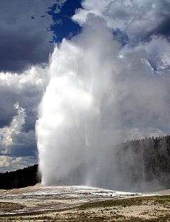
The Firehole River flows through several significant geyser basins in the park to include the Upper Geyser Basin, which contains the world-famous geyser Old Faithful. The river was named by early trappers for the steam that makes it appear to be smoking as if on fire.[2]
The Firehole contains three of Yellowstone's major waterfalls: Kepler Cascades south of Old Faithful, Firehole Falls and the Cascades of the Firehole in Firehole Canyon.[3]
The river is surrounded by geothermal features which empty water into it. One effect of the input of this water is to increase the temperature of the water. Temperatures in the river have been measured as high as 30 °C (86 °F) and average 5 to 10 °C (9 to 18 °F) higher than areas upstream of geothermal influence.[4]
Water entering the river from geothermal features contains dissolved chemicals and minerals. Levels of boron and arsenic have been found to be above the standard limits for protection of aquatic organisms. Despite these levels, brown and rainbow trout live and spawn in the river.[4]
Firehole River has been a fishing mecca since the late 19th century and is known today for its excellent fly fishing.[5][6]
The river contains an invasive species, the New Zealand mud snail (Potamopyrgus antipodarum).[7]
Sections
| Section |
Description,[8][9] |
| Biscuit Basin to Midway Geyser Basin |
As the Firehole crosses the Grand Loop Road South of Old Faithful, it joins the Little Firehole river in Biscuit Basin. The upper reaches of this section are classic meadow water. When the river leaves Biscuit Basin it parallels the Grand Loop Road for about 3 miles (4.8 km) and is generally less than 1/2 mile away from the road until it reaches the old Fountain Flats Freight road at the Old Iron Bridge. This stretch flows through sparsely forested lodgepole pines. Just before the river reaches Midway Geyser Basin it makes a very distinct U-turn in an area known as Muleshoe Bend. |
| Midway to Ojo Caliente Spring |
There is a long riffle from the lower end of Muleshoe through Midway Geyser Basin. It is right beside the road and is an excellent piece of water for the beginner. It is loaded with insect life, mostly small, and the rough, but not too uneven bottom offers good footing. Below Excelsior Spring, which pours a steaming cataract of 200 degree Fahrenheit water into the river, there is a long, shallow stretch of relatively fishless water leading into the head of Goose Lake Meadows, a long piece of mostly gliding dry fly water. From mid-July till late September this is a grasshopper stretch par excellence. A small falls and plunge pool terminates the stretch and gives way to a continuing succession of shallow cataracts. This ends in a narrow chute sliding under the Lower Iron Bridge and on into Ojo Caliente Bend, a deep, weed-filled curve that hosts more big trout than any stretch on the Firehole. The fishing on this section is generally very poor during the warmest months of summer—July and August. |
| Ojo Caliente Spring to Nez Perce Creek |
In Ojo Caliente Bend itself the abundant weeds make fishing difficult. This is true of all the weedy stretches, which includes all the slower, deeper waters from Biscuit Basin to the lip of the canyon. This section is loaded with caddis and scud. Below Ojo Caliente begins a long piece of water which traverses Fountain Flats. It is fairly even bottomed and its depth is also even, but there are some potholes and broken places in the bedrock bottom, though no really deep spots. The grass-covered banks are undercut throughout and this plus the potholes and some weeds furnish more holds for trout than at first appears. The water is a bit cooler than that of Ojo Caliente Bend. In spring this is a favored piece of water, especially for the nymph fisherman. In summer the Fountain Flats are the dry fly fisher's bane—and delight. The water is truly wonderfully propitious for the dry fly, but this open meadow is often assaulted with winds up to fifty miles an hour. It has always been so. Ray Bergman, in the thirties, speaks of winds so strong that he had to aim his cast 45 degrees away from the river's edge in order to drop the fly along the bank where the fish were holding. But wind or no, this is a very popular piece of water in summer and early fall—grasshopper time and the wind is a help here, blowing these ungainly creatures into the water and bringing the fish to feed. |
| Nez Perce Creek to Madison Junction |
Shortly after the Firehole leaves Fountain Flats, Nez Perce Creek enters the river from the East. The first three miles (5 km) of this section is mostly riffle and boulder water through Lodgepole forest to the breakover above the canyon head, is smooth, well weeded, very tempting to the dry fly fisher. These are the Broads of the Firehole. Ernest Schwiebert claimed that they must have been so named by some of the Englishmen who fly-fished these waters in the early history of the park. The Broads section parallels the Grand Loop Road and is rarely out of sight. At the three mile (5 km) point, the river drops into two mile (3 km) long Firehole Canyon, over Firehole Cascades, and over Firehole Falls. This is very rough and rocky terrain, but paralleled by the one-way Firehole Canyon Drive. When the river exits the canyon, it is a mere 2,000 feet (610 m) from the National Park Meadow and its confluence with the Gibbon at Madison Junction. |
Tributaries
Significant tributaries of the Firehole are the Little Firehole River, Fairy Creek, Iron Spring Creek, Sentinel Creek and Nez Perce Creek. All these tributaries bring cool waters to the Firehole and provide refuge for trout in the mainstem during mid-summer high temperatures caused by geothermal activity.[10]
Angling
The Firehole River is a famous and storied destination for serious fly fishermen. When it was discovered in the 1830s by American explorers, the Firehole was barren of trout above what is now called Firehole Falls. Brook trout were first introduced to the upper Firehole in 1889, while brown trout, the river's most plentiful trout today, was first stocked in 1890. Rainbow trout were not introduced until 1923. Mountain whitefish are native to the Firehole below Firehole Falls. By the late 19th century, the Firehole and Yellowstone National Park in general was a popular destination for fishermen. In 1955 all stocking programs in the park were discontinued and today's Firehole trout are completely wild populations. In 1968, based on increasing pressure on the Firehole, the Gibbon and Madison rivers, the National Park Service designated these waters as Fly Fishing Only.[6]
From one of the earliest accounts of fly fishing in Yellowstone:
The Fire hole is a companionable river. Notwithstanding its forbidding name, it is pre-eminently a stream for the angler, and always does its best to put him at his ease. Like some hospitable manorial lord, it comes straight down the highway for a league to greet the stranger and to offer him the freedom of its estate. Every fisherman who goes much alone along streams will unconsciously associate certain human attributes with the qualities of the waters he fishes. It may be a quiet charm that lulls to rest, or a bold current that challenges his endurance and caution. Between these extremes there is all that infinite range of moods and fancies which find their counterpart in the emotions. The Firehole possesses many of these qualities in a high degree. It can be broad, sunny and genial, or whisper with a scarcely audible lisp over languid, trailing beds of conferva; and anon, lead you with tumultuous voice between rocky walls where a misstep would be disastrous.— Klahowya, Fly Fishing in Wonderland, 1910[11]
In books
In 2005, Raymond Keift published Firehole River Murder: Yellowstone Fly-Fishing Mystery Series, a story about a wealthy but obnoxious businessman who was murdered on the banks of the Firehole River in Yellowstone.[12]
Gallery
| Images of the Firehole River |
|---|
| Firehole River upstream from Ojo Caliente bend, 1872 |
| Firehole River at Midway Geyser Basin, 1875 |
| Excelsior Geyser runoff, 1916 |
| Heavy runoff from Excelsior Geyser to Firehole River |
| Fountain Flats on The Firehole in September |
| Firehole River as the sun sets |
| Muleshoe Bend, Firehole River, a famous fly fishing location |
| Firehole River Just Downstream From Biscuit Basin Meadows |
| Firehole River As It Enters National Park Meadow |
| Typical Firehole River Brown Trout taken on an olive Woolly Bugger at Muleshoe Bend. (Released) |
| A man fly fishing the Firehole near Ojo Caliente Bend |
| Sentinel Creek enters the Firehole River at Fountain Flats |
| Meadows below Midway Geyser Basin |
| Ojo Calienté Bend below 1st Iron Bridge on Fountain Flats Freight Road |
|
See also
References
- 1 2 U.S. Geological Survey Geographic Names Information System: Madison River, USGS GNIS
- ↑ "Firehole River". Yellowstone National Park. Retrieved 2005-09-16.
- ↑ Rubenstein, Paul; Whittlesey, Lee H. (2000). The Guide to Yellowstone Waterfalls and their Discovery. Neenah, WI: Big Earth Publishing. pp. 33–37. ISBN 978-1-56579-351-4.
- 1 2 Goldstein JN, Hubert WA, Woodward DF, Farag AM, Meyer JS (2001). "Naturalized salmonid populations occur in the presence of elevated trace element concentrations and temperatures in the Firehole River, Yellowstone National Park, Wyoming, USA.". Environmental Toxicology and Chemistry. 20 (10): 2342–52. doi:10.1897/1551-5028(2001)020<2342:NSPOIT>2.0.CO;2. PMID 11596769.
- ↑ "Natural Highlights of the Old Faithful Area". Yellowstone National Park. Retrieved 2005-09-16.
- 1 2 Brooks, Charles E. (1979). The Living River-A Fisherman's Intimate Profile of the Madison River Watershed—Its History, Ecology, Lore and Angling Opportunities. Garden City, NJ: Nick Lyons Books. pp. 56–59. ISBN 0-385-15655-3.
- ↑ "Stop Aquatic Nuisance Species" (PDF). Retrieved 2012-03-27.
- ↑ Brooks, Charles E. (1984). Fishing Yellowstone Waters. Clinton, NJ: New Win Publishing Inc. ISBN 0-8329-0353-1.
- ↑ Parks, Richard (1998). Fishing Yellowstone National Park. Helena, MT: Falcon Press. ISBN 1-56044-625-0.
- ↑ Mathews, Craig; Molinero, Clayton (1997). The Yellowstone Fly-Fishing Guide-A authoritative guide to the waters of Yellowstone National Park. Guilford, CT: The Lyons Press. pp. 123–155. ISBN 1-55821-545-X.
- ↑ Klahowya (1910). Fly Fishing in Wonderland. Chicago: O. P. Barnes. p. 45.
- ↑ Keift, Raymond (2005). Firehole River Murder: Yellowstone Fly-Fishing Mystery Series. Bloomington, IN: Authorhouse. ISBN 9781418464561.
- ↑ Guptill, A. B. (1894). The Yellowstone Park Guide. St Paul, MN: Frank Jay Haynes.
Further reading
- Back, Howard (1938). The Waters of the Yellowstone with Rod and Fly. New York: Dodd & Mead.
- Parks, Richard (1998). Fishing Yellowstone National Park. Helena, MT: Falcon Press. ISBN 1-56044-625-0.
- Brooks, Charles E. (1979). The Living River-A Fisherman's Intimate Profile of the Madison River Watershed—Its History, Ecology, Lore and Angling Opportunities. Garden City, NJ: Nick Lyons Books. ISBN 0-385-15655-3.
- Mathews, Craig; Molinero, Clayton (1997). The Yellowstone Fly-Fishing Guide-A authoritative guide to the waters of Yellowstone National Park. Guilford, CT: The Lyons Press. ISBN 1-55821-545-X.
- Brooks, Charles E. (1984). Fishing Yellowstone Waters. Clinton, NJ: New Win Publishing Inc. ISBN 0-8329-0353-1.
- Staples, Bruce (1996). "Yellowstone Park". River Journal. Portland, OR: Frank Amato. 4 (1).
- Schullery, Paul; Varley, John D. (1998). Yellowstone Fishes—Ecology, History, and Angling in the Park. Mechanicsburg, PA: Stackpole Books. ISBN 0-8117-2777-7.
|
|---|
|
|
|
| Lower Geyser Basin | | |
|---|
|
| Midway Geyser Basin | |
|---|
|
| Structures and History | |
|---|
|
| Geography and Geology | |
|---|
|
|
|
|---|
|
|
|
| Geysers | | |
|---|
|
| Hot Springs | |
|---|
|
| Lone Star Geyser Basin | |
|---|
|
| Structures and History | |
|---|
|
| Geography | |
|---|
|
|