Firavitoba
| Firavitoba | |||
|---|---|---|---|
| Municipality and town | |||
|
Twilight over Firavitoba | |||
| |||
 Location of the municipality and town of Firavitoba in the Boyacá Department of Colombia | |||
| Country |
| ||
| Department | Boyacá Department | ||
| Province | Sugamuxi Province | ||
| Founded | 23 October 1655 | ||
| Government | |||
| • Mayor |
Karol Ricardo Ramirez Silva (2016-2019) | ||
| Area | |||
| • Total | 109.9 km2 (42.4 sq mi) | ||
| Elevation | 2,500 m (8,200 ft) | ||
| Population | |||
| • Total | 5,730 | ||
| • Density | 52/km2 (140/sq mi) | ||
| Time zone | Colombia Standard Time (UTC-5) | ||
| Website | Official website | ||

.svg.png)

Firavitoba is a town and municipality in the Colombian Department of Boyacá, part of the Sugamuxi Province, a subregion of Boyacá.
Geography
Firavitoba is located on the Altiplano Cundiboyacense at an altitude of 2,500 metres (8,200 ft) and borders the municipalities of Paipa and Tibasosa in the north, Iza and Pesca in the south, in the east Sogamoso and westward of Firavitoba are Tuta and Toca.[1]
Etymology
Firavitoba is named after cacique Firavia.[2]
History
The area of Firavitoba, in the Iraka Valley, was inhabited by the Muisca before the Spanish conquistadors reached the inner highlands of present-day Colombia. The village was ruled by the iraca of neighbouring Sogamoso, then called Sugamuxi.[1]
The present-day village was founded on 23 October 1655 by the Spanish.[1]
Economy
The main economical activity of Firavitoba is livestock farming. Other economical areas consist of agriculture and limestone quarrying.[1]
Airport
The small airport serving Sogamoso, Alberto Lleras Camargo Airport (IATA-code: SOX), is located within the municipality Firavitoba.[1]
Gallery
 Cathedral of Firavitoba
 Cathedral
 Cathedral
 Cathedral interior
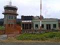 Airport of Sogamoso, located in Firavitoba
References
- 1 2 3 4 5 (Spanish) General information Firavitoba - accessed 28-04-2016
- ↑ (Spanish) Etymology Firavitoba - accessed 02-05-2016
| Wikimedia Commons has media related to Firavitoba. |
Coordinates: 5°39′N 73°00′W / 5.650°N 73.000°W